FAIRFIELD, ST SUNDAY CRAG AND RED SCREES
|
The Fairfield group continues
the line of the Helvellyn range southwards from Grisedale Tarn to the
Kirkstone Pass. It is sufficiently divided from the other fells to be
regarded as a separate section with independent lines of approach. Apart from
the deep depressions at Grisedale Tarn and the Kirkstone Pass, the other
boundaries are formed by the valleys of the Rothay to the west, and
Patterdale on the eastern side. Fairfield and it's neighbours like Helvellyn
show their finest wares to Patterdale, and the best ascents are from this
side up the little valleys of Dovedale and Deepdale where the faces of Dove
Crag and Greenhow End will be seen dominating the climb. The ridge over Hartsop
Above How too is a grand way to the main tops, but the royal road to
Fairfield must be over St Sunday Crag. The western side too has considerable
dales biting into the mass, but here it is the ridges that carry the popular
routes with the famous 'Fairfield Horseshoe' among them. Several other
circuits or horseshoes can be identified within the group giving first rate
lines of ascent to the principal ridge. St Sunday Crag and Red Screes are
reviewed here as part of the Fairfield system, and indeed are often combined
with the main summit during a walk. These two fells do have a sense of
separate identity, and have their own minor summits or satellites adding to
the choices available for exploration and ascent. St Sunday Crag has one of
the finest views of Ullswater, and the eastern side of the Helvellyn fells
are well displayed, as is Fairfield itself, which can be reached from here
along the best ridge in the group involving some easy rock handling up to the
peak of Cofa Pike. A combination of searching out the recesses and coves on
the Patterdale side with the extensive views on reaching the summits makes
this a rewarding group of hills. It is a great pity that so many people cross
Fairfield on the renowned ?horseshoe' without even making the simple short
detours to look down the crags. Fairfield is much more than an elevated
promenade.
|
|
|
|
|
----------------
|
ROUTE ONE. FAIRFIELD FROM PATTERDALE OR
GLENRIDDING VIA ARNISON CRAG, BIRKS AND ST SUNDAY CRAG.
4.5 miles 3150ft of ascent from Patterdale and 3000ft of ascent from
Glenridding direct to Birks.
|
Ascent Breakdown
|
Distance
|
Ascent
|
|
miles
|
km
|
ft
|
metres
|
|
Patterdale to Arnison Crag
|
1
|
1.6
|
925
|
282
|
|
Arnison Crag to Birks.
|
0.75
|
1.2
|
750
|
229
|
|
Birks to St Sunday Crag.
|
1.25
|
2
|
800
|
244
|
|
St Sunday Crag to Fairfield.
|
1.5
|
2.4
|
675
|
206
|
|
|
|
|
click to enlarge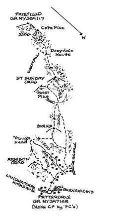
|
Starting from Patterdale
take the path to Grisedale which runs behind the Patterdale Hotel. (Can also
be accessed from the public conveniences). At a gate in the wall coming down
the fell turn up the path by the wall and climb steadily to a point where it
begins a slight descent. Here a short climb on the left on a thin path brings
the rocky top of Arnison Crag underfoot. There may be a cairn or not as I
have tried over the years to restore them as some worthy person equally
wishes to destroy them. Return to the path at the wall after admiring the
view, and follow it left crossing a hollow before traversing a low ridge. When
the shallow pass of Trough Head is crossed bear right up the bank to the old
wall which almost takes you onto the ridge of Birks. The path over Birks is
met a few yards away, and an easy section can be savoured prior to tackling
the climb to St Sunday Crag. This well worn path is the route from Grisedale
over Thornhow End. At the top of this section by some fine rocks there is one
of the finest views of Ullswater. A simple walk is all that remains to the
summit beyond which a well defined ridge goes down to Deepdale Hause with the
peak of Cofa Pike ahead changing shape as progress is made. The rocks below
Cofa Pike are an enjoyable scramble and the tiny top an airy place. From here
the path up the eroded slope in front can be climbed, or more pleasurably keep
ahead across the face to easier ground before curving left onto the summit of
Fairfield. The lane into Grisedale is the first objective from Glenridding.
Where the path from Patterdale comes in at a gate take it, but immediately
and bravely tackle the steep slope ahead. The path does not visit Birks, but
the summit is soon gained after the gradient eases if desired. Now the
journey corresponds with the Patterdale start.
|
|
----------------
|
ROUTE TWO. FAIRFIELD FROM
HARTSOP VIA HARTSOP ABOVE HOW AND HART CRAG.
3.5 miles 2600ft of ascent.
|
Ascent Breakdown
|
Distance
|
Ascent
|
|
miles
|
km
|
ft
|
metres
|
|
Hartsop (Cow Bridge) to Hartsop Above How
|
1.5
|
2.4
|
1350
|
412
|
|
Hartsop Above How to Hart Crag
|
1
|
1.6
|
925
|
282
|
|
Hart Crag to Fairfield
|
1
|
1.6
|
325
|
99
|
|
|
|
|
click to enlarge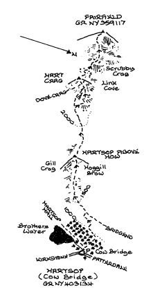
|
Go over the bridge
from the car park at Cow Bridge and through the gate on the left. Immediately
turn up a steep path through the trees which passes through deer fences
before thankfully swinging left and easing in severity. Good views of
Brothers Water are compensation for further efforts to gain the ridge by some
cairns. The path here runs left parallel to the wall and climbing before
coming to a stile over which the main ridge path from Bridgend (a possible
alternative start) will be joined. This track has become well worn over the
years, and much naked peat is encountered during the ascent not only to
Hartsop Above How but across the depression beyond. It will seem further
perhaps to Hartsop Above How than expected but keep going, and don't miss the
summit perched high above Dovedale. After negotiating the wet depression
either follow the path left of the shoulder of Hart Crag, or take the better
line and use the path climbing the rocks on the shoulder to the upper slopes.
The summit cairn lies just beyond the path crossing the summit from Dove Crag
to Fairfield. A short stony descent leads down to Link Hause with Scrubby
Crag prominent followed by a simple climb over rocks to the gentle summit
ridge. Make sure a few peeps are made down the northern face on the way for
this is Fairfield's finest scenery. A good way back to Brothers Water is over
Hart Crag and Dove Crag; there branching off the main ridge to drop down to
Little Hart Crag, and finally descending over High Hartsop Dodd
|
|
----------------
|
ROUTE THREE.
FAIRFIELD FROM AMBLESIDE VIA LOW PIKE, HIGH PIKE, DOVE CRAG AND HART CRAG.
5.5 miles 3250ft of ascent.
|
Ascent Breakdown
|
Distance
|
Ascent
|
|
miles
|
km
|
ft
|
metres
|
|
Ambleside to Low Pike
|
2.25
|
3.6
|
1500
|
457
|
|
Low Pike to High Pike.
|
0.5
|
0.8
|
600
|
183
|
|
High Pike to Dove Crag
|
1
|
1.6
|
475
|
145
|
|
Dove Crag to Hart Crag
|
0.75
|
1.2
|
350
|
107
|
|
Hart Crag to Fairfield.
|
1
|
1.6
|
325
|
99
|
|
|
|
|
click to enlarge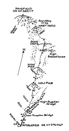
|
At the foot of the
Kirkstone Road take the first lane to the left (Low Nook Lane) and follow it
all the way to Low Sweden Bridge. A wide track now proceeds up the ridge
gradually becoming the normal walker's footpath as height is gained. Rougher
parts alternate with wetter ground as far as High Pike. The summit of Low
Pike lies off the main path and is gained by a short climb by the wall. There
are paths either side of the ridge wall higher up; that on the western side
being the best generally though the cairn on High Pike lies to the east when
the steep climbing levels out. Dove Crag is now a mile away up a widening
ridge, and the top is marked by a cairn on a little rock base again east of
the wall. In the depression below Hart Crag the wall gives up and the path
makes it's way up a stony slope to the summit. After a short rough descent
there is some simple rock scrambling to gain the almost level top of
Fairfield. Don't forget to look down the northern face! Naturally the return
to Ambleside will be to complete the ?horseshoe? down the ridge to Rydal that
features in Route Four.
|
|
----------------
|
ROUTE FOUR. FAIRFIELD
FROM RYDAL VIA NAB SCAR, HERON PIKE, AND GREAT RIGG.
4.25 miles 2950ft of ascent
|
Ascent Breakdown
|
Distance
|
Ascent
|
|
miles
|
km
|
ft
|
metres
|
|
Rydal to Nab Scar.
|
1
|
1.6
|
1275
|
389
|
|
Nab Scar to Heron Pike.
|
0.75
|
1.2
|
550
|
168
|
|
Heron Pike to Great Rigg
|
1.5
|
2.4
|
650
|
198
|
|
Great Rigg To Fairfield.
|
1
|
1.6
|
475
|
145
|
|
|
|
|
click to enlarge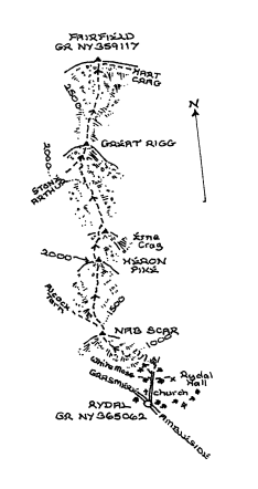
|
Go up the lane by
the church and Rydal Mount. At the head of the lane the path to Nab Scar
bears off to the left, and with the improved surface and gradients since it's
realignment the ascent is far less arduous than it used to be. Fine views of
Rydal Water are seen higher up, and then just beyond a stile the big cairn on
Nab Scar is attained; though the summit is no higher than the surrounding
area. A fine new cairn has recently been built where the path from Alcock
Tarn reaches the ridge. Some easy ground ahead is succeeded by a steady climb
to Heron Pike where a splash of quartz in the rocks will be noticed. The twin
top above Erne Crag can be visited next across a slight depression, and then
the ridge levels until the base of Great Rigg is reached. Some rocks higher
up are a welcome sight, but from Great Rigg to Fairfield there is little to
excite apart from the thought of nearing the target. On the summit make sure
the views down the northern face are seen before presumably heading off
towards Hart Crag to complete the ?horseshoe?.
|
|
----------------
|
ROUTE FIVE. FAIRFIELD
FROM GRASMERE VIA STONE ARTHUR AND GREAT RIGG. 3.5 miles
2800ft of ascent.
|
Ascent Breakdown
|
Distance
|
Ascent
|
|
miles
|
km
|
ft
|
metres
|
|
Grasmere to Stone Arthur
|
1.5
|
2.4
|
1450
|
442
|
|
Stone Arthur to Great Rigg
|
1
|
1.6
|
875
|
267
|
|
Great Rigg to Fairfield.
|
1
|
1.6
|
475
|
145
|
|
|
|
|
click to enlarge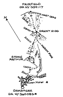
|
Walk up the lane by
the Swan Hotel and turn into a narrower one with Greenhead Gill flowing down
on the right. At the gate where the path to Alcock Tarn crosses the stream
turn left and ascend steeply by the wall. The path levels out and contours
the hillside by a ruined wall before curving up the fell to Stone Arthur.
There are two choices here with the one on the right the better underfoot.
The summit despite hardly topping the ridge has some quality because of it's
fine rocks. The climb continues up pleasant rock strewn rises before a grassy
expanse goes up to join the path from Rydal on Great Rigg. Some rocks below
the top offer a bit of variety which the final mile to Fairfield does not. If
the shelter is full and the weather is good sit down on the summit edge, and
savour the scenery of Cofa Pike and Greenhow End. The sandwiches will taste a
lot better here! Other than the same return there are several options. A
direct decent to Grisedale Hause is not very pleasant, and a longer way round
over Cofa Pike to Deepdale Hause is recommended. Here a path on the left
swings back and down to Grisedale Tarn with a short ascent then to the hause.
The path down Tongue Gill has been much improved and is a good finish to the
descent. Best of all if time and energy permits is to traverse the ridge over
Great Rigg and Heron Pike to the level area below Lord Crag. A path here
adjacent to a fine new cairn branches off on the right for Alcock Tarn and so
down to Grasmere.
|
|
----------------
|
ROUTE SIX. FAIRFIELD FROM GRASMERE VIA SEAT SANDAL.
4.25 miles 3150ft of ascent. To Seat Sandal it is 3 miles 2200ft of
ascent
|
|
|
|
click to enlarge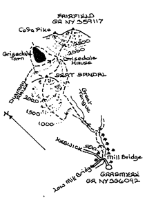
|
The ascent
starts north of the Travellers Rest Inn at the bend in the road. At the
confluence of the streams below Great Tongue bear left by Little Tongue Gill.
A narrow track follows the intake wall across to the south ridge of Seat
Sandal where a long climb though in pleasant surroundings begins. There is a
good path up the fell which is not the case descending to Grisedale Hause,
and it is far better to go down the north slope by the wall, and then
traverse above the tarn to the hause. The sterile slopes of Fairfield rise
all too clearly ahead, but ascent is better than coming down here so boldly
set forth, and after much slipping and sliding the summit will eventually be
reached. Descents are best made over Great Rigg to Stone Arthur but care is
needed near the bottom above Greenhead Gill.
|
|
|
ROUTE SEVEN. RED SCREES FROM HARTSOP AND
KIRKSTONEFOOT VIA HIGH HARTSOP DODD, LITTLE HART CRAG AND MIDDLE DODD.
4.5 miles 2550ft of ascent.
|
Ascent Breakdown
|
Distance
|
Ascent
|
|
miles
|
km
|
ft
|
metres
|
|
Hartsop (Cow Bridge) to High Hartsop Dodd
|
1.5
|
2.4
|
1200
|
366
|
|
High Hartsop Dodd to Little Hart Crag.
|
0.75
|
1.2
|
400
|
122
|
|
Little Hart Crag to Middle Dodd.
|
1.5
|
2.4
|
500
|
152
|
|
Middle Dodd to Red Screes.
|
0.75
|
1.2
|
450
|
137
|
|
|
|
|
click to enlarge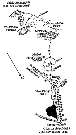
|
From Cow Bridge take
the track by Brothers Water to Hartsop Hall where the path to Kirkstone or
Scandale Passes is indicated at a stile beyond the farm. The path runs
alongside some outer buildings before following a broader track across a
field notable for some large embedded boulders to a barn at the foot of High
Hartsop Dodd. A well worn path tackles the steep ridge and the usually
recognised summit is the first rise above the cross wall marked by a small
cairn. The ridge widens as it continues to Little Hart Crag which has twin
tops and is distinguished by some crags and tiny pools. Leaving this fine
summit take the little path from the ridge below to the left and descend to
Scandale Pass. Ahead is a steady climb by the wall with a little outcropping
rock to contrast with some spongy places elsewhere. If Middle Dodd is to be
included in the ascent cross the grassy fellside left as the gradient eases
and traverse the slopes to join a wall which leads to the slight depression
near the Dodd. The summit is marked by some unusual pits which appear natural
yet seem unexpected here. Turn around now and ascend the curving ridge up to
Red Screes while enjoying the views of the Kirkstone Pass road below. Middle
Dodd may of course be visited after Red Screes in order to use the ridge beyond
as a way down. This is quite feasible but at times the gradient is steep.
Watch out for a vertical crag just below the cross wall.
|
|
----------------
|
ROUTE EIGHT. RED SCREES FROM AMBLESIDE VIA SNARKER
PIKE.
3.25 miles 2350ft of ascent.
|
|
|
|
click to enlarge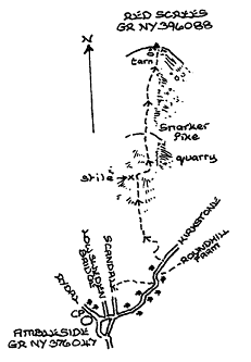
|
The
path begins almost a mile up the Kirkstone road on the left just above the
bridleway to Roundhill Farm on the other side of the road. It is marked by a
twin gate, and rises as a rather untidy lane mostly between walls until at a
stepstile more open country is reached. Avoiding the wet ground as best as
you can follow the path as it curves up to the right to gain the ridge. The
top of Snarker Pike is at the crest of the next steeper rise on the other
side of the wall. Do not explore further here as the Kirkstone slate quarry
is adjacent as the warning signs hereabouts indicate. Return to the path and
resume the ascent safely if admittedly rather lacking in interest apart from
the view. The summit is reached beyond a more level section behind the small
rounded Red Screes Tarn. Scandale Pass is the obvious route back to
Ambleside. Head in a westerly direction down a path that has become
noticeable only in recent years to a wall descending to the pass; where turn
left into the valley.
|
|
Copyright (C) 2007 B S Baker
�����������������������������������������������������������������������������������������������������������������������������������������������������������������������������������������������������������������������������������������������������������������������������������������������������������������������������������������������������������������������������������������������������������������������������������������������������������������������������������������������������������������������������������������������������������������������������������������������������������������������������������������������������������������������������������������������������������������������������������������������������������������������������������������������������������������������������������������������������������������������������������������������������������������������������������������������������������������������������������������������������������������������������������������������������������������������������������������������������������������������������������������������������������������������������������������������������������������������������������������������������������������������������������������������������������������������������������������������������������������������������������������������������������������������������������������������������������������������������������������������������������������������������������������������������������������������������������������������������������������������������������������������������������������������������������������������������������������������������������������������������������������������������������������������������������������������������������������������������������������������������������������������������������������������������������������������������������������������������������������������������������������������������������������������������������������������������������������������������������������������������������������������������������������������������������������������������������������������������������������������������������������������������������������������������������������������������������������������������������������������������������������������������������������������������������������������������������������������������������������������������������������������������������������������������������������������������������������������������������������������������������������������������������������������������������������������������������������������������������������������������������������������������������������������������������������������������������������������������������������������������������������������������������������������������������������������������������������������������������������������������������������������������������������������������������������������������������������������������������������������������������������������������������������������������������������������������������������������������������������������������������������������������������������������������������������������������������������������������������������������������������������������������������������������������������������������������������������������������������������������������������������������������������������������������������������������������������������������������������������������������������������������������������������������������������������������������������������������������������������������������������������������������������������������������������������������������������������������������������������������������������������������������������������������������������������������������������������������������������������������������������������������������������������������������������������������������������������������������������������������������������������������������������������������������������������������������������������������������������������������������������������������������������������������������������������������������������������������������������������������������������������������������������������������������������������������������������������������������������������������������������������������������������������������������������������������������������������������������������������������������������������������������������������������������������������������������������������������������������������������������������������������������������������������������������������������������������������������������������������������������������������������������������������������������������������������������������������������������������������������������������������������������������������������������������������������������������������������������������������������������������������������������������������������������������������������������������������������������������������������������������������������������������������������������������������������������������������������������������������������������������������������������������������������������������������������������������������������������������������������������������������������������������������������������������������������������������������������������������������������������������������������������������������������������������������������������������������������������������������������������������������������������������������������������������������������������������������������������������������������������������������������������������������������������������������������������������������������������������������������������������������������������������������������������������������������������������������������������������������������������������������������������������������������������������������������������������������������������������������������������������������������������������������������������������������������������������������������������������������������������������������������������������������������������������������������������������������������������������������������������������������������������������������������������������������������������������������������������������������������������������������������������������������������������������������������������������������������������������������������������������������������������������������������������������������������������������������������������������������������������������������������������������������������������������������������������������������������������������������������������������������������������������������������������������������������������������������������������������������������������������������������������������������������������������������������������������������������������������������������������������������������������������������������������������������������������������������������������������������������������������������������������������������������������������������������������������������������������������������������������������������������������������������������������������������������������������������������������������������������������������������������������������������������������������������������������������������������������������������������������������������������������������������������������������������������������������������������������������������������������������������������������������������������������������������������������������������������������������������������������������������������������������������������������������������������������������������������������������������������������������������������������������������������������������������������������������������������������������������������������������������������������������������������������������������������������������������������������������������������������������������������������������������������������������������������������������������������������������������������������������������������������������������������������������������������������������������������������������������������������������������������������������������������������������������������������������������������������������������������������������������������������������������������������������������������������������������������������������������������������������������������������������������������������������������������������������������������������������������������������������������������������������������������������������������������������������������������������������������������������������������������������������������������������������������������������������������������������������������������������������������������������������������������������������������������������������������������������������������������������������������������������������������������������������������������������������������������������������������������������������������������������������������������������������������������������������������������������������������������������������������������������������������������������������������������������������������������������������������������������������������������������������������������������������������������������������������������������������������������������������������������������������������������������������������������������������������������������������������������������������������������������������������������������������������������������������������������������������������������������������������������������������������������������������������������������������������������������������������������������������������������������������������������������������������������������������������������������������������������������������������������������������������������������������������������������������������������������������������������������������������������������������������������������������������������������������������������������������������������������������������������������������������������������������������������������������������������������������������������������������������������������������������������������������������������������������������������������������������������������������������������������������������������������������������������������������������������������������������������������������������������������������������������������������������������������������������������������������������������������������������������������������������������������������������������������������������������������������������������������������������������������������������������������������������������������������������������������������������������������������������������������������������������������������������������������������������������������������������������������������������������������������������������������������������������������������������������������������������������������������������������������������������������������������������������������������������������������������������������������������������������������������������������������������������������������������������������������������������������������������������������������������������������������������������������������������������������������������������������������������������������������������������������������������������������������������������������������������������������������������������������������������������������������������������������������������������������������������������������������������������������������������������������������������������������������������������������������������������������������������������������������������������������������������������������������������������������������������������������������������������������������������������������������������������������������������������������������������������������������������������������������������������������������������������������������������������������������������������������������������������������������������������������������������������������������������������������������������������������������������������������������������������������������������������������������������������������������������������������������������������������������������������������������������������������������������������������������������������������������������������������������������������������������������������������������������������������������������������������������������������������������������������������������������������������������������������������������������������������������������������������������������������������������������������������������������������������������������������������������������������������������������������������������������������������������������������������������������������������������������������������������������������������������������������������������������������������������������������������������������������������������������������������������������������������������������������������������������������������������������������������������������������������������������������������������������������������������������������������������������������������������������������������������������������������������������������������������������������������������������������������������������������������������������������������������������������������������������������������������������������������������������������������������������������������������������������������������������������������������������������������������������������������������������������������������������������������������������������������������������������������������������������������������������������������������������������������������������������������������������������������������������������������������������������������������������������������������������������������������������������������������������������������������������������������������������������������������������������������������������������������������������������������������������������������������������������������������������������������������������������������������������������������������������������������������������������������������������������������������������������������������������������������������������������������������������������������������������������������������������������������������������������������������������������������������������������������������������������������������������������������������������������������������������������������������������������������������������������������������������������������������������������������������������������������������������������������������������������������������������������������������������������������������������������������������������������������������������������������������������������������������������������������������������������������������������������������������������������������������������������������������������������������������������������������������������������������������������������������������������������������������������������������������������������������������������������������������������������������������������������������������������������������������������������������������������������������������������������������������������������������������������������������������������������������������������������������������������������������������������������������������������������������������������������������������������������������������������������������������������������������������������������������������������������������������������������������������������������������������������������������������������������������������������������������������������������������������������������������������������������������������������������������������������������������������������������������������������������������������������������������������������������������������������������������������������������������������������������������������������������������������������������������������������������������������������������������������������������������������������������������������������������������������������������������������������������������������������������������������������������������������������������������������������������������������������������������������������������������������������������������������������������������������������������������������������������������������������������������������������������������������������������������������������������������������������������������������������������������������������������������������������������������������������������������������������������������������������������������������������������������������������������������������������������������������������������������������������������������������������������������������������������������������������������������������������������������������������������������������������������������������������������������������������������������������������������������������������������������������������������������������������������������������������������������������������������������������������������������������������������������������������������������������������������������������������������������������������������������������������������������������������������������������������������������������������������������������������������������������������������������������������������������������������������������������������������������������������������������������������������������������������������������������������������������������������������������������������������������������������������������������������������������������������������������������������������������������������������������������������������������������������������������������������������������������������������������������������������������������������������������������������������������������������������������������������������������������������������������������������������������������������������������������������������������������������������������������������������������������������������������������������������������������������������������������������������������������������������������������������������������������������������������������������������������������������������������������������������������������������������������������������������������������������������������������������������������������������������������������������������������������������������������������������������������������������������������������������������������������������������������������������������������������������������������������������������������������������������������������������������������������������������������������������������������������������������������������������������������������������������������������������������������������������������������������������������������������������������������������������������������������������������������������������������������������������������������������������������������������������������������������������������������������������������������������������������������������������������������������������������������������������������������������������������������������������������������������������������������������������������������������������������������������������������������������������������������������������������������������������������������������������������������������������������������������������������������������������������������������������������������������������������������������������������������������������������������������������������������������������������������������������������������������������������������������������������������������������������������������������������������������������������������������������������������������������������������������������������������������������������������������������������������������������������������������������������������������������������������������������������������������������������������������������������������������������������������������������������������������������������������������������������������������������������������������������������������������������������������������������������������������������������������������������������������������������������������������������������������������������������������������������������������������������������������������������������������������������������������������������������������������������������������������������������������������������������������������������������������������������������������������������������������������������������������������������������������������������������������������������������������������������������������������������������������������������������������������������������������������������������������������������������������������������������������������������������������������������������������������������������������������������������������������������������������������������������������������������������������������������������������������������������������������������������������������������������������������������������������������������������������������������������������������������������������������������������������������������������������������������������������������������������������������������������������������������������������������������������������������������������������������������������������������������������������������������������������������������������������������������������������������������������������������������������������������������������������������������������������������������������������������������������������������������������������������������������������������������������������������������������������������������������������������������������������������������������������������������������������������������������������������������������������������������������������������������������������������������������������������������������������������������������������������������������������������������������������������������������������������������������������������������������������������������������������������������������������������������������������������������������������������������������������������������������������������������������������������������������������������������������������������������������������������������������������������������������������������������������������������������������������������������������������������������������������������������������������������������������������������������������������������������������������������������������������������������������������������������������������������������������������������������������������������������������������������������������������������������������������������������������������������������������������������������������������������������������������������������������������������������������������������������������������������������������������������������������������������������������������������������������������������������������������������������������������������������������������������������������������������������������������������������������������������������������������������������������������������������������������������������������������������������������������������������������������������������������������������������������������������������������������������������������������������������������������������������������������������������������������������������������������������������������������������������������������������������������������������������������������������������������������������������������������������������������������������������������������������������������������������������������������������������������������������������������������������������������������������������������������������������������������������������������������������������������������������������������������������������������������������������������������������������������������������������������������������������������������������������������������������������������������������������������������������������������������������������������������������������������������������������������������������������������������������������������������������������������������������������������������������������������������������������������������������������������������������������������������������������������������������������������������������������������������������������������������������������������������������������������������������������������������������������������������������������������������������������������������������������������������������������������������������������������������������������������������������������������������������������������������������������������������������������������������������������������������������������������������������������������������������������������������������������������������������������������������������������������������������������������������������������������������������������������������������������������������������������������������������������������������������������������������������������������������������������������������������������������������������������������������������������������������������������������������������������������������������������������������������������������������������������������������������������������������������������������������������������������������������������������������������������������������������������������������������������������������������������������������������������������������������������������������������������������������������������������������������������������������������������������������������������������������������������������������������������������������������������������������������������������������������������������������������������������������������������������������������������������������������������������������������������������������������������������������������������������������������������������������������������������������������������������������������������������������������������������������������������������������������������������������������������������������������������������������������������������������������������������������������������������������������������������������������������������������������������������������������������������������������������������������������������������������������������������������������������������������������������������������������������������������������������������������������������������������������������������������������������������������������������������������������������������������������������������������������������������������������������������������������������������������������������������������������������������������������������������������������������������������������������������������������������������������������������������������������������������������������������������������������������������������������������������������������������������������������������������������������������������������������������������������������������������������������������������������������������������������������������������������������������������������������������������������������������������������������������������������������������������������������������������������������������������������������������������������������������������������������������������������������������������������������������������������������������������������������������������������������������������������������������������������������������������������������������������������������������������������������������������������������������������������������������������������������������������������������������������������������������������������������������������������������������������������������������������������������������������������������������������������������������������������������������������������������������������������������������������������������������������������������������������������������������������������������������������������������������������������������������������������������������������������������������������������������������������������������������������������������������������������������������������������������������������������������������������������������������������������������������������������������������������������������������������������������������������������������������������������������������������������������������������������������������������������������������������������������������������������������������������������������������������������������������������������������������������������������������������������������������������������������������������������������������������������������������������������������������������������������������������������������������������������������������������������������������������������������������������������������������������������������������������������������������������������������������������������������������������������������������������������������������������������������������������������������������������������������������������������������������������������������������������������������������������������������������������������������������������������������������������������������������������������������������������������������������������������������������������������������������������������������������������������������������������������������������������������������������������������������������������������������������������������������������������������������������������������������������������������������������������������������������������������������������������������������������������������������������������������������������������������������������������������������������������������������������������������������������������������������������������������������������������������������������������������������������������������������������������������������������������������������������������������������������������������������������������������������������������������������������������������������������������������������������������������������������������������������������������������������������������������������������������������������������������������������������������������������������������������������������������������������������������������������������������������������������������������������������������������������������������������������������������������������������������������������������������������������������������������������������������������������������������������������������������������������������������������������������������������������������������������������������������������������������������������������������������������������������������������������������������������������������������������������������������������������������������������������������������������������������������������������������������������������������������������������������������������������������������������������������������������������������������������������������������������������������������������������������������������������������������������������������������������������������������������������������������������������������������������������������������������������������������������������������������������������������������������������������������������������������������������������������������������������������������������������������������������������������������������������������������������������������������������������������������������������������������������������������������������������������������������������������������������������������������������������������������������������������������������������������������������������������������������������������������������������������������������������������������������������������������������������������������������������������������������������������������������������������������������������������������������������������������������������������������������������������������������������������������������������������������������������������������������������������������������������������������������������������������������������������������������������������������������������������������������������������������������������������������������������������������������������������������������������������������������������������������������������������������������������������������������������������������������������������������������������������������������������������������������������������������������������������������������������������������������������������������������������������������������������������������������������������������������������������������������������������������������������������������������������������������������������������������������������������������������������������������������������������������������������������������������������������������������������������������������������������������������������������������������������������������������������������������������������������������������������������������������������������������������������������������������������������������������������������������������������������������������������������������������������������������������������������������������������������������������������������������������������������������������������������������������������������������������������������������������������������������������������������������������������������������������������������������������������������������������������������������������������������������������������������������������������������������������������������������������������������������������������������������������������������������������������������������������������������������������������������������������������������������������������������������������������������������������������������������������������������������������������������������������������������������������������������������������������������������������������������������������������������������������������������������������������������������������������������������������������������������������������������������������������������������������������������������������������������������������������������������������������������������������������������������������������������������������������������������������������������������������������������������������������������������������������������������������������������������������������������������������������������������������������������������������������������������������������������������������������������������������������������������������������������������������������������������������������������������������������������������������������������������������������������������������������������������������������������������������������������������������������������������������������������������������������������������������������������������������������������������������������������������������������������������������������������������������������������������������������������������������������������������������������������������������������������������������������������������������������������������������������������������������������������������������������������������������������������������������������������������������������������������������������������������������������������������������������������������������������������������������������������������������������������������������������������������������������������������������������������������������������������������������������������������������������������������������������������������������������������������������������������������������������������������������������������������������������������������������������������������������������������������������������������������������������������������������������������������������������������������������������������������������������������������������������������������������������������������������������������������������������������������������������������������������������������������������������������������������������������������������������������������������������������������������������������������������������������������������������������������������������������������������������������������������������������������������������������������������������������������������������������������������������������������������������������������������������������������������������������������������������������������������������������������������������������������������������������������������������������������������������������������������������������������������������������������������������������������������������������������������������������������������������������������������������������������������������������������������������������������������������������������������������������������������������������������������������������������������������������������������������������������������������������������������������������������������������������������������������������������������������������������������������������������������������������������������������������������������������������������������������������������������������������������������������������������������������������������������������������������������������������������������������������������������������������������������������������������������������������������������������������������������������������������������������������������������������������������������������������������������������������������������������������������������������������������������������������������������������������������������������������������������������������������������������������������������������������������������������������������������������������������������������������������������������������������������������������������������������������������������������������������������������������������������������������������������������������������������������������������������������������������������������������������������������������������������������������������������������������������������������������������������������������������������������������������������������������������������������������������������������������������������������������������������������������������������������������������������������������������������������������������������������������������������������������������������������������������������������������������������������������������������������������������������������������������������������������������������������������������������������������������������������������������������������������������������������������������������������������������������������������������������������������������������������������������������������������������������������������������������������������������������������������������������������������������������������������������������������������������������������������������������������������������������������������������������������������������������������������������������������������������������������������������������������������������������������������������������������������������������������������������������������������������������������������������������������������������������������������������������������������������������������������������������������������������������������������������������������������������������������������������������������������������������������������������������������������������������������������������������������������������������������������������������������������������������������������������������������������������������������������������������������������������������������������������������������������������������������������������������������������������������������������������������������������������������������������������������������������������������������������������������������������������������������������������������������������������������������������������������������������������������������������������������������������������������������������������������������������������������������������������������������������������������������������������������������������������������������������������������������������������������������������������������������������������������������������������������������������������������������������������������������������������������������������������������������������������������������������������������������������������������������������������������������������������������������������������������������������������������������������������������������������������������������������������������������������������������������������������������������������������������������������������������������������������������������������������������������������������������������������������������������������������������������������������������������������������������������������������������������������������������������������������������������������������������������������������������������������������������������������������������������������������������������������������������������������������������������������������������������������������������������������������������������������������������������������������������������������������������������������������������������������������������������������������������������������������������������������������������������������������������������������������������������������������������������������������������������������������������������������������������������������������������������������������������������������������������������������������������������������������������������������������������������������������������������������������������������������������������������������������������������������������������������������������������������������������������������������������������������������������������������������������������������������������������������������������������������������������������������������������������������������������������������������������������������������������������������������������������������������������������������������������������������������������������������������������������������������������������������������������������������������������������������������������������������������������������������������������������������������������������������������������������������������������������������������������������������������������������������������������������������������������������������������������������������������������������������������������������������������������������������������������������������������������������������������������������������������������������������������������������������������������������������������������������������������������������������������������������������������������������������������������������������������������������������������������������������������������������������������������������������������������������������������������������������������������������������������������������������������������������������������������������������������������������������������������������������������������������������������������������������������������������������������������������������������������������������������������������������������������������������������������������������������������������������������������������������������������������������������������������������������������������������������������������������������������������������������������������������������������������������������������������������������������������������������������������������������������������������������������������������������������������������������������������������������������������������������������������������������������������������������������������������������������������������������������������������������������������������������������������������������������������������������������������������������������������������������������������������������������������������������������������������������������������������������������������������������������������������������������������������������������������������������������������������������������������������������������������������������������������������������������������������������������������������������������������������������������������������������������������������������������������������������������������������������������������������������������������������������������������������������������������������������������������������������������������������������������������������������������������������������������������������������������������������������������������������������������������������������������������������������������������������������������������������������������������������������������������������������������������������������������������������������������������������������������������������������������������������������������������������������������������������������������������������������������������������������������������������������������������������������������������������������������������������������������������������������������������������������������������������������������������������������������������������������������������������������������������������������������������������������������������������������������������������������������������������������������������������������������������������������������������������������������������������������������������������������������������������������������������������������������������������������������������������������������������������������������������������������������������������������������������������������������������������������������������������������������������������������������������������������������������������������������������������������������������������������������������������������������������������������������������������������������������������������������������������������������������������������������������������������������������������������������������������������������������������������������������������������������������������������������������������������������������������������������������������������������������������������������������������������������������������������������������������������������������������������������������������������������������������������������������������������������������������������������������������������������������������������������������������������������������������������������������������������������������������������������������������������������������������������������������������������������������������������������������������������������������������������������������������������������������������������������������������������������������������������������������������������������������������������������������������������������������������������������������������������������������������������������������������������������������������������������������������������������������������������������������������������������������������������������������������������������������������������������������������������������������������������������������������������������������������������������������������������������������������������������������������������������������������������������������������������������������������������������������������������������������������������������������������������������������������������������������������������������������������������������������������������������������������������������������������������������������������������������������������������������������������������������������������������������������������������������������������������������������������������������������������������������������������������������������������������������������������������������������������������������������������������������������������������������������������������������������������������������������������������������������������������������������������������������������������������������������������������������������������������������������������������������������������������������������������������������������������������������������������������������������������������������������������������������������������������������������������������������������������������������������������������������������������������������������������������������������������������������������������������������������������������������������������������������������������������������������������������������������������������������������������������������������������������������������������������������������������������������������������������������������������������������������������������������������������������������������������������������������������������������������������������������������������������������������������������������������������������������������������������������������������������������������������������������������������������������������������������������������������������������������������������������������������������������������������������������������������������������������������������������������������������������������������������������������������������������������������������������������������������������������������������������������������������������������������������������������������������������������������������������������������������������������������������������������������������������������������������������������������������������������������������������������������������������������������������������������������������������������������������������������������������������������������������������������������������������������������������������������������������������������������������