HIGH SREET AND ILL BELL
|
High Street is the
culminating point of the Roman road that follows the main watershed east of
the Kirkstone Pass and Ullswater from Troutbeck to Moor Divock. It's
superiority in height over the rest of the fells in the group will often be
all that many of it's visitors will recall of it later, for High Street only
displays it's finest features to Mardale Head. On some ascents the fell is so
well buttressed by neighbouring tops that it remains hidden until the final
stages of the climb. All these fells are best appreciated from their eastern
side; in the case of the Ill Bell ridge as seen from Kentmere, while High
Street must be viewed from Haweswater, and Mardale Head should be the
starting point for the climb. Here are rocky coves and recesses and a superb
crag bound narrow ridge that rises from the foot of Riggindale at The Rigg
pointing the way directly to the summit of the parent fell. From this ridge
Blea Water the deepest of Lakelands tarns is displayed in it's comb, and is
considered by some to be the finest of all the mountain tarns in the
district. This route of ascent to High Street over Rough Crag and up the
narrow Long Stile must be one of the best ascents there is, and coupled with
a circuit round to Harter Fell makes a truly memorable walk. A special
feature of these fells are the long easy ridges all carrying good paths which
are a pleasure to tread. Scenery and views change quickly here, though the
Ill Bell ridge has some rougher ground as does the ridge between Caudale Moor
and Thornthwaite Crag. At one time the High Street was a haven of
tranquility, but as elsewhere has become alive with walkers enjoying the
attractions of these hills. While Kentmere and Mardale form the eastern
boundaries, and Kirkstone and the Patterdale Valley the western, the hills
decline southwards to the Garburn Pass, and eventually to the foothills above
the road from Kendal to Windermere. Beyond the Straits of Riggindale north of
High Street high ground continues over High Raise and Loadpot Hill to the
fertile Lowther Valley. Please plan your walks so that the best of these
hills can be appreciated, and if High Street has to be ascended from the
south or west at least make the short detour to look down on Blea Water and
the head of Mardale, for here is the reward for the climb.
|
|
|
|
|
----------------
|
ROUTE ONE. HIGH STREET FROM MARDALE HEAD VIA ROUGH
CRAG.
3 miles 2000ft of ascent. 2 miles 1250ft of ascent to Rough Crag.
|
|
|
|
click to enlarge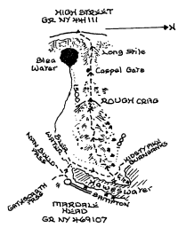
|
Follow the path
round the head of Haweswater to the top of the rise at The Rigg. At this
point turn left up the rising ridge. Further advice is really unnecessary as
the path and ridge are locked together all the way over Rough Crag, and up
the steeper section of Long Stile to the summit. There are fine views across
to Harter Fell and of Blea Water while the face of High Street commands
attention as Rough Crag is approached and beyond. There is a fair descent to
the depression at Caspel Gate (marked by a small tarn) between Rough Crag and
Long Stile. Return to Mardale Head over Kidsty Pike or go round to Nan Bield
Pass via Mardale Ill Bell, and descend to Small Water.
|
|
----------------
|
ROUTE TWO. HIGH STREET FROM MARDALE HEAD OR
KENTMERE VIA MARDALE ILL BELL.
3 miles 2050ft of ascent from Mardale. 5.5 miles 2350ft of ascent from
Kentmere. To Mardale Ill Bell it is 2 miles and 1700ft of ascent from Mardale
Head, and 4.5 miles and 2000ft of ascent from Kentmere
|
|
|
|
click to enlarge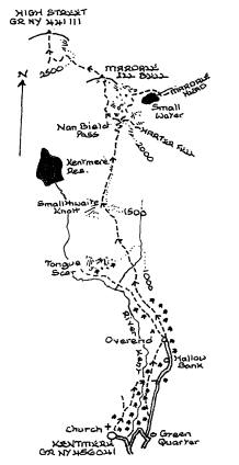
|
I have no doubt
that from Kentmere the ridge over Kentmere Pike to Harter Fell as part of the
Kentmere Horseshoe will appeal to many stronger walkers. These fells are
considered in the next section; so a reference to the notes there can be
linked to this ascent description. A track east of the church at Kentmere
leads by the farm of Rook Howe, and just beyond a footbridge allows a
crossing of the River Kent. The path ascends to Low Lane; where turn left for
Overend the last habitation on this route. At Overend make sure the path to
Nan Bield is selected (The one on the right) as the two run together for a
time. Our track climbs up to the east of Tongue Scar rounding Smallthwaite
Knott, and rises to Nan Bield Pass. In years long passed the zig zags just
below the pass were a joy to see and follow. Sadly this is no longer so, but
the alignment remains clear to anyone interested. Turn up to the left at the
shelter and let the walkers highway take you up to Mardale Ill Bell whose
cairn lies just off the path. Rejoin the path and it will safely convey you
to High Street. Try to make a detour to look down on Blea Water. I have always
considered it a cardinal sin to visit High Street and not do so. From Mardale
Head go directly ahead up the valley of Small Water Beck. A steady climb
under the cliffs of Harter Fell lies in front, and then Small Water suddenly
appears; one of lakelands finest tarns. The path passes some interesting
shelters as it rounds the tarn prior to climbing steeply and stonily to Nan
Bield Pass where turn right for Mardale Ill Bell. Strong walkers can return
to Kentmere over the Ill Bell ridge, whereas for Mardale the classic way
would be down the ridge of Long Stile and Rough Crag. A bit longer and the
summits of Rampsgill Head and Kidsty Pike can be visited descending over
Kidsty Howes to Riggindale.
|
|
----------------
|
ROUTE THREE. HIGH
STREET FROM KENTMERE OR TROUTBECK VIA YOKE, ILL BELL, FROSWICK AND
THORNTHWAITE CRAG.
5.75 miles 3125ft of ascent from Kentmere. From Troutbeck to Yoke add 1 mile and 125ft of ascent.
|
Ascent Breakdown
|
Distance
|
Ascent
|
|
miles
|
km
|
ft
|
metres
|
|
Kentmere to Yoke
|
2.75
|
4.4
|
1775
|
541
|
|
Yoke to Ill Bell.
|
0.5
|
0.8
|
300
|
91
|
|
Ill Bell to Froswick.
|
0.5
|
0.8
|
325
|
99
|
|
Froswick to Thornthwaite Crag.
|
1
|
1.6
|
475
|
145
|
|
Thornthwaite Crag to High Street.
|
1
|
1.6
|
250
|
76
|
|
|
|
|
click to enlarge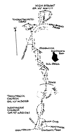
|
Leaving Kentmere Church
continue up the lane to the cluster of buildings at the foot of the Garburn
Road. Turn left here and climb the track which sadly in recent times has been
badly damaged by off road vehicles. In the prominent hollow just below the
summit of the pass a path will be noticed on the right that makes it's way to
the ridge below Buck Crag. This cuts a corner, but from Troutbeck the Garburn
Road must be followed to the top; where a cairn just before the wall is
reached indicates the start of the path to Yoke. Once on the ridge the paths
are such that losing them would be a sin. Much of the route has now been
improved over the wetter peaty areas. A stile in the final wall is followed
by a steeper section to the summit of Yoke. The traverse of Ill Bell and
Froswick is the highlight of the walk with fine views down into Kentmere.
This is succeeded by a long haul up to Thornthwaite Crag and it's beacon;
though some walkers may head directly to High Street. The path connecting the
two fells is evidence of it's usage as it curves round the head of
Hayeswater. High Streets summit is on the line of the wall to the right, and
marked by an Ordnance Survey column. Descents to Kentmere are best over
Mardale Ill Bell to Nan Bield Pass; where those with energy left will go on
to climb Harter Fell and Kentmere Pike. For Troutbeck return to the ridge
below Thornthwaite Crag, and bear to the right to locate Scot Rake and
descend to Hagg Gill.
|
|
----------------
|
ROUTE FOUR. HIGH
STREET FROM TROUTBECK VIA TROUTBECK TONGUE AND THORNTHWAITE CRAG.
5.5 miles 2625ft of ascent.
|
Ascent Breakdown
|
Distance
|
Ascent
|
|
miles
|
km
|
ft
|
metres
|
|
Troutbeck to The Tongue.
|
2
|
3.2
|
750
|
229
|
|
The Tongue to Thornthwaite Crag
|
2.5
|
4
|
1625
|
495
|
|
Thornthwaite Crag to High Street
|
1
|
1.6
|
250
|
76
|
|
|
|
|
click to enlarge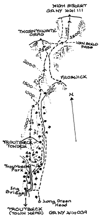
|
Take Ing Lane from Town Head
and follow it past Ing Bridge to a signpost ahead of Troutbeck Park Farm.
Ascend the pasture to a track rounding the eastern side of Troutbeck Tongue.
As the path turns and straightens above Hagg Gill leave it to go up by the
wall coming down on the left. The first bit is rather marshy, but round the
corner the path will clearly be seen ascending the fellside. It climbs to the
ridge and pleasantly leads up to the summit cairn. From the summit descend
the ridge north on a definite path crossing a fence by a new stile to the
foot of Scot Rake. Beyond the gate a stiff climb has to be undertaken before
the slopes ease as Thornthwaite Crag is approached. Once again the skill and
efforts of those who created paths such as Scot Rake can be appreciated. The
last mile to High Street is a simple traverse round the head of Hayeswater
but branch right to the wall for the summit. The Ill Bell ridge would be the
obvious route back to Troutbeck, but less arduous and a variation to the
ascent would be to descend from Thornthwaite Crag to Threshthwaite Mouth and
turn left down to Trout Beck. This keeps west of The Tongue to Troutbeck
Park, but note the ground can be very wet here.
|
|
----------------
|
ROUTE FIVE. HIGH STREET FROM KIRKSTONE PASS VIA SATTEREVEN
(St Ravens Edge),
CAUDALE MOOR AND THORNTHWAITE CRAG.
4 miles 2075ft of ascent.
|
Ascent Breakdown
|
Distance
|
Ascent
|
|
miles
|
km
|
ft
|
metres
|
|
Kirkstone Pass to Sattereven (St Ravens Edge)
|
0.5
|
0.8
|
500
|
153
|
|
Sattereven to Caudale Moor.
|
1.5
|
2.4
|
700
|
214
|
|
Caudale Moor to Thornthwaite Crag.
|
1
|
1.6
|
625
|
191
|
|
Thornthwaite Crag to High Street
|
1
|
1.6
|
250
|
76
|
|
|
|
|
click to enlarge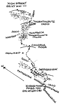
|
On the
northern side of the Kirkstone Pass Inn a stile indicates the start of this
walk. The initial climb to Sattereven (St Ravens Edge) is an early challenge
to take on. The top is strictly unnamed but I like the name Sattereven which
more properly applies to an area nearby as do other names in the district
including St Ravens Edge here. A wall is a companion up the fellside, and
will be so right up to the summit of Caudale Moor with a few changes of
direction en route. There is some loss of height as Sattereven or St Ravens
Edge is left, but a little peaty ground apart the going is easy enough. The
ascent that follows is nowhere steep but may seem rather longer than
anticipated. Cross the wall to the summit cairn from where the path begins
the descent to Threshthwaite Mouth. Newcomers may be surprised by the rocky
conditions lower down and the depth of the col. Less of a shock as it is all
too clear will be the steep stony climb on the other side to Thornthwaite
Crag. Matters can be alleviated a little by taking a loop out to the left of
the wall to the ridge from Gray Crag. After this the rest of the walk to High
Street over a shallow depression will be much appreciated. The Ordnance
Survey column is adjacent to the ridge wall. There are no easy options to return
to the pass. Even the route of ascent involves some 700ft of ascent. This
route is best as part of a linear walk using more than one car, or perhaps
returning by bus from the lane end at Hartsop after descending to Hayeswater
via The Knott.
|
|
----------------
|
ROUTE SIX. HIGH STREET FROM HARTSOP VIA HARTSOP
DODD, CAUDALE MOOR AND THORNTHWAITE CRAG.
4 miles 2925ft of ascent.
|
Ascent Breakdown
|
Distance
|
Ascent
|
|
miles
|
km
|
ft
|
metres
|
|
Hartsop to Hartsop Dodd.
|
0.75
|
1.2
|
1450
|
442
|
|
Hartsop Dodd to CaudaleMoor.
|
1.25
|
2
|
600
|
183
|
|
Caudale Moor to Thornthwaite Crag
|
1
|
1.6
|
625
|
191
|
|
Thornthwaite Crag
to High Street.
|
1
|
1.6
|
250
|
76
|
|
|
|
|
click to enlarge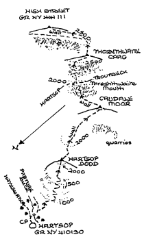
|
Make
no mistake the ascent of Hartsop Dodd is all that it appears to be! If it
must be done go over Walker Bridge below the car park and ascend the steep
lower pasture to the angle of the intake walls. An attempt has been made to
improve the path here. The ridge takes shape now, and what was once a
beautiful series of zig zags makes even this slope quite acceptable. One can
only marvel at the way these paths were constructed. The final rise to the
summit is rather eroded, but from the top to Caudale Moor the pleasant going
is some reward for earlier toil. The view back from the Dodd during the
ascent is a good excuse for several halts. From Caudale Moor the path heads
north east to the wall before dropping rather roughly to Threshthwaite Mouth.
A loop to the left to avoid the devastation ahead can be made joining the
ridge from Gray Crag. The last mile to High Street is by comparison with
earlier experiences a doddle. Return to Hartsop over The Knott and descend to
Hayeswater. If there is still time and energy left a visit to Kidsty Pikc and
Rampsgill Head could
also be considered.
|
|
----------------
|
ROUTE SEVEN. HIGH STREET FROM HARTSOP VIA GRAY
CRAG AND THORNTHWAITE CRAG.
4.25 miles 2350ft of ascent
|
Ascent Breakdown
|
Distance
|
Ascent
|
|
miles
|
km
|
ft
|
metres
|
|
Hartsop to Gray Crag.
|
2
|
3.2
|
1725
|
526
|
|
Gray Crag to Thornthwaite Crag.
|
1.25
|
2
|
375
|
114
|
|
Thornthwaite Crag to High Street
|
1
|
1.6
|
250
|
84
|
|
|
|
|
click to enlarge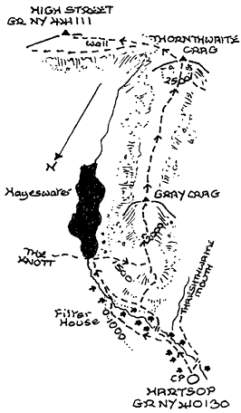
|
Go up the lane
past the sheep pens but at the junction turn down the track to cross Wath
Bridge. The track now winds around the flank of Gray Crag and climbing
steadily leads to Hayeswater. Above a gate a path may be noticed steeply
climbing the slopes to the ridge. If this seems rather too much then continue
ahead to the tarn. There is a path from the filter house up to this track
which makes a pleasant alternative. At the tarn go up the grassy slopes
tending slightly to the right to meet the ridge lower down. A good path
ascends the ridge to Gray Crag and can then be clearly followed to
Thornthwaite Crag. Make sure the views down the steep flank to Hayeswater are
seen on the way. From the beacon an easy mile round the head of Hayeswater
Gill is all that remains. The obvious way back is over The Knott, but firstly
a visit to Kidsty Pike is recommended before crossing Rampsgill Head to The
Knott. A descent to Hayeswater completes the circuit. Stronger walkers may
also add Rest Dodd and Brock Crags to the itinery.
|
|
Copyright (C) 2007 B S Baker
�����������������������������������������������������������������������������������������������������������������������������������������������������������������������������������������������������������������������������������������������������������������������������������������������������������������������������������������������������������������������������������������������������������������������������������������������������������������������������������������������������������������������������������������������������������������������������������������������������������������������������������������������������������������������������������������������������������������������������������������������������������������������������������������������������������������������������������������������������������������������������������������������������������������������������������������������������������������������������������������������������������������������������������������������������������������������������������������������������������������������������������������������������������������������������������������������������������������������������������������������������������������������������������������������������������������������������������������������������������������������������������������������������������������������������������������������������������������������������������������������������������������������������������������������������������������������������������������������������������������������������������������������������������������������������������������������������������������������������������������������������������������������������������������������������������������������������������������������������������������������������������������������������������������������������������������������������������������������������������������������������������������������������������������������������������������������������������������������������������������������������������������������������������������������������������������������������������������������������������������������������������������������������������������������������������������������������������������������������������������������������������������������������������������������������������������������������������������������������������������������������������������������������������������������������������������������������������������������������������������������������������������������������������������������������������������������������������������������������������������������������������������������������������������������������������������������������������������������������������������������������������������������������������������������������������������������������������������������������������������������������������������������������������������������������������������������������������������������������������������������������������������������������������������������������������������������������������������������������������������������������������������������������������������������������������������������������������������������������������������������������������������������������������������������������������������������������������������������������������������������������������������������������������������������������������������������������������������������������������������������������������������������������������������������������������������������������������������������������������������������������������������������������������������������������������������������������������������������������������������������������������������������������������������������������������������������������������������������������������������������������������������������������������������������������������������������������������������������������������������������������������������������������������������������������������������������������������������������������������������������������������������������������������������������������������������������������������������������������������������������������������������������������������������������������������������������������������������������������������������������������������������������������������������������������������������������������������������������������������������������������������������������������������������������������������������������������������������������������������������������������������������������������������������������������������������������������������������������������������������������������������������������������������������������������������������������������������������������������������������������������������������������������������������������������������������������������������������������������������������������������������������������������������������������������������������������������������������������������������������������������������������������������������������������������������������������������������������������������������������������������������������������������������������������������������������������������������������������������������������������������������������������������������������������������������������������������������������������������������������������������������������������������������������������������������������������������������������������������������������������������������������������������������������������������������������������������������������������������������������������������������������������������������������������������������������������������������������������������������������������������������������������������������������������������������������������������������������������������������������������������������������������������������������������������������������������������������������������������������������������������������������������������������������������������������������������������������������������������������������������������������������������������������������������������������������������������������������������������������������������������������������������������������������������������������������������������������������������������������������������������������������������������������������������������������������������������������������������������������������������������������������������������������������������������������������������������������������������������������������������������������������������������������������������������������������������������������������������������������������������������������������������������������������������������������������������������������������������������������������������������������������������������������������������������������������������������������������������������������������������������������������������������������������������������������������������������������������������������������������������������������������������������������������������������������������������������������������������������������������������������������������������������������������������������������������������������������������������������������������������������������������������������������������������������������������������������������������������������������������������������������������������������������������������������������������������������������������������������������������������������������������������������������������������������������������������������������������������������������������������������������������������������������������������������������������������������������������������������������������������������������������������������������������������������������������������������������������������������������������������������������������������������������������������������������������������������������������������������������������������������������������������������������������������������������������������������������������������������������������������������������������������������������������������������������������������������������������������������������������������������������������������������������������������������������������������������������������������������������������������������������������������������������������������������������������������������������������������������������������������������������������������������������������������������������������������������������������������������������������������������������������������������������������������������������������������������������������������������������������������������������������������������������������������������������������������������������������������������������������������������������������������������������������������������������������������������������������������������������������������������������������������������������������������������������������������������������������������������������������������������������������������������������������������������������������������������������������������������������������������������������������������������������������������������������������������������������������������������������������������������������������������������������������������������������������������������������������������������������������������������������������������������������������������������������������������������������������������������������������������������������������������������������������������������������������������������������������������������������������������������������������������������������������������������������������������������������������������������������������������������������������������������������������������������������������������������������������������������������������������������������������������������������������������������������������������������������������������������������������������������������������������������������������������������������������������������������������������������������������������������������������������������������������������������������������������������������������������������������������������������������������������������������������������������������������������������������������������������������������������������������������������������������������������������������������������������������������������������������������������������������������������������������������������������������������������������������������������������������������������������������������������������������������������������������������������������������������������������������������������������������������������������������������������������������������������������������������������������������������������������������������������������������������������������������������������������������������������������������������������������������������������������������������������������������������������������������������������������������������������������������������������������������������������������������������������������������������������������������������������������������������������������������������������������������������������������������������������������������������������������������������������������������������������������������������������������������������������������������������������������������������������������������������������������������������������������������������������������������������������������������������������������������������������������������������������������������������������������������������������������������������������������������������������������������������������������������������������������������������������������������������������������������������������������������������������������������������������������������������������������������������������������������������������������������������������������������������������������������������������������������������������������������������������������������������������������������������������������������������������������������������������������������������������������������������������������������������������������������������������������������������������������������������������������������������������������������������������������������������������������������������������������������������������������������������������������������������������������������������������������������������������������������������������������������������������������������������������������������������������������������������������������������������������������������������������������������������������������������������������������������������������������������������������������������������������������������������������������������������������������������������������������������������������������������������������������������������������������������������������������������������������������������������������������������������������������������������������������������������������������������������������������������������������������������������������������������������������������������������������������������������������������������������������������������������������������������������������������������������������������������������������������������������������������������������������������������������������������������������������������������������������������������������������������������������������������������������������������������������������������������������������������������������������������������������������������������������������������������������������������������������������������������������������������������������������������������������������������������������������������������������������������������������������������������������������������������������������������������������������������������������������������������������������������������������������������������������������������������������������������������������������������������������������������������������������������������������������������������������������������������������������������������������������������������������������������������������������������������������������������������������������������������������������������������������������������������������������������������������������������������������������������������������������������������������������������������������������������������������������������������������������������������������������������������������������������������������������������������������������������������������������������������������������������������������������������������������������������������������������������������������������������������������������������������������������������������������������������������������������������������������������������������������������������������������������������������������������������������������������������������������������������������������������������������������������������������������������������������������������������������������������������������������������������������������������������������������������������������������������������������������������������������������������������������������������������������������������������������������������������������������������������������������������������������������������������������������������������������������������������������������������������������������������������������������������������������������������������������������������������������������������������������������������������������������������������������������������������������������������������������������������������������������������������������������������������������������������������������������������������������������������������������������������������������������������������������������������������������������������������������������������������������������������������������������������������������������������������������������������������������������������������������������������������������������������������������������������������������������������������������������������������������������������������������������������������������������������������������������������������������������������������������������������������������������������������������������������������������������������������������������������������������������������������������������������������������������������������������������������������������������������������������������������������������������������������������������������������������������������������������������������������������������������������������������������������������������������������������������������������������������������������������������������������������������������������������������������������������������������������������������������������������������������������������������������������������������������������������������������������������������������������������������������������������������������������������������������������������������������������������������������������������������������������������������������������������������������������������������������������������������������������������������������������������������������������������������������������������������������������������������������������������������������������������������������������������������������������������������������������������������������������������������������������������������������������������������������������������������������������������������������������������������������������������������������������������������������������������������������������������������������������������������������������������������������������������������������������������������������������������������������������������������������������������������������������������������������������������������������������������������������������������������������������������������������������������������������������������������������������������������������������������������������������������������������������������������������������������������������������������������������������������������������������������������������������������������������������������������������������������������������������������������������������������������������������������������������������������������������������������������������������������������������������������������������������������������������������������������������������������������������������������������������������������������������������������������������������������������������������������������������������������������������������������������������������������������������������������������������������������������������������������������������������������������������������������������������������������������������������������������������������������������������������������������������������������������������������������������������������������������������������������������������������������������������������������������������������������������������������������������������������������������������������������������������������������������������������������������������������������������������������������������������������������������������������������������������������������������������������������������������������������������������������������������������������������������������������������������������������������������������������������������������������������������������������������������������������������������������������������������������������������������������������������������������������������������������������������������������������������������������������������������������������������������������������������������������������������������������������������������������������������������������������������������������������������������������������������������������������������������������������������������������������������������������������������������������������������������������������������������������������������������������������������������������������������������������������������������������������������������������������������������������������������������������������������������������������������������������������������������������������������������������������������������������������������������������������������������������������������������������������������������������������������������������������������������������������������������������������������������������������������������������������������������������������������������������������������������������������������������������������������������������������������������������������������������������������������������������������������������������������������������������������������������������������������������������������������������������������������������������������������������������������������������������������������������������������������������������������������������������������������������������������������������������������������������������������������������������������������������������������������������������������������������������������������������������������������������������������������������������������������������������������������������������������������������������������������������������������������������������������������������������������������������������������������������������������������������������������������������������������������������������������������������������������������������������������������������������������������������������������������������������������������������������������������������������������������������������������������������������������������������������������������������������������������������������������������������������������������������������������������������������������������������������������������������������������������������������������������������������������������������������������������������������������������������������������������������������������������������������������������������������������������������������������������������������������������������������������������������������������������������������������������������������������������������������������������������������������������������������������������������������������������������������������������������������������������������������������������������������������������������������������������������������������������������������������������������������������������������������������������������������������������������������������������������������������������������������������������������������������������������������������������������������������������������������������������������������������������������������������������������������������������������������������������������������������������������������������������������������������������������������������������������������������������������������������������������������������������������������������������������������������������������������������������������������������������������������������������������������������������������������������������������������������������������������������������������������������������������������������������������������������������������������������������������������������������������������������������������������������������������������������������������������������������������������������������������������������������������������������������������������������������������������������������������������������������������������������������������������������������������������������������������������������������������������������������������������������������������������������������������������������������������������������������������������������������������������������������������������������������������������������������������������������������������������������������������������������������������������������������������������������������������������������������������������������������������������������������������������������������������������������������������������������������������������������������������������������������������������������������������������������������������������������������������������������������������������������������������������������������������������������������������������������������������������������������������������������������������������������������������������������������������������������������������������������������������������������������������������������������������������������������������������������������������������������������������������������������������������������������������������������������������������������������������������������������������������������������������������������������������������������������������������������������������������������������������������������������������������������������������������������������������������������������������������������������������������������������������������������������������������������������������������������������������������������������������������������������������������������������������������������������������������������������������������������������������������������������������������������������������������������������������������������������������������������������������������������������������������������������������������������������������������������������������������������������������������������������������������������������������������������������������������������������������������������������������������������������������������������������������������������������������������������������������������������������������������������������������������������������������������������������������������������������������������������������������������������������������������������������������������������������������������������������������������������������������������������������������������������������������������������������������������������������������������������������������������������������������������������������������������������������������������������������������������������������������������������������������������������������������������������������������������������������������������������������������������������������������������������������������������������������������������������������������������������������������������������������������������������������������������������������������������������������������������������������������������������������������������������������������������������������������������������������������������������������������������������������������������������������������������������������������������������������������������������������������������������������������������������������������������������������������������������������������������������������������������������������������������������������������������������������������������������������������������������������������������������������������������������������������������������������������������������������������������������������������������������������������������������������������������������������������������������������������������������������������������������������������������������������������������������������������������������������������������������������������������������������������������������������������������������������������������������������������������������������������������������������������������������������������������������������������������������������������������������������������������������������������������������������������������������������������������������������������������������������������������������������������������������������������������������������������������������������������������������������������������������������������������������������������������������������������������������������������������������������������������������������������������������������������������������������������������������������������������������������������������������������������������������������������������������������������������������������������������������������������������������������������������������������������������������������������������������������������������������������������������������������������������������������������������������������������������������������������������������������������������������������������������������������������������������������������������������������������������������������������������������������������������������������������������������������������������������������������������������������������������������������������������������������������������������������������������������������������������������������������������������������������������������������������������������������������������������������������������������������������������������������������������������������������������������������������������������������������������������������������������������������������������������������������������������������������������������������������������������������������������������������������������������������������������������������������������������������������������������������������������������������������������������������������������������������������������������������������������������������������������������������������������������������������������������������������������������������������������������������������������������������������������������������������������������������������������������������������������������������������������������������������������������������������������������������������������������������������������������������������������������������������������������������������������������������������������������������������������������������������������������������������������������������������������������������������������������������������������������������������������������������������������������������������������������������������������������������������������������������������������������������������������������������������������������������������������������������������������������������������������������������������������������������������������������������������������������������������������������������������������������������������������������������������������������������������������������������������������������������������������������������������������������������������������������������������������������������������������������������������������������������������������������������������������������������������������������������������������������������������������������������������������������������������������������������������������������������������������������������������������������������������������������������������������������������������������������������������������������������������������������������������������������������������������������������������������������������������������������������������������������������������������������������������������������������������������������������������������������������������������������������������������������������������������������������������������������������������������������������������������������������������������������������������������������������������������������������������������������������������������������������������������������������������������������������������������������������������������������������������������������������������������������������������������������������������������������������������������������������������������������������������������������������������������������������������������������������������������������������������������������������������������������������������������������������������������������������������������������������������������������������������������������������������������������������������������������������������������������������������������������������������������������������������������������������������������������������������������������������������������������������������������������������������������������������������������������������������������������������������������������������������������������������������������������������������������������������������������������������������������������������������������������������������������������������������������������������������������������������������������������������������������������������������������������������������������������������������������������������������������������������������������������������������������������������������������������������������������������������������������������������������������������������������������������������������������������������������������������������������������������������������������������������������������������������������������������������������������������������������������������������������������������������������������������������������������������������������������������������������������������������������������������������������������������������������������������������������������������������������������������������������������������������������������������������������������������������������������������������������������������������������������������������������������������������������������������������������������������������������������������������������������������������������������������������������������������������������������������������������������������������������������������������������������������������������������������������������������������������������������������������������������������������������������������������������������������������������������������������������������������������������������������������������������������������������������������������������������������������������������������������������������������������������������������������������������������������������������������������������������������������������������������������������������������������������������������������������������������������������������������������������������������������������������������������������������������������������������������������������������������������������������������������������������������������������������������������������������������������������������������������������������������������������������������������������������������������������������������������������������������������������������������������������������������������������������������������������������������������������������������������������������������������������������������������������������������������������������������������������������������������������������������������������������������������������������������������������������������������������������������������������������������������������������������������������������������������������������������������������������������������������������������������������������������������������������������������������������������������������������������������������������������������������������������������������������������������������������������������������������������������������������������������������������������������������������������������������������������������������������������������������������������������������������������������������������������������������������������������������������������������������������������������������������������������������������������������������������������������������������������������������������������������������������������������������������������������������������������������������������������������������������������������������������������������������������������������������������������������������������������������������������������������������������������������������������������������������������������������������������������������������������������������������������������������������������������������������������������������������������������������������������������������������������������������������������������������������������������������������������������������������������������������������������������������������������������������������������������������������������������������������������������������������������������������������������������������������������������������������������������������������������������������������������������������������������������������������������������������������������������������������������������������������������������������������������������������������������������������������������������������������������������������������������������������������������������������������������������������������������������������������������������������������������������������������������������������������������������������������������������������������������������������������������������������������������������������������������������������������������������������������������������������������������������������������������������������������������������������������������������������������������������������������������������������������������������������������������������������������������������������������������������������������������������������������������������������������������������������������������������������������������������������������������������������������������������������������������������������������������������������������������������������������������������������������������������������������������������������������������������������������������������������������������������������������������������������������������������������������������������������������������������������������������������������������������������������������������������������������������������������������������������������������������������������������������������������������������������������������������������������������������������������������������������������������������������������������������������������������������������������������������������������������������������������������������������������������������������������������������������������������������������������������������������������������������������������������������������������������������������������������������������������������������������������������������������������������������������������������������������������������������������������������������������������������������������������������������������������������������������������������������������������������������������������������������������������������������������������������������������������������������������������������������������������������������������������������������������������������������������������������������������������������������������������������������������������������������������������������������������������������������������������������������������������������������������������������������������������������������������������������������������������������������������������������������������������������������������������������������������������������������������������������������������������������������������������������������������������������������������������������������������������������������������������������������������������������������������������������������������������������������������������������������������������������������������������������������������������������������������������������������������������������������������������������������������������������������������������������������������������������������������������������������������������������������������������������������������������������������������������������������������������������������������������������������������������������������������������������������������������������������������������������������������������������������������������������������������������������������������������������������������������������������������������������������������������������������������������������������������������������������������������������������������������������������������������������������������������������������������������������������������������������������������������������������������������������������������������������������������������������������������������������������������������������������������������������������������������������������������������������������������������������������������������������������������������������������������������������������������������������������������������������������������������������������������������������������������������������������������������������������������������������������������������������������������������������������������������������������������������������������������������������������������������������������������������������������������������������������������������������������������������������������������������������������������������������������������������������������������������������������������������������������������������������������������������������������������������������������������������������������������������������������������������������������������������������������������������������������������������������������������������������������������������������������������������������������������������������������������������������������������������������������������������������������������������������������������������������������������������������������������������������������������������������������������������������������������������������������������������������������������������������������������������������������������������������������������������������������������������������������������������������������������������������������������������������������������������������������������������������������������������������������������������������������������������������������������������������������������������������������������������������������������������������������������������������������������������������������������������������������������������������������������������������������������������������������������������������������������������������������������������������������������������������������������������������������������������������������������������������������������������������������������������������������������������������������������������������������������������������������������������������������������������������������������������������������������������������������������������������������������������������������������������������������������������������������������������������������������������������������������������������������������������������������������������������������������������������������������������������������������������������������������������������������������������������������������������������������������������������������������������������������������������������������������������������������������������������������������������������������������������������������������������������������������������������������������������������������������������������������������������������������������������������������������������������������������������������������������������������������������������������������������������������������������������������������������������������������������������������������������������������������������������������������������������������������������������������������������������������������������������������������������������������������������������������������������������������������������������������������������������������������������������������������������������������������������������������������������������������������������������������������������������������������������������������������������������������������������������������������������������������������������������������������������������������������������������������������������������������������������������������������������������������������������������������������������������������������������������������������������������������������������������������������������������������������������������������������������������������������������������������������������������������������������������������������������������������������������������������������������������������������������������������������������������������������������������������������������������������������������������������������������������������������������������������������������������������������������������������������������������������������������������������������������������������������������������������������������������������������������������������������������������������������������������������������������������������������������������������������������������������������������������������������������������������������������������������������������������������������������������������������������������������������������������������������������������������������������������������������������������������������������������������������������������������������������������������������������������������������������������������������������������������������������������������������������������������������������������������������������������������������������������������������������������������������������������������������������������������������������������������������������������������������������������������������������������������������������������������������������������������������������������������������������������������������������������������������������������������������������������������������������������������������������������������������������������������������������������������������������������������������������������������������������������������������������������������������������������������������������������������������������������������������������������������������������������������������������������������������������������������������������������������������������������������������������������������������������������������������������������������������������������������������������������������������������������������������������������������������������������������������������������������������������������������������������������������������������������������������������������������������������������������������������������������������������������������������������������������������������������������������������������������������������������������������������������������������������������������������������������������������������������������������������������������������������������������������������������������������������������������������������������������������������������������������������������������������������������������������������������������������������������������������������������������������������������������������������������������������������������������������������������������������������������������������������������������������������������������������������������������������������������������������������������������������������������������������������������������������������������������������������������������������������������������������������������������������������������������������������������������������������������������������������������������������������������������������������������������������������������������������������������������������������������������������������������������������������������������������������������������������������������������������������������������������������������������������������������������������������������������������������������������������������������������������������������������������������������������������������������������������������������������������������������������������������������������������������������������������������������������������������������������������������������������������������������������������������������������������������������������������������������������������������������������������������������������������������������������������������������������������������������������������������������������������������������������������������������������������������������������������������������������������������������������������������������������������������������������������������������������������������������������������������������������������������������������������������������������������������������������������������������������������������������������������������������������������������������������������������������������������������������������������������������������������������������������������������������������������������������������������������������������������������������������������������������������������������������������������������������������������������������������������������������������������������������������������������������������������������������������������������������������������������������������������������������������������������������������������������������������������������������������������������������������������������������������������������������������������������������������������������������������������������������������������������������������������������������������������������������������������������������������������������������������������������������������������������������������������������������������������������������������������������������������������������������������������������������������������������������������������������������������������������������������������������������������������������������������������������������������������������������������������������������������������������������������������������������������������������������������������������������������������������������������������������������������������������������������������������������������������������������������������������������������������������������������������������������������������������������������������������������������������������������������������������������������������������������������������������������������������������������������������������������������������������������������������������������������������������������������������������������������������������������������������������������������������������������������������������������������������������������������������������������������������������������������������������������������������������������������������������������������������������������������������������������������������������������������������������������������������������������������������������������������������������������������������������������������������������������������������������������������������������������������������������������������������������������������������������������������������������������������������������������������������������������������������������������������������������������������������������������������������������������������������������������������������������������������������������������������������������������������������������������������������������������������������������������������������������������������������������������������������������������������������������������������������������������������������������������������������������������������������������������������������������������������������������������������������������������������������������������������������������������������������������������������������������������������������������������������������������������������������������������������������������������������������������������������������������������������������������������������������������������������������������������������������������������������������������������������������������������������������������������������������������������������������������������������������������������������������������������������������������������������������������������������������������������������������������������������������������������������������������������������������������������������������������������������������������������������������������������������������������������������������������������������������������������������������������������������������������������������������������������������������������������������������������������������������������������������������������������������������������������������������������������������������������������������������������������������������������������������������������������������������������������������������������������������������������������������������������������������������������������������������������������������������������������������������������������������������������������������������������������������������������������������������������������������������������������������������������������������������������������������������������������������������������������������������������������������������������������������������������������������������������������������������������������������������������������������������������������������������������������������������������������������������������������������������������������������������������������������������������������������������������������������������������������������������������������������������������������������������������������������������������������������������������������������������������������������������������������������������������������������������������������������������������������������������������������������������������������������������������������������������������������������������������������������������������������������������������������������������������������������������������������������������������������������������������������������������������������������������������������������������������������������������������������������������������������������������������������������������������������������������������������������������������������������������������������������������������������������������������������������������������������������������������������������������������������������������������������������������������������������������������������������������������������������������������������������������������������������������������������������������������������������������������������������������������������������������������������������������������������������������������������������������������������������������������������������������������������������������������������������������������������������������������������������������������������������������������������������������������������������������������������������������������������������������������������������������������������������������������������������������������������������������������������������������������������