THE HELVELLYN GROUP
|
Helvellyn is the principal
height on a long ridge which extends from the Keswick to Penrith road in the
north to the Kirkstone Pass in the south; although the Fairfield fells are usually
regarded as a separate group. The basin of Grisedale Tarn together with Raise
Beck and Grisedale itself does form a natural boundary between the two. In
this section I am concerned with that part of the range between Sticks Pass
and Grisedale Tarn from Raise to Dollywaggon Pike, and the ridges falling
eastwards towards Ullswater. These fells offer their finest scenery on this
eastern side above Glenridding and Patterdale overlooking the lake, and the
main ridge sharply defines this point breaking away in a line of crags which
form a series of fine mountain coves. Below Helvellyn itself, and occupying
the floor of one such cove is Red Tarn which is enclosed by the famous
Striding and Swirral Edges. These are very popular routes to Helvellyn; the
former noted for a sharp rocky crest, and Swirral Edge for some fine
scrambling terminating in the graceful peak of Catstycam. To the west broad
buttresses descend to Thirlmere, not entirely devoid of interest because here
too are coves and crags, but by no means as dramatic. The usual route from
this side starting at Wythburn church passes through one such cove rimmed by
Comb Crags. Here the lower slopes are cloaked in the plantations of the Water
Authority, although walkers amenities are being improved. The views to the
west as height is gained are excellent. The eastern slopes narrow between the
valleys of Grisedale and Glenridding as they decline towards Ullswater, but
the mass of Birkhouse Moor beyond Striding Edge interupts this proceedure
before the ridge finally falls to Lanty's Tarn and Keldas. This is a place of
great charm with a birds eye view of the head of Ullswater. Sadly it's very
popularity has led to severe erosion of the footpaths, so the conditions
underfoot as in many places are not ideal. But all around Helvellyn and it's
satellites offer grand scenery which is ample reward.
|
|
|
|
|
----------------
|
ROUTE ONE. HELVELLYN
FROM GLENRIDDING VIA RAISE, WHITE SIDE AND HELVELLYN LOWER MAN.
5.25 miles 3125ft of ascent.
|
Ascent Breakdown
|
Distance
|
Ascent
|
|
miles
|
km
|
ft
|
metres
|
|
Glenridding to Raise
|
3.5
|
5.6
|
2400
|
732
|
|
Raise to White Side
|
0.5
|
0.8
|
150
|
46
|
|
White Side to Lower Man.
|
0.75
|
1.2
|
425
|
130
|
|
Lower Man to Helvellyn.
|
0.5
|
0.8
|
150
|
46
|
|
|
|
|
click to enlarge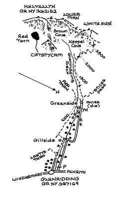
|
Use the Greenside road to
the Youth Hostel and the various buildings that were part of the old lead
mine. Continue upstream on the right bank for a further mile until a
prominent path turns up the fellside. This was the former pony route to the
ridge, and improvements to it have made the ascent pleasant enough if it is
followed all the way. Once the ridge is reached turn right and ascend the
path up to the rocky summit of Raise. Then return to the point of arrival on
the ridge and climb the bank onto White Side. There is little chance of going
astray now as the broad track descends to the depression below Helvellyn
Lower Man, which is gained after a rough stony climb on a narrowing crest.
There is only a slight descent now before the final short ascent to
Helvellyn; the journey being joined by the path from Wythburn. For the return
either Swirral Edge visiting Catstycam and down Red Tarn Beck, or Striding
Edge and Birkhouse Moor descending to Lantys Tarn can be considered.
|
|
----------------
|
ROUTE TWO. HELVELLYN FROM GLENRIDDING VIA
CATSTYCAM.
4 miles 2900ft of ascent. To Catstycam it is 3.25 2450ft of
ascent
|
|
|
|
click to enlarge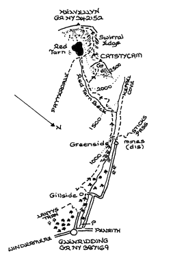
|
For this walk use
the lane on the south or left side of Glenridding Beck, and at the fork in
the track keep to the bank of the stream past a camp site to Rattlebeck
Bridge. Ascend the track left up to the top of the intake wall alongside which
a good path heads up the valley to Greenside. Continue ahead without crossing
the footbridge, and soon the now rebuilt path starts it's climb by Red Tarn
Beck. In clear weather a prominent shoulder will be seen coming down from
Catstycam just before Red Tarn is reached and a path going up it. It is a bit
eroded in places but finishes well with fine views down the valley. If the
clouds are down it might be better to proceed past Red Tarn to the foot of
Swirral Edge, when the track to Catstycam should be seen doubling back along
the ridge. There is a stony descent from Catstycam to the base of Swirral
Edge followed by a steep rough climb. In good conditions it is preferable to
enjoy the scrambling on the crest.
|
|
----------------
|
ROUTE THREE. HELVELLYN FROM PATTERDALE OR
GLENRIDDING VIA KELDAS AND
BIRKHOUSE MOOR.
5.25miles from Patterdale. 3.75 miles from Glenridding 3000ft of
ascent.
|
Ascent Breakdown
|
Distance
|
|
Ascent
|
|
|
|
miles
|
km
|
ft
|
metres
|
|
Patterdale to Keldas.
|
1.5
|
2.4
|
525
|
161
|
|
Glenridding to Keldas.
|
0.75
|
1.2
|
525
|
161
|
|
Keldas to Birkhouse Moor.
|
1.5
|
2.4
|
1400
|
427
|
|
Birkhouse Moor to Helvellyn.
|
1.5
|
2.4
|
875
|
268
|
|
|
|
|
click to enlarge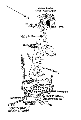
|
From either start the first
objective is Lantys Tarn below Keldas using the good path linking Glenridding and
Grisedale. Take the lane left of Glenridding Beck and at the fork in the track turn
left to gain the path up to the tarn. There is a choice from Patterdale of either
going up the lane from Grisedale Bridge, or using the path behind the Patterdale Hotel
which is also accessible from the public conveniences near the village store. The
path contours the slopes of Arnison Crag and Birks to emerge on the lane just before the gradient
eases. Either way when the valley of Grisedale
opens up go over the bridge, and at the cross wall go through the gate on
the right and so up to the tarn. Before
heading to the main targets it is worth the simple detour to Keldas from which lovely scenes
unfold of the softer side of Lakeland
and Ullswater in contrast to the wilder country that lies ahead. At the
south end of the tarn go up the path by
the wall where stiles allow a crossing by a sheepfold to the Glenridding side. The path is
clear but not well worn until the main track comes in above Mires Beck, and now on a
realigned course the ascent to the flat
top of Birkhouse Moor is plain to follow. Continue along the ridge to the
Hole in the Wall where the usual
direct route from Patterdale comes in, and then the ridge narrows and forms the rocky crest of Striding
Edge. In decent weather there should be no problems if you have a head for heights,
and there is a track just below the crest if preferred. The final scramble to
Helvellyn's summit is steep and badly eroded. Patterdale may be returned to by way of
Grisedale Tarn and Grisedale; while for Glenridding there is the option of descending
Swirral Edge to complete the circuit of Red Tarn. Alternatively the old pony route
beyond White Side down to Glenridding Beck can be adapted.
|
|
----------------
|
ROUTE FOUR. HELVELLYN
FROM PATTERDALE VIA DOLLYWAGGON PIKE AND NETHERMOST PIKE.
5.5miles 3000ft of ascent.
|
Ascent Breakdown
|
Distance
|
Ascent
|
|
miles
|
km
|
ft
|
metres
|
|
Patterdale to Dollywaggon Pike
|
4
|
6.4
|
2400
|
732
|
|
Dollywaggon Pike to Nethermost Pike
|
0.75
|
1.2
|
300
|
91
|
|
Nethermost Pike to Helvellyn.
|
0.75
|
1.2
|
300
|
91
|
|
|
|
|
click to enlarge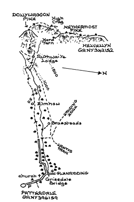
|
Walk up the
Grisedale valley from Grisedale Bridge keeping to the south side past Elmhow
as far as a footbridge below Ruthwaite Lodge (a climbing hut) where cross and
go up to the hut. Here begins the ascent of Dollywaggon Pike's east ridge and
a path to the right of the building rises through the bracken. It is best to
gain the ridge above Spout Crag and a sketchy trod can be followed across.
Until the higher reaches of the ascent where the ridge narrows and the path
becomes clearer there may be some difficulty following it, but always take
the obvious line and signs of previous use will be detected. The scenery and
situations as the summit nears are excellent. As yet the route has not been
trodden to death, and I hope this inclusion of it will not lead to that state
of affairs. Leaving Dollywaggon descend with the escarpment above Ruthwaite
Cove on the right to the junction with the popular route to Helvellyn from
Grisedale Tarn. This should be left almost immediately for a stony track
climbing up to High Crag as this retains the scenery down into the cove. A
simple walk over splendid turf connects with Nethermost Pike though a short
detour east to peer down the ridge is recommended. Also look down to see Hard
Tarn on it's rocky shelf as you leave High Crag. Lastly head north to rejoin
the main path once more at Swallow Scarth , but forsake it again so that the
rim of the escarpment above Striding Edge and Nethermost Cove can be enjoyed.
The summit of Helvellyn high above Red Tarn is now at hand. Enthusiasts for a
touch of drama can descend over Striding Edge, or indeed Swirral Edge to Red
Tarn. In both cases the Hole in the wall on Birkhouse Moor is the objective
for the descent to Patterdale. If a more staid route is needed then return
along the ridge to drop down to Grisedale Tarn.
|
|
----------------
|
ROUTE FIVE. HELVELLYN FROM WYTHBURN VIA NETHERMOST
PIKE.
2.5 miles 2600ft of ascent. To Nethermost Pike it is 1.75 miles
2300ft of ascent.
|
|
|
|
click to enlarge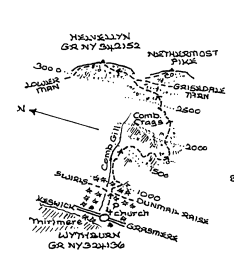
|
Leaving the car
park by Wythburn Church ascend the track in the forest ride and continue
ahead up the path on the other side of the forest road. There is no chance of
going astray now as this stony highway climbs into the recess below Comb
Crags, and then curves round to the right emerging above the declivity onto
the wide expanse of Birk Side. A long steady climb follows before the track
swings left towards Helvellyn. When the gradient levels out leave it to go
directly up the short slope to the flat summit of Nethermost Pike crossing
the track from Grisedale Tarn on the way. Lastly head north to cross the
depression at Swallow Scarth, and then as on Route Four keep to the edge of
the escarpment for the best scenery that Helvellyn has to offer on the
approach to the summit. To make a round of it back to Wythburn go down the
track to Thirlmere at The Swirls, and then take the forest road through the
woods above the road. Midway this becomes a rather rough path before
reverting to the forest road crossed just above the church.
|
|
----------------
|
ROUTE SIX. HELVELLYN FROM THIRLSPOT VIA HELVELLYN
LOWER MAN.
3 miles 2550ft of ascent. To Lower Man it is 2.5 miles 2400ft of
ascent
|
|
|
|
click to enlarge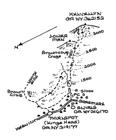
|
Behind the Kings
Head stiles admit entry to the open fell where a track follows the wall on
the left. When the wall bends to the left the old 'White Stones Route' curves
up and round to the right across the hillside. Gradually rising for a full
mile it crosses Helvellyn Gill and joins the nowadays more often used route
starting at The Swirls. On the now renovated track a steep climb lies ahead
to the top of Browncove Crags where more amenable ground leads to the bottom
of the short rise that is Lower Man. The tiny detour should be made for it's
views across Brown Cove to Catstycam before making the ultimate short ascent
onto Helvellyn. A good way back is to go down the ridge from Lower Man to the
depression below White Side where a good path contours the fell to eventually
round Brown Crag and descend to Thirlspot. Adding a bit extra on the top of
White Side may be visited before dropping down the north west shoulder to
link with the afore mentioned path as it nears Brown Crag. As mentioned the popular starting place now is at The Swirls
where there are car parks and toilets.
There are some things it lacks though at the end of a walk that the
Kings Head does provide! It is however a good half a mile shorter to
Helvellyn from The Swirls.
|
|
Copyright (C) 2007 B S Baker
��������������������������������������������������������������������������������������������������������������������������������������������������������������������������������������������������������������������������������������������������������������������������������������������������������������������������������������������������������������������������������������������������������������������������������������������������������������������������������������������������������������������������������������������������������������������������������������������������������������������������������������������������������������������������������������������������������������������������������������������������������������������������������������������������������������������������������������������������������������������������������������������������������������������������������������������������������������������������������������������������������������������������������������������������������������������������������������������������������������������������������������������������������������������������������������������������������������������������������������������������������������������������������������������������������������������������������������������������������������������������������������������������������������������������������������������������������������������������������������������������������������������������������������������������������������������������������������������������������������������������������������������������������������������������������������������������������������������������������������������������������������������������������������������������������������������������������������������������������������������������������������������������������������������������������������������������������������������������������������������������������������������������������������������������������������������������������������������������������������������������������������������������������������������������������������������������������������������������������������������������������������������������������������������������������������������������������������������������������������������������������������������������������������������������������������������������������������������������������������������������������������������������������������������������������������������������������������������������������������������������������������������������������������������������������������������������������������������������������������������������������������������������������������������������������������������������������������������������������������������������������������������������������������������������������������������������������������������������������������������������������������������������������������������������������������������������������������������������������������������������������������������������������������������������������������������������������������������������������������������������������������������������������������������������������������������������������������������������������������������������������������������������������������������������������������������������������������������������������������������������������������������������������������������������������������������������������������������������������������������������������������������������������������������������������������������������������������������������������������������������������������������������������������������������������������������������������������������������������������������������������������������������������������������������������������������������������������������������������������������������������������������������������������������������������������������������������������������������������������������������������������������������������������������������������������������������������������������������������������������������������������������������������������������������������������������������������������������������������������������������������������������������������������������������������������������������������������������������������������������������������������������������������������������������������������������������������������������������������������������������������������������������������������������������������������������������������������������������������������������������������������������������������������������������������������������������������������������������������������������������������������������������������������������������������������������������������������������������������������������������������������������������������������������������������������������������������������������������������������������������������������������������������������������������������������������������������������������������������������������������������������������������������������������������������������������������������������������������������������������������������������������������������������������������������������������������������������������������������������������������������������������������������������������������������������������������������������������������������������������������������������������������������������������������������������������������������������������������������������������������������������������������������������������������������������������������������������������������������������������������������������������������������������������������������������������������������������������������������������������������������������������������������������������������������������������������������������������������������������������������������������������������������������������������������������������������������������������������������������������������������������������������������������������������������������������������������������������������������������������������������������������������������������������������������������������������������������������������������������������������������������������������������������������������������������������������������������������������������������������������������������������������������������������������������������������������������������������������������������������������������������������������������������������������������������������������������������������������������������������������������������������������������������������������������������������������������������������������������������������������������������������������������������������������������������������������������������������������������������������������������������������������������������������������������������������������������������������������������������������������������������������������������������������������������������������������������������������������������������������������������������������������������������������������������������������������������������������������������������������������������������������������������������������������������������������������������������������������������������������������������������������������������������������������������������������������������������������������������������������������������������������������������������������������������������������������������������������������������������������������������������������������������������������������������������������������������������������������������������������������������������������������������������������������������������������������������������������������������������������������������������������������������������������������������������������������������������������������������������������������������������������������������������������������������������������������������������������������������������������������������������������������������������������������������������������������������������������������������������������������������������������������������������������������������������������������������������������������������������������������������������������������������������������������������������������������������������������������������������������������������������������������������������������������������������������������������������������������������������������������������������������������������������������������������������������������������������������������������������������������������������������������������������������������������������������������������������������������������������������������������������������������������������������������������������������������������������������������������������������������������������������������������������������������������������������������������������������������������������������������������������������������������������������������������������������������������������������������������������������������������������������������������������������������������������������������������������������������������������������������������������������������������������������������������������������������������������������������������������������������������������������������������������������������������������������������������������������������������������������������������������������������������������������������������������������������������������������������������������������������������������������������������������������������������������������������������������������������������������������������������������������������������������������������������������������������������������������������������������������������������������������������������������������������������������������������������������������������������������������������������������������������������������������������������������������������������������������������������������������������������������������������������������������������������������������������������������������������������������������������������������������������������������������������������������������������������������������������������������������������������������������������������������������������������������������������������������������������������������������������������������������������������������������������������������������������������������������������������������������������������������������������������������������������������������������������������������������������������������������������������������������������������������������������������������������������������������������������������������������������������������������������������������������������������������������������������������������������������������������������������������������������������������������������������������������������������������������������������������������������������������������������������������������������������������������������������������������������������������������������������������������������������������������������������������������������������������������������������������������������������������������������������������������������������������������������������������������������������������������������������������������������������������������������������������������������������������������������������������������������������������������������������������������������������������������������������������������������������������������������������������������������������������������������������������������������������������������������������������������������������������������������������������������������������������������������������������������������������������������������������������������������������������������������������������������������������������������������������������������������������������������������������������������������������������������������������������������������������������������������������������������������������������������������������������������������������������������������������������������������������������������������������������������������������������������������������������������������������������������������������������������������������������������������������������������������������������������������������������������������������������������������������������������������������������������������������������������������������������������������������������������������������������������������������������������������������������������������������������������������������������������������������������������������������������������������������������������������������������������������������������������������������������������������������������������������������������������������������������������������������������������������������������������������������������������������������������������������������������������������������������������������������������������������������������������������������������������������������������������������������������������������������������������������������������������������������������������������������������������������������������������������������������������������������������������������������������������������������������������������������������������������������������������������������������������������������������������������������������������������������������������������������������������������������������������������������������������������������������������������������������������������������������������������������������������������������������������������������������������������������������������������������������������������������������������������������������������������������������������������������������������������������������������������������������������������������������������������������������������������������������������������������������������������������������������������������������������������������������������������������������������������������������������������������������������������������������������������������������������������������������������������������������������������������������������������������������������������������������������������������������������������������������������������������������������������������������������������������������������������������������������������������������������������������������������������������������������������������������������������������������������������������������������������������������������������������������������������������������������������������������������������������������������������������������������������������������������������������������������������������������������������������������������������������������������������������������������������������������������������������������������������������������������������������������������������������������������������������������������������������������������������������������������������������������������������������������������������������������������������������������������������������������������������������������������������������������������������������������������������������������������������������������������������������������������������������������������������������������������������������������������������������������������������������������������������������������������������������������������������������������������������������������������������������������������������������������������������������������������������������������������������������������������������������������������������������������������������������������������������������������������������������������������������������������������������������������������������������������������������������������������������������������������������������������������������������������������������������������������������������������������������������������������������������������������������������������������������������������������������������������������������������������������������������������������������������������������������������������������������������������������������������������������������������������������������������������������������������������������������������������������������������������������������������������������������������������������������������������������������������������������������������������������������������������������������������������������������������������������������������������������������������������������������������������������������������������������������������������������������������������������������������������������������������������������������������������������������������������������������������������������������������������������������������������������������������������������������������������������������������������������������������������������������������������������������������������������������������������������������������������������������������������������������������������������������������������������������������������������������������������������������������������������������������������������������������������������������������������������������������������������������������������������������������������������������������������������������������������������������������������������������������������������������������������������������������������������������������������������������������������������������������������������������������������������������������������������������������������������������������������������������������������������������������������������������������������������������������������������������������������������������������������������������������������������������������������������������������������������������������������������������������������������������������������������������������������������������������������������������������������������������������������������������������������������������������������������������������������������������������������������������������������������������������������������������������������������������������������������������������������������������������������������������������������������������������������������������������������������������������������������������������������������������������������������������������������������������������������������������������������������������������������������������������������������������������������������������������������������������������������������������������������������������������������������������������������������������������������������������������������������������������������������������������������������������������������������������������������������������������������������������������������������������������������������������������������������������������������������������������������������������������������������������������������������������������������������������������������������������������������������������������������������������������������������������������������������������������������������������������������������������������������������������������������������������������������������������������������������������������������������������������������������������������������������������������������������������������������������������������������������������������������������������������������������������������������������������������������������������������������������������������������������������������������������������������������������������������������������������������������������������������������������������������������������������������������������������������������������������������������������������������������������������������������������������������������������������������������������������������������������������������������������������������������������������������������������������������������������������������������������������������������������������������������������������������������������������������������������������������������������������������������������������������������������������������������������������������������������������������������������������������������������������������������������������������������������������������������������������������������������������������������������������������������������������������������������������������������������������������������������������������������������������������������������������������������������������������������������������������������������������������������������������������������������������������������������������������������������������������������������������������������������������������������������������������������������������������������������������������������������������������������������������������������������������������������������������������������������������������������������������������������������������������������������������������������������������������������������������������������������������������������������������������������������������������������������������������������������������������������������������������������������������������������������������������������������������������������������������������������������������������������������������������������������������������������������������������������������������������������������������������������������������������������������������������������������������������������������������������������������������������������������������������������������������������������������������������������������������������������������������������������������������������������������������������������������������������������������������������������������������������������������������������������������������������������������������������������������������������������������������������������������������������������������������������������������������������������������������������������������������������������������������������������������������������������������������������������������������������������������������������������������������������������������������������������������������������������������������������������������������������������������������������������������������������������������������������������������������������������������������������������������������������������������������������������������������������������������������������������������������������������������������������������������������������������������������������������������������������������������������������������������������������������������������������������������������������������������������������������������������������������������������������������������������������������������������������������������������������������������������������������������������������������������������������������������������������������������������������������������������������������������������������������������������������������������������������������������������������������������������������������������������������������������������������������������������������������������������������������������������������������������������������������������������������������������������������������������������������������������������������������������������������������������������������������������������������������������������������������������������������������������������������������������������������������������������������������������������������������������������������������������������������������������������������������������������������������������������������������������������������������������������������������������������������������������������������������������������������������������������������������������������������������������������������������������������������������������������������������������������������������������������������������������������������������������������������������������������������������������������������������������������������������������������������������������������������������������������������������������������������������������������������������������������������������������������������������������������������������������������������������������������������������������������������������������������������������������������������������������������������������������������������������������������������������������������������������������������������������������������������������������������������������������������������������������������������������������������������������������������������������������������������������������������������������������������������������������������������������������������������������������������������������������������������������������������������������������������������������������������������������������������������������������������������������������������������������������������������������������������������������������������������������������������������������������������������������������������������������������������������������������������������������������������������������������������������������������������������������������������������������������������������������������������������������������������������������������������������������������������������������������������������������������������������������������������������������������������������������������������������������������������������������������������������������������������������������������������������������������������������������������������������������������������������������������������������������������������������������������������������������������������������������������������������������������������������������������������������������������������������������������������������������������������������������������������������������������������������������������������������������������������������������������������������������������������������������������������������������������������������������������������������������������������������������������������������������������������������������������������������������������������������������������������������������������������������������������������������������������������������������������������������������������������������������������������������������������������������������������������������������������������������������������������������������������������������������������������������������������������������������������������������������������������������������������������������������������������������������������������������������������������������������������������������������������������������������������������������������������������������������������������������������������������������������������������������������������������������������������������������������������������������������������������������������������������������������������������������������������������������������������������������������������������������������������������������������������������������������������������������������������������������������������������������������������������������������������������������������������������������������������������������������������������������������������������������������������������������������������������������������������������������������������������������������������������������������������������������������������������������������������������������������������������������������������������������������������������������������������������������������������������������������������������������������������������������������������������������������������������������������������������������������������������������������������������������������������������������������������������������������������������������������������������������������������������������������������������������������������������������������������������������������������������������������������������������������������������������������������������������������������������������������������������������������������������������������������������������������������������������������������������������������������������������������������������������������������������������������������������������������������������������������������������������������������������������������������������������������������������������������������������������������������������������������������������������������������������������������������������������������������������������������������������������������������������������������������������������������������������������������������������������������������������������������������������������������������������������������������������������������������������������������������������������������������������������������������������������������������������������������������������������������������������������������������������������������������������������������������������������������������������������������������������������������������������������������������������������������������������������������������������������������������������������������������������������������������������������������������������������������������������������������������������������������������������������������������������������������������������������������������������������������������������������������������������������������������������������������������������������������������������������������������������������������������������������������������������������������������������������������������������������������������������������������������������������������������������������������������������������������������������������������������������������������������������������������������������������������������������������������������������������������������������������������������������������������������������������������������������������������������������������������������������������������������������������������������������������������������������������������������������������������������������������������������������������������������������������������������������������������������������������������������������������������������������������������������������������������������������������������������������������������������������������������������������������������������������������������������������������������������������������������������������������������������������������������������������������������������������������������������������������������������������������������������������������������������������������������������������������������������������������������������������������������������������������������������������������������������������������������������������������������������������������������������������������������������������������������������������������������������������������������������������������������������������������������������������������������������������������������������������������������������������������������������������������������������������������������������������������������������������������������������������������������������������������������������������������������������������������������������������������������������������������������������������������������������������������������������������������������������������������������������������������������������������������������������������������������������������������������������������������������������������������������������������������������������������������������������������������������������������������������������������������������������������������������������������������������������������������������������������������������������������������������������������������������������������������������������������������������������������������������������������������������������������������������������������������������������������������������������������������������������������������������������������������������������������������������������������������������������������������������������������������������������������������������������������������������������������������������������������������������������������������������������������������������������������������������������������������������������������������������������������������������������������������������������������������������������������������������������������������������������������������������������������������������������������������������������������������������������������������������������������������������������������������������������������������������������������������������������������������������������������������������������������������������������������������������������������������������������������������������������������������������������������������������������������������������������������������������������������������������������������������������������������������������������������������������������������������������������������������������������������������������������������������������������������������������������������������������������������������������������������������������������������������������������������������������������������������������������������������������������������������������������������������������������������������������������������������������������������������������������������������������������������������������������������������������������������������������������������������������������������������������������������������������������������������������������������������������������������������������������������������������������������������������������������������������������������������������������������������������������������������������������������������������������������������������������������������������������������������������������������������������������������������������������������������������������������������������������������������������������������������������������������������������������������������������������������������������������������������������������������������������������������������������������������������������������������������������������������������������������������������������������������������������������������������������������������������������������������������������������������������������������������������������������������������������������������������������������������������������������������������������������������������������������������������������������������������������������������������������������������������������������������������������������������������������������������������������������������������������������������������������������������������������������������������������������������������������������������������������������������������������������������������������������������������������������������������������������������������������������������������������������������������������������������������������������������������������������������������������������������������������������������������������������������������������������������������������������������������������������������������������������������������������������������������������������������������������������������������������������������������������������������������������������������������������������������������������������������������������������������������������������������������������������������������������������������������������������������������������������������������������������������������������������������������������������������������������������������������������������������������������������������������������������������������������������������������������������������������������������������������������������������������������������������������������������������������������������������������������������������������������������������������������������������������������������������������������������������������������������������������������������������������������������������������������������������������������������������������������������������������������������������������������������������������������������������������������������������������������������������������������������������������������������������������������������������������������������������������������������������������������������������������������������������������������������������������������������������������������������������������������������������������������������������������������������������������������������������������������������������������������������������������������������������������������������������������������������������������������������������������������������������������������������������������������������������������������������������������������������������������������������������������������������������������������������������������������������������������������������������������������������������������������������������������������������������������������������������������������������������������������������������������������������������������������������������������������������������������������������������������������������������������������������������������������������������������������������������������������������������������������������������������������������������������������������������������������������������������������������������������������������������������������������������������������������������������������������������������������������������������������������������������������������������������������������������������������������������������������������������������������������������������������������������������������������������������������������������������������������������������������������������������������������������������������������������������������������������������������������������������������������������������������������������������������������������������������������������������������������������������������������������������������������������������������������������������������������������������������������������������������������������������������������������������������������������������������������������������������������������������������������������������������������������������������������������������������������������������������������������������������������������������������������������������������������������������������������������������������������������������������������������������������������������������������������������������������������������������������������������������������������������������������������������������������������������������������������������������������������������������������������������������������������������������������������������������������������������������������������������������������������������������������������������������������������������������������������������������������������������������������������������������������������������������������������������������������������������������������������������������������������������������������������������������������������������������������������������������������������������������������������������������������������������������������������������������������������������������������������������������������������������������������������������������������������������������������������������������������������������������������������������������������������������������������������������������������������������������������������������������������������������������������������������������������������������������������������������������������������������������������������������������������������������������������������������������������������������������������������������������������������������������������������������������������������������������������������������������������������������������������������������������������������������������������������������������������������������������������������������������������������������������������������������������������������������������������������������������������������������������������������������������������������������������������������������������������������������������������������������������������������������������������������������������������������������������������������������������������������������������������������������������������������������������������������������������������������������������������������������������������������������������������������������������������������������������������������������������������������������������������������������������������������������������������������������������������������������������������������������������������������������������������������������������������������������������������������������������������������������������������������������������������������������������������������������������������������������������������������������������������������������������������������������������������������������������������������������������������������������������������������������������������������������������������������������������������������������������������������������������������������������������������������������������������������������������������������������������������������������������������������������������������������������������������������������������������������������������������������������������������������������������������������������������������������������������������������������������������������������������������������������������������������������������������������������������������������������������������������������������������������������������������������������������������������������������������������������������������������������������������������������������������������������������������������������������������������������������������������������������������������������������������������������������������������������������������������������������������������������������������������������������������������������������������������������������������������������������������������������������������������������������������������������������������������������������������������������������������������������������������������������������������������������������������������������������������������������������������������������������������������������������������������������������������������������������������������������������������������������������������������������������������������������������������������������������������������������������������������������������������������������������������������������������������������������������������������������������������������������������������������������������������������������������������������������������������������������������������������������������������������������������������������������������������������������������������������������������������������������������������������������������������������������������������������������������������������������������������������������������������������������������������������������������������������������������������������������������������������������������������������������������������������������������������������������������������������������������������������������������������������������������������������������������������������������������������������������������������������������������������������������������������������������������������������������������������������������������������������������������������������������������������������������������������������������������������������������������������������������������������������������������������������������������������������������������������������������������������������������������������������������������������������������������������������������������������������������������������������������������������������������������������������������������������������������������������������������������������������������������������������������������������������������������������������������������������������������������������������������������������������������������������������������������������������������������������������������������������������������������������������������������������������������������������������������������������������������������������������������������������������������������������������������������������������������������������������������������������������������������������������������������������������������������������������������������������������������������������������������������������������������������������������������������������������������������������������������������������������������������������������������������������������������������������������������������������������������������������������������������������������������������������������������������������������������������������������������������������������������������������������������������������������������������������������������������������������������������������������������������������������������������������������������������������������������������������������������������������������������������������������������������������������������������������������������������������������������������������������������������������������������������������������������������������������������������������������������������������������������������������������������������������������������������������������������������������������������������������������������������������������������������������������������������������������������������������������������������������������������������������������������������������������������������������������������������������������������������������������������������������������������������������������������������������������������������������������������������������������������������������������������������������������������������������������������������������������������������������������������������������������������������������������������������������������������������������������������������������������������������������������������������������������������������������������������������������������������������������������������������������������������������������������������������������������������������������������������������������������������������������������������������������������������������������������������������������������������������������������������������������������������������������������������������������������������������������������������������������������������������������������������������������������������������������������������������������������������������������������������������������������������������������������������������������������������������������������������������������������������������������������������������������������������������������������������������������������������������������������������������������������������������������������������������������������������������������������������������������������������������������������������������������������������������������������������������������������������������������������������������������������������������������������������������������������������������������������������������������������������������������������������������������������������������������������������������������������������������������������������������������������������������������������������������������������������������������������������������������������������������������������������������������������������������������������������������������������������������������������������������������������������������������������������������������������������������������������������������������������������������������������������������������������������������������������������������������������������������������������������������������������������������������������������������������������������������������������������������������������������������������������������������������������������������������������������������������������������������������������������������������������������������������������������������������������������������������������������������������������������������������������������������������������������������������������������������������������������������������������������������������������������������������������������������������������������������������������������������������������������������������������������������������������������������������������������������������������������������������������������������������������������������������������������������������������������������������������������������������������������������������������������������������������������������������������������������������������������������������������������������������������������������������������������������������������������������������������������������������������������������������������������������������������������������������������������������������������������������������������������������������������������������������������������������������������������������������������������������������������������������������������������������������������������������������������������������������������������������������������������������������������������������������������������������������������������������������������������������������������������������������������������������������������������������������������������������������������������������������������������������������������������������������������������������������������������������������������������������������������������������������������������������������������������������������������������������������������������������������������������������������������������������������������������������������������������������������������������������������������������������������������������������������������������������������������������������������������������������������������������������������������������������������������������������������������������������������������������������������������������������������������������������������������������������������������������������������������������������������������������������������������������������������������������������������������������������������������������������������������������������������������������������������������������������������������������������������������������������������������������������������������������������������������������������������������������������������������������������������������������������������������������������������������������������������������������������������������������������������������������������������������������������������������������������������������������������������������������������������������������������������������������������������������������������������������������������������������������������������������������������������������������������������������������������������������������������������������������������������������������������������������������������������������������������������������������������������������������������������������������������������������������������������������������������������������������������������������������������������������������������������������������������������������������������������������������������������������������������������������������������������������������������������������������������������������������������������������������������������������������������������������������������������������������������������������������������������������������������������������������������������������������������������������������������������������������������������������������������������������������������������������������������������������������������������������������������������������������������������������������������������������������������������������������������������������������������������������������������������������������������������������������������������������������������������������������������������������������������������������������������������������������������������������������������������������������������������������������������������������������������������������������������������������������������������������������������������������������������������������������������������������������������������������������������������������������������������������������������������������������������������������������������������������������������������������������������������������������������������������������������������������������������������������������������������������������������������������������������������������������������������������������������������������������������������������������������������������������������������������������������������������������������������������������������������������������������������������������������������������������������������������������������������������������������������������������������������������������������������������������������������������������������������������������������������������������������������������������������������������������������������������������������������������������������������������������������������������������������������������������������������������������������������������������������������������������������������������������������������������������������������������������������������������������������������������������������������������������������������������������������������������������������������������������������������������������������������������������������������������������������������������������������������������������������������������������������������������������������������������������������������������������������������������������������������������������������������������������������������������������������������������������������������������������������������������������������������������������������������������������������������������������������������������������������������������������������������������������������������������������������������������������������������������������������������������������������������������������������������������������������������������������������������������������������������������������������������������������������������������������������������������������������������������������������������������������������������������������������������������������������������������������������������������������������������������������������������������������������������������������������������������������������������������������������������������������������������������������������������������������������������������������������������������������������������������������������������������������������������������������������������������������������������������������������������������������������������������������������������������������������������������������������������������������������������������������������������������������������������������������������������������������������������������������������������������������������������������������������������������������������������������������������������������������������������������������������������������������������������������������������������������������������������������������������������������������������������������������������������������������������������������������������������������������������������������������������������������������������������������������������������������������������������������������������������������������������������������������������������������������������������������������������������������������������������������������������������������������������������������������������������������������������������������������������������������������������������������������������������������������������������������������������������������������������������������������������������������������������������������������������������������������������������������������������������������������������������������������������������������������������������������������������������������������������������������������������������������������������������������������������������������������������������������������������������������������������������������������������������������������������������������������������������������������������������������������������������������������������������������������������������������������������������������������������������������������������������������������������������������������������������������������������������������������������������������������������������������������������������������������������������������������������������������������������������������������������������������������������������������������������������������������������������������������������������������������������������������������������������������������������������������������������������������������������������������������������������������������������������������������������������������������������������������������������������������������������������������������������������������������������������������������������������������������������������������������������������������������������������������������������������������������������������������������������������������������������������������������������������������������������������������������������������������������������������������������������������������������������������������������������������������������������������������������������������������������������������������������������������������������������������������������������������������������������������������������������������������������������������������������������������������������������������������������������������������������������������������������������������������������������������������������������������������������������������������������������������������������������������������������������������������������������������������������������������������������������������������������������������������������������������������������������������������������������������������������������������������������������������������������������������������������������������������������������������������������������������������������������������������������������������������������������������������������������������������������������������������������������������������������������������������������������������������������������������������������������������������������������������������������������������������������������������������������������������������������������������������������������������������������������������������������������������������������������������������������������������������������������������������������������������������������������������������������������������������������������������������������������������������������������������������������������������������������������������������������������������������������������������������������������������������������������������������������������������������������������������������������������������������������������������������������������������������������������������������������������������������������������������������������������������������������������������������������������������������������������������������������������������������������������������������������������������������������������������������������������������������������������������������������������������������������������������������������������������������������������������������������������������������������������������������������������������������������������������������������������������������������������������������������������������������������������������������������������������������������������������������������������������������������������������������������������������������������������������������������������������������������������������������������������������������