GRASMOOR, CRAG HILL AND GRISEDALE PIKE
|
This
fine group of fells is clearly defined by natural boundaries. It has the
Newlands Valley and Braithwaite on the eastern side, while Lorton Vale and Crummock
Water form the western one. The road from Buttermere to Keswick over Newlands
Hause marks the southern limits, and Whinlatter Pass between Lorton and
Braithwaite the northern. These hills have a character all of their own
rising steeply from the surrounding valleys as though to fully utilise the
space within. The result is a compact mass of summits notable for the most
part in their narrow connecting ridges; which provide relatively firm walking
even after a spell of wet weather. Most seasoned walkers have a high regard
for them, and look forward to a day in their company. Grasmoor is the highest
point hereabouts, and it differs from the others in that it is a bulky fell
yet is rarely dominant from the nearest of it's neighbours . It is best appreciated
from further afield as seen from the Loweswater hills or the High Stile
ridge. Moor seems to aptly describe the summit, but the great scoop of Dove
Crags above Gasgale Gill bites deeply into it, and the views from here and
over Crummock Water on the other side are superb. A high saddle links
Grasmoor to the main cluster of hills of which Crag Hill is the hub and only
just inferior in height. One of the best loved ridges in the district
descends from Crag Hill over Sail and Scar Crags to the curious top of Causey
Pike; one of those fells instantly recognised in a view. Another fine ridge
descends over Wandope and Thirdgill Head Man to the shapely peak of Whiteless
Pike before descending to Buttermere. To the north of Crag Hill another high
saddle between Coledale and Gasgale Gill connects with the three grand hills
above Whinlatter Pass; the central summit where the ridges join being
Hopegill Head. A walk of high quality on a narrow crest leads to Whiteside
above Lorton, and another enjoyable ridge goes east round the Hobcarton
Valley to Grisedale Pike whose spire like cone is in view from Keswick. North
of Hopegill Head a short and rough descent on exposed slate leads to Ladyside
Pike, and then over Swinside down to Lorton. The best is not always the highest,
and here are perfect examples of that. Barrow above Braithwaite and Newlands
which has wonderful views over Derwent Water and of Skiddaw is one. Another
one is Rannerdale Knotts above Crummock Water; a little ridge that is
absolutely delightful.
|
|
|
|
|
----------------
|
ROUTE ONE. CRAG HILL (Eel Crag) FROM
LANTHWAITE GREEN VIA WHITESIDE AND HOPEGILL HEAD.
4 miles 3100ft of ascent.
|
Ascent Breakdown
|
Distance
|
Ascent
|
|
miles
|
km
|
ft
|
metres
|
|
Lanthwaite Green to Whiteside.
|
1.25
|
2
|
1850
|
564
|
|
Whiteside to Hopegill Head.
|
1
|
1.6
|
400
|
122
|
|
Hopegill Head to Crag Hill
|
1.75
|
2.8
|
850
|
259
|
|
|
|
|
click to enlarge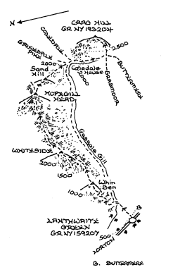
|
A signpost opposite the
small car park at Lanthwaite Green points the way to Gasgale Gill and
Whiteside. The climb starts after the footbridge has been crossed first going
left a little to gain a footing on the steep bank. A well used path becoming
very eroded ascends the appropriately named Whin Ben, after which an easier
section leads to the final long rough and rocky slope. Careful selection of
the way ahead pays dividends here as the wide trail offers a choice of route.
The summit of Whiteside is a welcome relief, and the view along the face of
Gasgale Crags towards Hopegill Head is a gem. So is the ridge ahead over the higher
top, and on a narrow crest to and beyond the main depression. The summit of
Hopegill Head is one of the very best poised high above the valley from which
it gets it's name, and also on the very brink of Hobcarton Crag. Head
slightly east of south now to the subsidiary top of Sand Hill and go down the
shoulder to Coledale Hause. A direct ascent of Crag Hill may be attempted
here, but walkers who care about the damage done on scree slopes such as this
will continue ahead between Crag Hill and Grasmoor to the head of Gasgale
Gill, and then turn left for the summit from there. Also worth considering at
Coledale Hause is to add Grasmoor to the walk. Cross Gasgale Gill and ascend
the obvious ridge taking shape there on a good path that curves up to the rim
of Dove Crags; a feature missed by many visitors to the fell. From the summit
shelter the main path can then be followed with a grand view down to Crummock
Water back to the head of Gasgale Gill. The finest way down is by the
Whiteless Pike ridge and down the little Rannerdale Valley, best seen at
bluebell time, leaving a mile or so by the road back to the start. Rannerdale
Knotts can be added and should be if time permits.
|
|
----------------
|
ROUTE TWO. CRAG HILL (Eel
Crag) FROM HIGH LORTON VIA LADYSIDE PIKE AND HOPEGILL HEAD.
5.5 miles 3200ft of ascent.
|
Ascent Breakdown
|
Distance
|
Ascemt
|
|
miles
|
km
|
ft
|
metres
|
|
High Lorton to Ladyside Pike.
|
3.25
|
5.2
|
2025
|
617
|
|
Ladyside Pike to Hopegill Head.
|
0.5
|
0.8
|
325
|
99
|
|
Hopegill Head to Crag Hill.
|
1.75
|
2.8
|
850
|
259
|
|
|
|
|
click to enlarge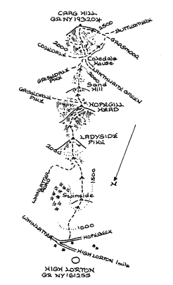
|
Leave High Lorton
on the lane to Boonbeck and Scales, and stay with it to the junction with the
lane from Hopebeck. Turn along this lane and pass through a gate on the left
just beyond the third enclosure fence to another gate at the top of the
enclosure. The way ahead is now clear to the shoulder of Swinside, and a long
steady climb follows without incident to Ladyside Pike where matters improve
markedly. The summit has two cairns and some small pits, but the main
attention now will be ahead to the naked rock ridge below Hopegill Head. The
path first rounds a small rise and just above a tiny detour left will lead to
a doorway on the rim of Hobcarton Crag. Easily negotiable rock slabs are now
climbed to the summit cairn, but under snow or icy conditions this is a
difficult place to be without the appropriate equipment. The route now
coincides with that described in Route One. If a return has to be made to
Lorton there is no obvious easy alternative. To avoid further climbing a
descent of Gasgale Gill to Lanthwaite Green is a possibility thence following
the intakes back to Lorton. If Hopegill Head can be tackled once more then
the ridge to Whiteside may be enjoyed before dropping down the shoulder from
the higher top to Dodd and Hope Beck. Another car in Buttermere or the bus
service back to Lorton from there is perhaps the best plan.
|
|
----------------
|
ROUTE THREE. CRAG
HILL (Eel Crag) FROM BRAITHWAITE VIA KINN AND GRISEDALE PIKE
4.75 miles 3400ft of ascent.
|
Ascent Breakdown
|
Distance
|
Ascent
|
|
miles
|
km
|
ft
|
metres
|
|
Braithwaite to Kinn
|
1
|
1.6
|
950
|
290
|
|
Kinn to Grisedale Pike
|
1.5
|
2.4
|
1425
|
434
|
|
Grisedale Pike to Crag Hill.
|
2.25
|
3.6
|
1025
|
312
|
|
|
|
|
click to enlarge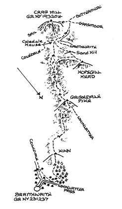
|
Walk up the Whinlatter Pass
road to the end of the Coledale mine track where a few cars may be parked.
The ascent starts here up some steps, and once underway the rest of the
ascent over Kinn to Grisedale Pike is obvious. Apart from Kinn there are two
more well defined ascents the first to Sleet How and then the slaty narrower
ridge to the Pike. Now go down the south west ridge, and over a subsidiary
top bearing left immediately down to Coledale Hause where Routes One and Two
are joined. Follow Gasgale Gill to it's source at the col between Grasmoor
and Crag Hill there turning left up to the summit. The royal road back to
Braithwaite must be by Route Four down the east ridge over Sail. There are
several choices on the way; the easiest being to descend left at Sail Pass
and go down Stoneycroft Gill to pass through Barrow Door between Stile End
and Barrow. If at all possible Barrow at least should be traversed, and the
options of adding Outerside and even Causey Pike to complete the Coledale
Horseshoe are there too.
|
|
----------------
|
ROUTE FOUR. CRAG HILL (Eel Crag) FROM BRAITHWAITE
VIA BARROW, STILE END, OUTERSIDE AND SAIL.
4.25 miles 3150ft of ascent.
|
Ascent Breakdown
|
Distance
|
Ascent
|
|
miles
|
km
|
ft
|
metres
|
|
Braithwaite to Barrow
|
1.5
|
2.4
|
1225
|
373
|
|
Barrow to Stile End.
|
0.5
|
0.8
|
200
|
61
|
|
Stile End to Outerside
|
0.75
|
1.2
|
500
|
152
|
|
Outerside to Sail
|
1
|
1.6
|
900
|
274
|
|
Sail to Crag Hill.
|
0.5
|
0.8
|
325
|
99
|
|
|
|
|
click to enlarge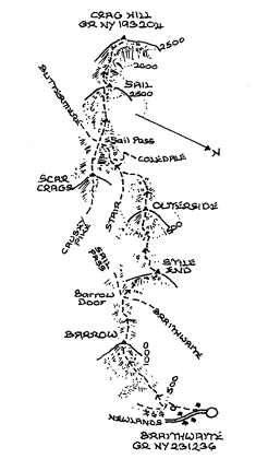
|
The wide path up
the north east ridge of Barrow is clearly seen from Braithwaite. Go by the
village shop along the Newlands road, and where it turns left keep ahead up
the farm track to Braithwaite Lodge. Two stiles provide access to the open
fell and the rising ridge. This is a lovely climb with grand views back to
Skiddaw and across to Derwent Water. The upper slopes are cloaked in heather
as is a large part of the next stage to Stile End. Go down the ridge to
Barrow Door and bear right above
the Door for Stile End. Descend the short south western slope and cross the
spongy Low Moss to the foot of Outerside where a somewhat worn path winds up
the heathery ridge to the top. There is a fine view ahead to Crag Hill here
and the Force Crag Mine is just below in Coledale. Go down to High Moss to
meet the Stoneycroft Gill mine road where those who wish to do so can
diagonally cross the fellside on a quite recently formed path to Causey Pike,
and link with Route Five from Stair. Otherwise turn right along the track
which soon ascends through the debris of a disused mine below Scar Crags.
Sail Pass will gratefully be reached, but the long climb up to Sail now lies
ahead. The cairn on Sail lies within a small pool and few people turn aside
to visit it. Instead they remain on the path as it makes a short descent on a
narrow crest and finally up the facing rocky rib to the broad summit of Crag
Hill. The views are grand all round but especially that back down the ridge
to Causey Pike and of Coledale way below. If this route was the best way back
to Braithwaite on Route Three, then Route Three is the best way back now.
Grasmoor, Wandope and Hopegill Head can all be added to the round, but
otherwise turn down into the headwaters of Gasgale Gill to Coledale Hause.
Take the path to the right of Sand Hill for Grisedale Pike, or should an
early descent be required turn down immediately right for Coledale.
|
|
----------------
|
ROUTE FIVE. CRAG HILL
FROM STAIR VIA CAUSEY PIKE, SCAR CRAGS AND SAIL.
3.5 miles 2900ft of ascent.
|
Ascent Breakdown
|
Distance
|
Ascent
|
|
miles
|
km
|
ft
|
metres
|
|
Stair to Causey Pike.
|
1.5
|
2.4
|
1800
|
549
|
|
Causey Pike to Scar Crags
|
0.75
|
1.2
|
275
|
84
|
|
Scar Crags to Sail.
|
0.75
|
1.2
|
500
|
152
|
|
Sail to Crag Hill.
|
0.5
|
0.8
|
325
|
99
|
|
|
|
|
click to enlarge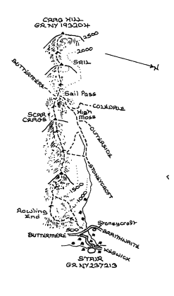
|
This route to Crag
Hill is a great favourite, and the path up the ridge is testimony to it's
popularity. From Stair go up the road and double back at the junction to
Stoneycroft Gill where the ascent begins. The curving ridge up to Rowling End
is an early test of stamina, and may be avoided by using a path slanting up
the northern flank above Stoneycroft Gill. Both routes converge on Sleet
Hause above which a steep narrowing ridge leads up to a final rock band that
proves easier than it looks. The summit is small in area though in fact it is
the first of several humps on this unique top. The continuing ridge to Scar
Crags is a joy to follow with fine views down the face to Rigg Beck and the
remains of the old Oak woodlands that once cloaked these fells. I do think
that they deserve some protection from the grazing sheep. On Scar Crags the
ridge widens prior to dropping down to Sail Pass where Route Four is joined.
The facing slope to Sail is a toil rather than a pleasure, but the ridge from
Sail to Crag Hill is worth the effort. The simplest way back to Stair is to
return to Sail Pass below Scar Crags, and turn down left for the Stoneycroft
Gill mine road. Another option is to go down right from the pass and descend
into Rigg Beck. If a little energy is left ascend the fellside to Ard Crags
and descend to Rigg Beck from there.
|
|
----------------
|
ROUTE SIX. CRAG HILL (Eel
Crag) FROM NEWLANDS HAUSE VIA KNOTT RIGG, ARD CRAGS AND SAIL.
3.5 miles 2350ft of ascent.
|
Ascent Breakdown
|
Distance
|
Ascent
|
|
miles
|
km
|
ft
|
metres
|
|
Newlands Hause to Knott Rigg
|
1
|
1.6
|
750
|
229
|
|
Knott Rigg to Ard Crags.
|
0.75
|
1.2
|
250
|
76
|
|
Ard Crags to Sail.
|
1.25
|
2
|
1025
|
312
|
|
Sail to Crag Hill.
|
0.5
|
0.8
|
325
|
99
|
|
|
|
|
click to enlarge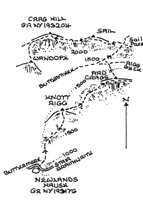
|
An elevated
start is the benefit of this route though other than returning the same way
it would seem more suitable if transport can be laid on elsewhere; perhaps
down in Buttermere. Not that the climbing or the mileage is excessive to walk
back to the hause. The initial climb to Knott Rigg is a test of will, but
having arrived on the narrow crest this is a delightful ridge. Wandope and
Crag Hill dominate it on the left; while across Newlands Pass Robinson
displays it's finest aspect. Ard Crags is one of the prime summits to visit
when the heather is in bloom decorating the rocks in the gully falling to
Keskadale Farm. Leave Ard Crags down the grassy north western slope aiming
for the col between Rigg Beck and Sail Beck. Keep ahead up the opposite slope
joining the path from Sail Beck to Sail Pass. At the pass turn up left and
resolutely climb up to Sail beyond which a much more rewarding ridge connects
with Crag Hill becoming a narrow rocky crest.
|
|
----------------
|
ROUTE SEVEN. CRAG HILL FROM BUTTERMERE VIA
RANNERDALE KNOTTS, WHITELESS PIKE AND WANDOPE.
4.75 miles 2875ft of ascent.
|
Ascent Breakdown
|
Distance
|
Ascent
|
|
miles
|
km
|
ft
|
metres
|
|
Buttermere to Rannerdale Knotts.
|
1.5
|
2.4
|
850
|
259
|
|
Rannerdale Knotts to Whiteless Pike.
|
2
|
3.2
|
1200
|
366
|
|
Whiteless Pike to Wandope.
|
0.75
|
1.2
|
500
|
152
|
|
Wandope to Crag Hill.
|
0.5
|
0.8
|
325
|
99
|
|
|
|
|
click to enlarge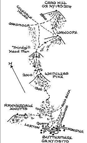
|
The ascent starts
opposite the Bridge Hotel by the side of Mill Beck or opposite the National
Trust car park. Either way the path climbing the rock outcropping ridge to
the end of Low Bank will be met. The ridge leading to Rannerdale Knotts may
be considered a detour, but nothing better will be done and nothing finer
seen later on than from here. The view over Crummock Water from the
delightful summit of the Knott to Mellbreak is a stunner. Having done that
turn up the path winding up the bank on the left. After an easier section
midway a long climb with some erosion to contend with is required to reach
Whiteless Pike. A little loss of height to Saddle Gate is succeeded by a
climb up Whiteless Edge to Thirdgill Head. Beyond the cairn watch for a path
trending right to Wandope. The last part a circuit of Addacombe Hole to Crag
Hill is excellent. Grasmoor should be slotted into this walk if at all
possible; preferably after visiting Wandope. The path to it is clearly
visible from Wandope, and once on the broad top keep to the Crummock Water
side on the way to the summit shelter. Coming back have a look over the rim
of Dove Crags on the north east side of the ridge. If Grasmoor has been
included before arriving on Crag Hill then a descent can be made over Sail to
Sail Pass; there turning down right into the valley of Sail Beck.
|
|
----------------
|
ROUTE EIGHT. CRAG HILL FROM RANNERDALE VIA LAD
HOWS AND GRASMOOR. 2.75 miles 2825ft of ascent. 1.75 miles
2425ft of ascent to Grasmoor.
|
|
|
|
click to enlarge
|
The little parking
area at the foot of Cinderdale Beck is the start of this shorter route to
Crag Hill via Grasmoor. Proceed upstream by the beck, and follow the path
onto the ridge of Lad Hows which is broadly based but narrows beyond the
cairn at the top of the initial climb. The ascent now runs almost arrow like
to the summit plateau of Grasmoor where a short walk left leads to the
shelter marking the highest point. Having had the opportunity to take in the
views on the Crummock Water side of the fell go north east when leaving to
look down the several gullies of Dove Crags with Gasgale Crags on Whiteside
directly opposite. At the end of the downfall return to the main path south
east descending it to the head of Gasgale Gill, and continue directly ahead
up to Crag Hill. With little extra effort Wandope may be visited, but if
returning to Rannerdale can be included during the descent before continuing
down over Whiteless Pike.
|
|
Copyright (C) 2007 B S Baker
������������������������������������������������������������������������������������������������������������������������������������������������������������������������������������������������������������������������������������������������������������������������������������������������������������������������������������������������������������������������������������������������������������������������������������������������������������������������������������������������������������������������������������������������������������������������������������������������������������������������������������������������������������������������������������������������������������������������������������������������������������������������������������������������������������������������������������������������������������������������������������������������������������������������������������������������������������������������������������������������������������������������������������������������������������������������������������������������������������������������������������������������������������������������������������������������������������������������������������������������������������������������������������������������������������������������������������������������������������������������������������������������������������������������������������������������������������������������������������������������������������������������������������������������������������������������������������������������������������������������������������������������������������������������������������������������������������������������������������������������������������������������������������������������������������������������������������������������������������������������������������������������������������������������������������������������������������������������������������������������������������������������������������������������������������������������������������������������������������������������������������������������������������������������������������������������������������������������������������������������������������������������������������������������������������������������������������������������������������������������������������������������������������������������������������������������������������������������������������������������������������������������������������������������������������������������������������������������������������������������������������������������������������������������������������������������������������������������������������������������������������������������������������������������������������������������������������������������������������������������������������������������������������������������������������������������������������������������������������������������������������������������������������������������������������������������������������������������������������������������������������������������������������������������������������������������������������������������������������������������������������������������������������������������������������������������������������������������������������������������������������������������������������������������������������������������������������������������������������������������������������������������������������������������������������������������������������������������������������������������������������������������������������������������������������������������������������������������������������������������������������������������������������������������������������������������������������������������������������������������������������������������������������������������������������������������������������������������������������������������������������������������������������������������������������������������������������������������������������������������������������������������������������������������������������������������������������������������������������������������������������������������������������������������������������������������������������������������������������������������������������������������������������������������������������������������������������������������������������������������������������������������������������������������������������������������������������������������������������������������������������������������������������������������������������������������������������������������������������������������������������������������������������������������������������������������������������������������������������������������������������������������������������������������������������������������������������������������������������������������������������������������������������������������������������������������������������������������������������������������������������������������������������������������������������������������������������������������������������������������������������������������������������������������������������������������������������������������������������������������������������������������������������������������������������������������������������������������������������������������������������������������������������������������������������������������������������������������������������������������������������������������������������������������������������������������������������������������������������������������������������������������������������������������������������������������������������������������������������������������������������������������������������������������������������������������������������������������������������������������������������������������������������������������������������������������������������������������������������������������������������������������������������������������������������������������������������������������������������������������������������������������������������������������������������������������������������������������������������������������������������������������������������������������������������������������������������������������������������������������������������������������������������������������������������������������������������������������������������������������������������������������������������������������������������������������������������������������������������������������������������������������������������������������������������������������������������������������������������������������������������������������������������������������������������������������������������������������������������������������������������������������������������������������������������������������������������������������������������������������������������������������������������������������������������������������������������������������������������������������������������������������������������������������������������������������������������������������������������������������������������������������������������������������������������������������������������������������������������������������������������������������������������������������������������������������������������������������������������������������������������������������������������������������������������������������������������������������������������������������������������������������������������������������������������������������������������������������������������������������������������������������������������������������������������������������������������������������������������������������������������������������������������������������������������������������������������������������������������������������������������������������������������������������������������������������������������������������������������������������������������������������������������������������������������������������������������������������������������������������������������������������������������������������������������������������������������������������������������������������������������������������������������������������������������������������������������������������������������������������������������������������������������������������������������������������������������������������������������������������������������������������������������������������������������������������������������������������������������������������������������������������������������������������������������������������������������������������������������������������������������������������������������������������������������������������������������������������������������������������������������������������������������������������������������������������������������������������������������������������������������������������������������������������������������������������������������������������������������������������������������������������������������������������������������������������������������������������������������������������������������������������������������������������������������������������������������������������������������������������������������������������������������������������������������������������������������������������������������������������������������������������������������������������������������������������������������������������������������������������������������������������������������������������������������������������������������������������������������������������������������������������������������������������������������������������������������������������������������������������������������������������������������������������������������������������������������������������������������������������������������������������������������������������������������������������������������������������������������������������������������������������������������������������������������������������������������������������������������������������������������������������������������������������������������������������������������������������������������������������������������������������������������������������������������������������������������������������������������������������������������������������������������������������������������������������������������������������������������������������������������������������������������������������������������������������������������������������������������������������������������������������������������������������������������������������������������������������������������������������������������������������������������������������������������������������������������������������������������������������������������������������������������������������������������������������������������������������������������������������������������������������������������������������������������������������������������������������������������������������������������������������������������������������������������������������������������������������������������������������������������������������������������������������������������������������������������������������������������������������������������������������������������������������������������������������������������������������������������������������������������������������������������������������������������������������������������������������������������������������������������������������������������������������������������������������������������������������������������������������������������������������������������������������������������������������������������������������������������������������������������������������������������������������������������������������������������������������������������������������������������������������������������������������������������������������������������������������������������������������������������������������������������������������������������������������������������������������������������������������������������������������������������������������������������������������������������������������������������������������������������������������������������������������������������������������������������������������������������������������������������������������������������������������������������������������������������������������������������������������������������������������������������������������������������������������������������������������������������������������������������������������������������������������������������������������������������������������������������������������������������������������������������������������������������������������������������������������������������������������������������������������������������������������������������������������������������������������������������������������������������������������������������������������������������������������������������������������������������������������������������������������������������������������������������������������������������������������������������������������������������������������������������������������������������������������������������������������������������������������������������������������������������������������������������������������������������������������������������������������������������������������������������������������������������������������������������������������������������������������������������������������������������������������������������������������������������������������������������������������������������������������������������������������������������������������������������������������������������������������������������������������������������������������������������������������������������������������������������������������������������������������������������������������������������������������������������������������������������������������������������������������������������������������������������������������������������������������������������������������������������������������������������������������������������������������������������������������������������������������������������������������������������������������������������������������������������������������������������������������������������������������������������������������������������������������������������������������������������������������������������������������������������������������������������������������������������������������������������������������������������������������������������������������������������������������������������������������������������������������������������������������������������������������������������������������������������������������������������������������������������������������������������������������������������������������������������������������������������������������������������������������������������������������������������������������������������������������������������������������������������������������������������������������������������������������������������������������������������������������������������������������������������������������������������������������������������������������������������������������������������������������������������������������������������������������������������������������������������������������������������������������������������������������������������������������������������������������������������������������������������������������������������������������������������������������������������������������������������������������������������������������������������������������������������������������������������������������������������������������������������������������������������������������������������������������������������������������������������������������������������������������������������������������������������������������������������������������������������������������������������������������������������������������������������������������������������������������������������������������������������������������������������������������������������������������������������������������������������������������������������������������������������������������������������������������������������������������������������������������������������������������������������������������������������������������������������������������������������������������������������������������������������������������������������������������������������������������������������������������������������������������������������������������������������������������������������������������������������������������������������������������������������������������������������������������������������������������������������������������������������������������������������������������������������������������������������������������������������������������������������������������������������������������������������������������������������������������������������������������������������������������������������������������������������������������������������������������������������������������������������������������������������������������������������������������������������������������������������������������������������������������������������������������������������������������������������������������������������������������������������������������������������������������������������������������������������������������������������������������������������������������������������������������������������������������������������������������������������������������������������������������������������������������������������������������������������������������������������������������������������������������������������������������������������������������������������������������������������������������������������������������������������������������������������������������������������������������������������������������������������������������������������������������������������������������������������������������������������������������������������������������������������������������������������������������������������������������������������������������������������������������������������������������������������������������������������������������������������������������������������������������������������������������������������������������������������������������������������������������������������������������������������������������������������������������������������������������������������������������������������������������������������������������������������������������������������������������������������������������������������������������������������������������������������������������������������������������������������������������������������������������������������������������������������������������������������������������������������������������������������������������������������������������������������������������������������������������������������������������������������������������������������������������������������������������������������������������������������������������������������������������������������������������������������������������������������������������������������������������������������������������������������������������������������������������������������������������������������������������������������������������������������������������������������������������������������������������������������������������������������������������������������������������������������������������������������������������������������������������������������������������������������������������������������������������������������������������������������������������������������������������������������������������������������������������������������������������������������������������������������������������������������������������������������������������������������������������������������������������������������������������������������������������������������������������������������������������������������������������������������������������������������������������������������������������������������������������������������������������������������������������������������������������������������������������������������������������������������������������������������������������������������������������������������������������������������������������������������������������������������������������������������������������������������������������������������������������������������������������������������������������������������������������������������������������������������������������������������������������������������������������������������������������������������������������������������������������������������������������������������������������������������������������������������������������������������������������������������������������������������������������������������������������������������������������������������������������������������������������������������������������������������������������������������������������������������������������������������������������������������������������������������������������������������������������������������������������������������������������������������������������������������������������������������������������������������������������������������������������������������������������������������������������������������������������������������������������������������������������������������������������������������������������������������������������������������������������������������������������������������������������������������������������������������������������������������������������������������������������������������������������������������������������������������������������������������������������������������������������������������������������������������������������������������������������������������������������������������������������������������������������������������������������������������������������������������������������������������������������������������������������������������������������������������������������������������������������������������������������������������������������������������������������������������������������������������������������������������������������������������������������������������������������������������������������������������������������������������������������������������������������������������������������������������������������������������������������������������������������������������������������������������������������������������������������������������������������������������������������������������������������������������������������������������������������������������������������������������������������������������������������������������������������������������������������������������������������������������������������������������������������������������������������������������������������������������������������������������������������������������������������������������������������������������������������������������������������������������������������������������������������������������������������������������������������������������������������������������������������������������������������������������������������������������������������������������������������������������������������������������������������������������������������������������������������������������������������������������������������������������������������������������������������������������������������������������������������������������������������������������������������������������������������������������������������������������������������������������������������������������������������������������������������������������������������������������������������������������������������������������������������������������������������������������������������������������������������������������������������������������������������������������������������������������������������������������������������������������������������������������������������������������������������������������������������������������������������������������������������������������������������������������������������������������������������������������������������������������������������������������������������������������������������������������������������������������������������������������������������������������������������������������������������������������������������������������������������������������������������������������������������������������������������������������������������������������������������������������������������������������������������������������������������������������������������������������������������������������������������������������������������������������������������������������������������������������������������������������������������������������������������������������������������������������������������������������������������������������������������������������������������������������������������������������������������������������������������������������������������������������������������������������������������������������������������������������������������������������������������������������������������������������������������������������������������������������������������������������������������������������������������������������������������������������������������������������������������������������������������������������������������������������������������������������������������������������������������������������������������������������������������������������������������������������������������������������������������������������������������������������������������������������������������������������������������������������������������������������������������������������������������������������������������������������������������������������������������������������������������������������������������������������������������������������������������������������������������������������������������������������������������������������������������������������������������������������������������������������������������������������������������������������������������������������������������������������������������������������������������������������������������������������������������������������������������������������������������������������������������������������������������������������������������������������������������������������������������������������������������������������������������������������������������������������������������������������������������������������������������������������������������������������������������������������������������������������������������������������������������������������������������������������������������������������������������������������������������������������������������������������������������������������������������������������������������������������������������������������������������������������������������������������������������������������������������������������������������������������������������������������������������������������������������������������������������������������������������������������������������������������������������������������������������������������������������������������������������������������������������������������������������������������������������������������������������������������������������������������������������������������������������������������������������������������������������������������������������������������������������������������������������������������������������������������������������������������������������������������������������������������������������������������������������������������������������������������������������������������������������������������������������������������������������������������������������������������������������������������������������������������������������������������������������������������������������������������������������������������������������������������������������������������������������������������������������������������������������������������������������������������������������������������������������������������������������������������������������������������������������������������������������������������������������������������������������������������������������������������������������������������������������������������������������������������������������������������������������������������������������������������������������������������������������������������������������������������������������������������������������������������������������������������������������������������������������������������������������������������������������������������������������������������������������������������������������������������������������������������������������������������������������������������������������������������������������������������������������������������������������������������������������������������������������������������������������������������������������������������������������������������������������������������������������������������������������������������������������������������������������������������������������������������������������������������������������������������������������������������������������������������������������������������������������������������������������������������������������������������������������������������������������������������������������������������������������������������������������������������������������������������������������������������������������������������������������������������������������������������������������������������������������������������������������������������������������������������������������������������������������������������������������������������������������������������������������������������������������������������������������������������������������������������������������������������������������������������������������������������������������������������������������������������������������������������������������������������������������������������������������������������������������������������������������������������������������������������������������������������������������������������������������������������������������������������������������������������������������������������������������������������������������������������������������������������������������������������������������������������������������������������������������������������������������������������������������������������������������������������������������������������������������������������������������������������������������������������������������������������������������������������������������������������������������������������������������������������������������������������������������������������������������������������������������������������������������������������������������������������������������������������������������������������������������������������������������������������������������������������������������������������������������������������������������������������������������������������������������������������������������������������������������������������������������������������������������������������������������������������������������������������������������������������������������������������������������������������������������������������������������������������������������������������������������������������������������������������������������������������������������������������������������������������������������������������������������������������������������������������������������������������������������������������������������������������������������������������������������������������������������������������������������������������������������������������������������������������������������������������������������������������������������������������������������������������������������������������������������������������������������������������������������������������������������������������������������������������������������������������������������������������������������������������������������������������������������������������������������������������������������������������������������������������������������������������������������������������������������������������������������������������������������������������������������������������������������������������������������������������������������������������������������������������������������������������������������������������������������������������������������������������������������������������������������������������������������������������������������������������������������������������������������������������������������������������������������������������������������������������������������������������������������������������������������������������������������������������������������������������������������������������������������������������������������������������������������������������������������������������������������������������������������������������������������������������������������������������������������������������������������������������������������������������������������������������������������������������������������������������������������������������������������������������������������������������������������������������������������������������������������������������������������������������������������������������������������������������������������������������������������������������������������������������������������������������������������������������������������������������������������������������������������������������������������������������������������������������������������������������������������������������������������������������������������������������������������������������������������������������������������������������������������������������������������������������������������������������������������������������������������������������������������������������������������������������������������������������������������������������������������������������������������������������������������������������������������������������������������������������������������������������������������������������������������������������������������������������������������������������������������������������������������������������������������������������������������������������������������������������������������������������������������������������������������������������������������������������������������������������������������������������������������������������������������������������������������������������������������������������������������������������������������������������������������������������������������������������������������������������������������������������������������������������������������������������������������������������������������������������������������������������������������������������������������������������������������������������������������������������������������������������������������������������������������������������������������������������������������������������������������������������������������������������������������������������������������������������������������������������������������������������������������������������������������������������������������������������������������������������������������������������������������������������������������������������������������������������������������������������������������������������������������������������������������������������������������������������������������������������������������������������������������������������������������������������������������������������������������������������������������������������������������������������������������������������������������������������������������������������������������������������������������������������������������������������������������������������������������������������������������������������������������������������������������������������������������������������������������������������������������������������������������������������������������������������������������������������������������������������������������������������������������������������������������������������������������������������������������������������������������������������������������������������������������������������������������������������������������������������������������������������������������������������������������������������������������������������������������������������������������������������������������������������������������������������������������������������������������������������������������������������������������������������������������������������������������������������������������������������������������������������������������������������������������������������������������������������������������������������������������������������������������������������������������������������������������������������������������������������������������������������������������������������������������������������������������������������������������������������������������������������������������������������������������������������������������������������������������������������������������������������������������������������������������������������������������������������������������������������������������������������������������������������������������������������������������������������������������������������������������������������������������������������������������������������������������������������������������������������������������������������������������������������������������������������������������������������������������������������������������������������������������������������������������������������������������������������������������������������������������������������������������������������������������������������������������������������������������������������������������������������������������������������������������������������������������������������������������������������������������������������������������������������������������������������������������������������������������������������������������������������������������������������������������������������������������������������������������������������������������������������������������������������������������������������������������������������������������������������������������������������������������������������������������������������������������������������������������������������������������������������������������������������������������������������������������������������������������������������������������������������������������������������������������������������������������������������������������������������������������������������������������������������������������������������������������������������������������������������������������������������������������������������������������������������������������������������������������������������������������������������������������������������������������������������������������������������������������������������������������������������������������������������������������������������������������������������������������������������������������������������������������������������������������������������������������������������������������������������������������������������������������������������������������������������������������������������������������������������������������������������������������������������������������������������������������������������������������������������������������������������������������������������������������������������������������������������������������������������������������������������������������������������������������������������������������������������������������������������������������������������������������������������������������������������������������������������������������������������������������������������������������������������������������������������������������������������������������������������������������������������������������������������������������������������������������������������������������������������������������������������������������������������������������������������������������������������������������������������������������������������������������������������������������������������������������������������������������������������������������������������������������������������������������������������������������������������������������������������������������������������������������������������������������������������������������������������������������������������������������������������������������������������������������������������������������������������������������������������������������������������������������������������������������������������������������������������������������������������������������������������������������������������������������������������������������������������������������������������������������������������������������������������������������������������������������������������������������������������������������������������������������������������������������������������������������������������������������������������������������������������������������������������������������������������������������������������������������������������������������������������������������������������������������������������������������������������������������������������������������������������������������������������������������������������������������������������������������������������������������������������������������������������������������������������������������������������������������������������������������������������������������������������������������������������������������������������������������������������������������������������������������������������������������������������������������������������������������������������������������������������������������������������������������������������������������������������������������������������������������������������������������������������������������������������������������������������������������������������������������������������������������������������������������������������������������������������������������������������������������������������������������������������������������������������������������������������������������������������������������������������������������������������������������������������������������������������������������������������������������������������������������������������������������������������������������������������������������������������������������������������������������������������������������������������������������������������������������������������������������������������������������������������������������������������������������������������������������������������������������������������������������������������������������������������������������������������������������������������������������������������������������������������������������������������������������������������������������������������������������������������������������������������������������������������������������������������������������������������������������������������������������������������������������������������������������������������������������������������������������������������������������������������������������������������������������������������������������������������������������������������������������������������������������������������������������������������������������������������������������������������������������������������������������������������������������������������������������������������������������������������������������������������������������������������������������������������������������������������������������������������������������������������������������������������������������������������������������������������������������������������������������������������������������������������������������������������������������������������������������������������������������������������������������������������������������������������������������������������������������������������������������������������������������������������������������������������������������������������������������������������������������������������������������������������������������������������������������������������������������������������������������������������������������������������������������������������������������������������������������������������������������������������������������������������������������������������������������������������������������������������������������������������������������������������������������������������������������������������������������������������������������������������������������������������������������������������������������������������������������������������������������������������������������������������������������������������������������������������������������������