Tell us what you think


Please take a moment to add your review.
Review it!

Contribute a walk to "Walks in the Country" - here!


Ullscarf and High Seat

images/productimages/scan0106.jpg
images/productimages/scan0107.jpg
images/productimages/scan0108.jpg
images/productimages/scan0109.jpg
images/productimages/scan0110.jpg
Ullscarf and High Seat
The Summit of Armboth Fell
Shortest/Longest route - miles
2.00 / 6.00
Difficulty level: Moderate
Avg. Rating:

It might be said that the main ridge running north from the Langdale Pikes to the valley of the River Greta at Keswick was the greatest mistake the architect of Lakeland made when designing the district. Surely here above all else in the heart of this fell country should be the highest peaks and the most spectacular scenery. Moreover in addition to this deficiency the situation is compounded by dreadfully wet conditions on the ground; in particular between Ullscarf and Bleaberry Fell where the peaty moorland cloaked in heather is most reluctant to allow the water to drain away. This ridge has built up a well deserved reputation on this account, and experienced walkers will either choose a day when the ground is frozen, or one after a long dry spell of weather.
FELLS COVERED IN THIS AREA
Ullscarf2382ft726m
Coldbarrow Fell (Low Saddle)2152ft656m
High Seat1995ft608m
Bleaberry Fell1935ft590m
Unnamed Top (Bell Crags)1831ft558m
High Tove1690ft515m
Armboth Fell1570ft479m
Raven Crag1512ft461m
The Benn1463ft446m
Great Crag1460ft445m
Brund Fell1363ft415m
Kings How1286ft392m
Walla Crag1243ft379m
High Rigg1171ft357m
Wren Crag1020ft311m


ULLSCARF AND HIGH SEAT


  It might be said that the main ridge running north from the Langdale Pikes to the valley of the River Greta at Keswick was the greatest mistake the architect of Lakeland made when designing the district. Surely here above all else in the heart of this fell country should be the highest peaks and the most spectacular scenery. Moreover in addition to this deficiency the situation is compounded by dreadfully wet conditions on the ground; in particular between Ullscarf and Bleaberry Fell where the peaty moorland cloaked in heather is most reluctant to allow the water to drain away. This ridge has built up a well deserved reputation on this account, and experienced walkers will either choose a day when the ground is frozen, or one after a long dry spell of weather. There are some notable exceptions though within these boundaries. In particular the lovely lower heights comprising Grange Fell. Any wet ground here can easily be avoided, and together with it's grand position in mid Borrowdale with the shy little valley of Watendlath on the other side, this is a place to savour for walkers. From Kings How the views of Derwent Water and Borrowdale's fields and fells are special indeed. Walla Crag too is another popular small height commanding a splendid panorama of the Newlands Fells across Derwent Water; with Keswick backed by Skiddaw and the frontal ridges of Blencathra all rewarding the visitor after the ascent. Raven Crag and The Benn make for a different walk in their cloak of trees. Both have fine views of Thirlmere and the nearby remains of Castle Crag fort are worth a visit; the ancient defences clear to see. High Rigg is one of the districts favourite lower fells, much loved by people with less than average energy, and the traverse of the ridge is most rewarding. It may be extended over Low Rigg to include a visit to the Castlerigg Stone Circle. The two principal heights here High Seat and Ullscarf do lack in character, yet the former has a nice summit if it can be reached with dry feet, and a good view awaits; in particular an unexpected vista up the Borrowdale Valley to Seathwaite. Ullscarf is the proud guardian of two fine tarns, Dock Tarn and Blea Tarn; while the view from Low Saddle down to Watendlath is a gem. This hamlet by it's tarn is the very epitomy of Lakeland. Walpole's Judith Paris was not the only one to love this place.


----------------

 ROUTE ONE. (A) ULLSCARF FROM WATENDLATH VIA HIGH TOVE, NAMELESS TOP (Bell Crags), AND COLDBARROW FELL (Low Saddle) OR FROM ARMBOTH PLUS ARMBOTH FELL.
4.75 miles 1950ft of ascent from Watendlath or  6 miles 2300ft of ascent from Armboth.
(B) HIGH SEAT FROM WATENDLATH VIA HIGH TOVE OR FROM ARMBOTH PLUS ARMBOTH FELL.
2 miles 1200ft of ascent from Watendlath. 3.25 miles 1550ft of ascent from Armboth.

Ascent Breakdown

Distance

Ascent

miles

km

ft

metres

Armboth to Armboth Fell.

1.25

2

950

290

Armboth Fell to High Tove. 

1

1.6

250

76

Watendlath to High Tove.

1

1.6

850

259

High Tove to Nameless Top.

1.75

2.8

300

91

Nameless Top to Coldbarrow Fell.

1.25

2

500

152

Coldbarrow Fell to Ullscarf.

0.75

1.2

300

91

High Tove to High Seat.

1

1.6

350

107


click to enlarge

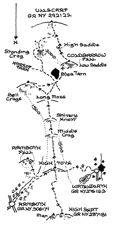
      This route should preferably be done only after a long dry spell or when the ground is frozen. In such conditions the moorland of the ridge between Thirlmere and Watendlath can provide a good day out, but if wet then just about anywhere else will be better! If starting at Armboth go up the signposted public path to Watendlath, and stay with it beyond the enclosure wall until the slope eases and a fairly level crossing on the left can be made to Armboth Fell. If the bend in the stream is aimed for a path through the heather to the summit may be found. It is clearly in view when standing on the top; which when the heather is in bloom is the perfect place to be. Descend the path back to the stream and it's continuation on the far bank. At present it does not run through to the main track up to High Tove, but is some help if rather wet. The main track climbs gradually to the big cairn on the top. From Watendlath the path to High Tove can clearly be seen winding up to the top of the enclosures. It has been well reconstructed, and it is a pity the work did not carry on ahead at the wall corner all the way to High Tove. Instead make the best of the soggy ground, and welcome the dry summit area on arriva1. The fence links High Tove and Ullscarf, but areas of peat hags poo1s and waterlogged grass will require detours. The right hand side of the fence is the best initially. The ground eventually rises beyond Shivery Knott, and then crosses Long Moss with more promising ground ahead. The fence goes part way up the slope, but when it turns sharply right continue up to the pleasant top adorned by an Ordnance Survey column. The summit is strictly nameless which seems a pity when less worthy places here have one! The imposing front of Standing Crag rises ahead along the ridge, and this presents the simplest route to Ullscarf from here. The path swings round the crag on the left, and climbs steadily to the extensive summit plateau. The preferred route goes down to the outlet of the tarn where swing south and ascend the ridge to Coldbarrow Fell (Low Saddle) a fine top with a wonderful view of the Watendlath valley. A good path heads up to High Saddle and the summit plateau of Ullscarf.

If High Seat is the objective the conditions underfoot from High Tove are no better at first. Follow the fence north and round the angle at Eddy Grave Stake avoiding as much water and bog as possible. The last section before the ascent to High Seat begins is especially bad to negotiate, but the summit is a pleasant place. From Ullscarf Watendlath is most easily reached along the bridleway by Blea Tarn, but a more interesting route is by Low Saddle then going down the moor east of Dock Tarn. The ground is not easy as the tarn is neared with the best walking being alongside the wall by High Crag to join the path from Stonethwaite. Turn right up to Dock Tarn after which the path starts it's decent to Watendlath. For Armboth the east ridge can be descended to the fine vantage point above Nab Crags reaching the road north of West Head. To retum to Armboth from High Seat a visit to Raven Crag is recommended. Descend the moor below Man, and aim for the gate in the deer fence due east. Turn left along the forest road to the signposted junction. After returning from Raven Crag go down the path to the Thirlmere dam and walk by the lake back to Armboth. To avoid another crossing of High Tove a descent by the path down Ashness Gill might be tried for a return to Watendlath. From the bridge walk by Surprise View, and finish by the track alongside Watendlath Beck.


----------------

ROUTE TWO. ULLSCARF FROM THIRLMERE VIA NAB CRAGS.
2.5 miles 1800ft of ascent

click to enlarge

   Walk north along the road from Steel End, and ascend a path rising behind West Head below Birk Crag. The path winds up to the ridge between Ullscarf Gill and the Wythburn valley. There is still some help from a path on the ridge itself, and the first mile or so is very attractive with the beacon and cairn above Nab Crags. The ridge is a place of pleasant rocks and small pools until the last mile up the moor to the summit. Keep going in a westerly direction aiming for the prominent Black Knott, and the top will appear eventually! For a varied return go along the ridge to Greenup, and round by the head of Far Easedale to Calf Crag and Steel Fell. The descent to Steel End is steep but without difficulty and Thirlmere is seen full length. Alternatively go north along the ridge, and then follow the fence to Standing Crag below which turn right down the bridleway to Harrop Tarn. The route down from the tarn on the left or north side of the stream to the car park is the best.


----------------

ROUTE THREE. HIGH SEAT FROM KESWICK VIA WALLA CRAG AND
BLEABERRY FELL.
4.5 miles 2050ft of ascent.

Ascent Breakdown

Distance

Ascent

miles

km

ft

metres

Keswick to Walla Crag.

2.25

3.6

950

290

Walla Crag to Bleaberry Fell.

1.25

2

900

274

Bleaberry Fell to High Seat.

1

1.6

200

61


click to enlarge

   Leave Keswick by Ambleside Road turning right into Springs Road at the bottom of Manor Brow, and follow it to it's terminus at the farm. A track in the company of Brockle Beck climbs up to the lane at Rakefoot where the beck is crossed for the last time, and a path alongside a wall goes up to Walla Crag. On the ascent stiles in the wall permit the last part of the climb to be done overlooking Keswick and the lake. Go down to the stile south of the summit, and take the Ashness Bridge path around the head of Cat Gill. Just beyond the prominent bend towards the valley above Falcon Crag look out for a narrow trod going up the slope on the left. This joins the main track to Bleaberry Fell above the worst of the wet ground on Low Moss, and emerges just below a sheepfold tucked in a sheltered position under a bank. The path from here to the foot of Bleaberry Fell has been upgraded thankfully so the final climb on the stone staircase to the summit should be possible with dry feet. Bleaberry Fell is an excellent viewpoint, but otherwise undistinguished so continue along the path negotiating the several peaty wet areas to a stile in a cross fence. Over the stile which is not in a good position either bear left to the foot of the summit slopes and the prominent path there, or go straight ahead to the top. Both routes will encounter more soggy ground before the welcome dry oasis of the summit is reachcd. The top is quite pleasant with the little peak of Man east of the fence, and the survey column sitting on top of some nice rocks which provide good opportunities for a sheltered lunch. There is a well marked path north west which leads down into Ashness Gill and the famous bridge from where a popular track runs above the road to the foot of Cat Gill. From here the lakeside can be followed back to Keswick visiting Friars Crag to complete a fine round trip.


----------------

ROUTE FOUR. HIGH SEAT FROM SHOULTHWAITE VIA THE BENN AND
RAVEN CRAG.
3.5 miles 1700ft of ascent.  

Ascent Breakdown

Distance

Ascent

miles

km

ft

metres

Shoulthwaite to The Benn

1.25

2

850

259

The Benn to Raven Crag

0.5

0.8

200

61

Raven Crag to High Seat

1.75

2.8

650

198


click to enlarge

 The ascent starts from the A591 at Shoulthwaite. There is parking on the old road opposite. Go up the track to the farm and immediately beyond a path turns up the slope on the right and soon comes to a forest road. If this is missed turn right when the foot of the forest road is met. The road ascends gradually curving up above Shoulthwaite Gill. When it makes a double bend go up a branch road on the left and at it's highest point look for a narrow path (almost overgrown at the moment) on the right. This climbs up to the top of The Benn which has a fine view of Raven Crag, and some merit in itself. Descend the south side carefully and follow traces of a path through the trees to rejoin the main forest road near a signposted junction. At one time a path had been created from here to The Benn with white marker posts which have sadly faded or disappeared, and the route is not obvious from this end. Follow the signed path up to Raven Crag which has a magnificent view of Thirlmere. Come back down to the clearing again, and after making a short detour to look at the Castle Crag fort continue up the forest road  as far as a gate in the deer fence. Go through the gate and head up the moor towards the small peak of Man which hides the actual top of High Seat until it is rounded on the left. The best way back is to retrace the ascent and perhaps descend the path to the road below Raven Crag. Tum left and after half a mile take to a broad track through the woods by Shoulthwaitc Moss. Another longer route is to reverse Route Three to Rakefoot there taking the field path to the A591. Down the hill on the left another field path can be used to cross the valley to Sykes, and then the lane and track below High Rigg lead back to the start.


----------------


ROUTE FIVE. GREAT CRAG FROM GRANGE VIA KINGS HOW AND BRUND FELL.
3 miles 1725ft of ascent
.

Ascent Breakdown

Distance

Ascent

miles

km

ft

metres

Grange to Kings How

1.25

2

1025

312

Kings How to Brund Fell

0.5

0.8

275

84

Brund Fell to Great Crag

1.25

2

425

130


click to enlarge

     Just south of the bridge at Grange a stile on the left provides access through Cummacatta Wood. The path climbs steadily to cross a low ridge before dropping down to the head of Troutdale. Bear right over the hollow to begin the ascent in earnest up the relaid path. There is a little relief before another short rise, ignoring a stile on the left, leads to Long Moss which the path skirts before tackling the little ridge of Kings How. There is a bit of easy scrambling before the crest of the ridge is gained, and a final short climb (Note the plaque) to the bare top. Descend south but watch for a path going down left to the stile seen below. Beyond the stile the path gradually climbs with a ladder stile en-route up to a shelf where tum left for Brund Fell. Having visited the rocky summit descend the path on the other side passing Jopplety How to another ladder stile. Cross this and follow the wall ahead not left down to the top of the bridleway between Watendlath and Rosthwaite. Directly opposite a stile indicates the path over the wetland, and this links to the path from Watendlath to Dock Tarn and Stonethwaite. This section has been diverted to preserve the fragile wetland area. Turn right up the slope over a long line of stepping stones, and beyond another stile the ground rises towards Great Crag and Dock Tam. As the ground levels out before the tarn look for a path on the right cutting through the little ridge to reveal the top of Great Crag across a marshy hollow. This is not easy territory but cut round to the right of the hollow, and a path should be found ascending the final rise through thick heather. The main northernmost top has a grand view of Watendlath and from the cairn to the west a birds eye view of Rosthwaite. The shortest way down but a steep and stony one is by Dock Tarn to Stonethwaite where the bridleway can be used to Rosthwaite, and perhaps the last part by New Bridge and the River Derwent. Altematively go back to the bridleway below Brund Fell, and descend left for Rosthwaite noting that part way down a path may be taken that goes down to the road through Frith Wood. A short way along the road the track to the Bowder Stone bears off leaving another short walk by the roadside to finish.


----------------

ROUTE SIX. HIGH RIGG FROM LEGBURTHWAITE VIA WREN CRAG AND VISITING GREAT HOW
4.25 miles 1375ft of ascent.

Ascent Breakdown

Distance

Ascent

miles

km

ft

metres

Legburthwaite to Great How.

1.25

2

550

168

Great How to Wren Crag.

1.75

2.8

500

152

Wren Crag to High Rigg.

1.25

2

325

99


click to enlarge


This delightful and popular walk to High Rigg begins at Smaithwaite Bridge on the main road to Keswick a short distance north of the Thirlmere dam road junction. The car park in the trees at Legburthwaite nearby is often used as the base for this short excursion. Great How has been added to the walk here rather than giving it a separate route, and the mileage is still modest. Cross the main road and south of the road to the Thirlmere Darn a track runs along the base of the wooded hillside. This turns up to the top of a low ridge where a signpost points the way to Great How up the track on the right. After the track has become a path a junction will be reached. Go right for a fine view of Thirlmere, and then back and up to the highest permitted point which has a restricted view. Return to the signposts at the base and descend right to the lakeside and the road by the dam. This is a beautiful place when the bluebells are in flower. The dam is worth a closer look if not previously seen before walking down the road back to the A591 at Smaithwaite Bridge. From the step stile or gate beyond the bridge the path rounds the end of the ridge to go along the flank of the fell down St John's in the Vale. Turn up the ridge on a well defined path before the bend is reached, and gain height through an area of delightful miniature pines which sadly are diminishing in numbers here. The top of Wren Crag is a fine viewpoint, and a slight descent follows before a rough scramble up to Long Band. An easier section along the ridge can be enjoyed before the path swings left over a stile before continuing north and crossing a hollow at a step stile. After climbing out of this another depression with marshy ground needs avoiding on the left. The path now ascends over a slight rise and the summit comes into view with it's prominent cairn. Most people will now go down north to the lovely little church, and walk back to Legburthwaite up St John's in the Vale.


Copyright (C) 2007 B S Baker