PLACE FELL AND HIGH RAISE
|
Place Fell occupies a
splendid position at the head of Ullswater rising within the curve of the
lake which it dominates, as well as the villages of Glenridding and
Patterdale. It is a colourful and bulky mass of ground with steep slopes
richly cloaked by birch and juniper above the lake, and bracken scree and
small crags everywhere. The summit is extensive with minor tops, and paths
winding their way down to valley and lake in a delightful way. Place Fell is
an excellent viewpoint for the Helvellyn and Fairfield ranges with the
valleys of Grisedale and Glenridding biting deeply into the hills in the
foreground. An ill defined ridge connects the fell at Boardale Hause with
Angletarn Pikes, and high ground continues curving above Hartsop to the main
High Street range on Rampsgill Head. This is the most important fell in the
group geographically, but High Raise to the north just overtops it in height.
Also featured here is the popular Kidsty Pike above Riggindale to which
walkers have blazed a trail on the way to High Street from Mardale Head and
Haweswater. If the golden eagles are in residence below Rough Crag the top of
Kidsty Pike is a good place to look for them. The narrow Straits of
Riggindale between Rampsgill Head and High Street marks the southern boundary
of this section. The eastern flanks of High Raise fall to Haweswater after
some initial hesitation while westwards lies the lovely Martindale to which
these fells form virtually all the boundaries. The secondary spurs of The Nab
and Beda Fell enclose the valleys of Bannerdale and Boardale. In a basin
between Angletarn Pikes and Brock Crags, both grand places to look down on
the head of the Patterdale valley, lies the jewel of this group Angle Tarn;
one of the loveliest in the district with a distinctive shoreline and tiny
islands. This is an area of great diversity of scenery, from the wild places
overlooking Haweswater to the softer charms of Martindale and the beautiful shores
of Ullswater. There is one more reason to look forward to a days walk here,
and that is because the head of Martindale has long been the home of deer.
They can often be seen, and if you are lucky enough to get reasonably close
make it a day to remember.
|
|
|
|
|
----------------
|
ROUTE ONE. PLACE FELL FROM MARTINDALE VIA HIGH
DODD.
2miles 1800ft of ascent. To High Dodd it is 1 mile 1075ft of ascent.
|
|
|
|
click to enlarge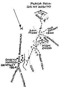
|
The ascent starts at
Garth Heads in Boardale where a short track leads down to a footbridge. Go up
right past a barn to join a path slanting up the fell. Higher up the path
from Sleet Fell connects and here turn left below the slopes of High Dodd.
The path begins to descend to the sheepfold on Low Moss, but at this point
swing back up the fell to the cairn on High Dodd. A direct route down to Low
Moss is easily made before the wide track up the facing slope to Place Fell
is tackled. The return is best effected by descending to Boardale Hause there
taking the rising path to Bedafell Knott on the opposite side of Boardale. Continue
along the undulating ridge to Beda Fell and descend over the delightful
little peak of Winter Crag. .
|
|
----------------
|
ROUTE TWO. PLACE FELL FROM MARTINDALE VIA WINTER
CRAG AND BEDA FELL.
4.5 miles 2250ft of ascent.
|
Ascent Breakdown
|
Distance
|
|
Ascent
|
|
|
|
miles
|
km
|
ft
|
metres
|
|
Martindale to Winter Crag.
|
1
|
1.6
|
500
|
152
|
|
Winter Crag to Beda Fell.
|
0.75
|
1.2
|
575
|
175
|
|
Beda Fell to Place Fell.
|
2.75
|
4.4
|
1175
|
358
|
|
|
|
|
click to enlarge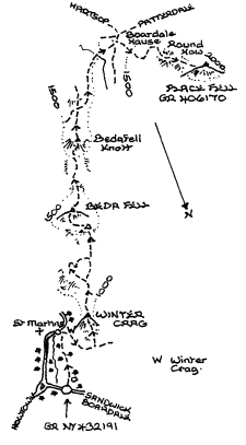
|
Although the Beda Fell
ridge can be gained from it's extremity it is far pleasanter to walk past The
Lodge to Winter Crag Farm and there ascend the path to the ridge. The path
drops down to Howsteadbrow in Boardale, but turn left along the ridge and
climb up to the rocky peak of Winter Crag. A little descent is followed by a
steady climb made interesting by an old grooved path above which the slopes
are easier. The lower cairn is prominent now and is easily visited on the
way. The main cairn is on a slight rise and level ground continues the ridge
though there are many rises and falls during it's traverse. When the path
from Martindale crosses just beyond Bedafell Knott turn right along it and
drop down to Boardale Hause. The slopes of Place Fell rise ahead and the
track is all too clear seeming to require a bit of effort. It is not
necessary to go all the way to the Hause as a path will be seen crossing the
grasslands and cutting the corner. My preferred route down to Martindale
would be to follow the path north eastwards by Low Moss and retaining the
ridge beyond High Dodd over Sleet Fell.The descent is quite steep but unless
done in icy conditions should present no problems.
|
|
----------------
|
ROUTE THREE. PLACE FELL FROM PATTERDALE VIA BIRK
FELL AND THE KNIGHT.
3
miles 1800ft of ascent.
|
Ascent Breakdown
|
Distance
|
|
Ascent
|
|
|
|
miles
|
km
|
ft
|
metres
|
|
Patterdale to Birk Fell.
|
2
|
3.2
|
1200
|
366
|
|
Birk Fell to The Knight.
|
0.5
|
0.8
|
200
|
61
|
|
The Knight to Place Fell.
|
0.5
|
0.8
|
400
|
122
|
|
|
|
|
click to enlarge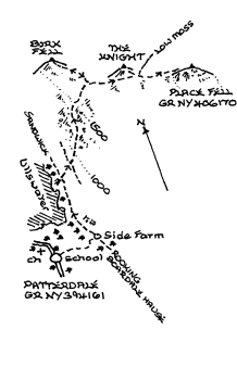
|
This route is a fine way
up to Place Fell far superior to the usual way by Boardale Hause. The first
objective is Side Farm down the track by the old school; where turn left
along the lakeside path to Sandwick. Follow this for about half a mile, and
watch for a path slanting up the hillside near a barn and some woodland.
There is an enclosure to the left of the path which meets the upper track
from the quarries and directly ahead the path for Place Fell begins. This
climbs up to the upper plateau at Hare Shaw; where as it bends sharply right
towards the main summit a detour should be made to the top of Birk Fell
(Bleaberry Knott). I have included it as one of my main tops as it
certainly has some merit, and possibly more than others usually regarded as
principal heights. The paths here are sketchy at present and the unspoilt summit
is delightful with a fine prospect of Ullswater. Return to the main path and
a short way up on the left is the little rocky ridge of The Knight. The
terrain eases after this before the last steeper slope below the summit. If a
slightly longer descent than the obvious one by Boardale Hause is wanted then
go north east down to the sheepfold at Low Moss, and there turn down left to
join the Lakeside path below Scalehow Force. There are many rises and falls
but the scenery is grand and deserves a leisurely appreciation.
|
|
----------------
|
ROUTE FOUR. HIGH RAISE FROM BURNBANKS VIA LOW
RAISE.
4.5 miles 2000ft of ascent.
|
|
|
|
click to enlarge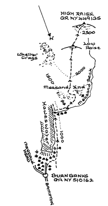
|
This is the most direct
way to High Raise from the foot of Haweswater. Proceed through the bungalows
and turn up by the plantation to join the track that runs alongside the
reservoir. This allows splendid views to the fells at the head of the valley.
When Measand Beck is reached turn up a path on the far side that permits a
little scrambling if desired, and there are some good vantage points for
Measand Forces. Do not cross the footbridge on the more level ground above,
but look for a path to the left on the slopes of Measand End. This is another
example of a graded track across a steep slope, but once on the top it is the
best part of two miles to the tumulus on Low Raise. It is not a bad idea to
leave the path on Long Grain to have a look down Whelter Crags. A simple walk
beyond Low Raise completes the journey to High Raise. Returns can be made
along the ridge northwards to Keasgill Head and then bearing right for Low
Kop and Measand; or with more effort go down the side of Whelter Crags to the
Castle Crag Fort and the lakeside path. A little longer than this and the
ridge down to Haweswater from Kidsty Pike can be used.
|
|
----------------
|
ROUTE FIVE. HIGH RAISE FROM MARDALE HEAD VIA
KIDSTY PIKE AND RAMPSGILL HEAD.
3.75 miles 2150ft of ascent.
|
Ascent Breakdown
|
Distance
|
Ascent
|
|
miles
|
km
|
ft
|
metres
|
|
Mardale Head to Kidsty Pike.
|
2.5
|
4
|
1900
|
579
|
|
Kidsty Pike to Rampsgill Head
|
0.5
|
0.8
|
100
|
31
|
|
Rampsgill Head to High Raise
|
0.75
|
1.2
|
150
|
46
|
|
|
|
|
click to enlarge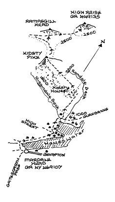
|
Take the path
round the head of the reservoir and ascend gradually to The Rigg where the
climb ahead may be studied. This is a nice viewpoint for the lake. Descend a
little into Riggindale, and follow the path round to the bridge over
Riggindale Beck. A path climbs the fellside above, and after some toil the
more interesting terrain of Kidsty Howes will be reached. Between here and
Kidsty Pike there is a more gradual ascent relieved by the view across
Riggindale to Rough Crag and High Street. Perhaps a Golden Eagle will be seen
if you are lucky. Leave the Pike as though heading for High Street, but as
the path starts to curve left beyond the slight depression keep ahead up
gentle slopes to the summit of Rampsgill Head. Visit the viewpoint cairn
above Rampsgill, and then follow the ridge north east for High Raise. Have a
look at the face of Rampsgill Head as the descent to the depression is made.
The supreme way down would be to go to High Street and descend over Long
Stile and Rough Crag. A longer route continuing over Mardale Ill Bell to Nan
Bield Pass is also an excellent route back.
|
|
----------------
|
ROUTE SIX. HIGH RAISE FROM HARTSOP VIA BROCK
CRAGS, REST DODD, THE KNOTT AND RAMPSGILL HEAD.
4.5 miles 2700ft of ascent.
|
Ascent Breakdown
|
Distance
|
Ascent
|
|
miles
|
km
|
ft
|
metres
|
|
Hartsop to Brock Crags.
|
1.5
|
2.4
|
1300
|
396
|
|
Brock Crags to Rest Dodd.
|
1
|
1.6
|
500
|
152
|
|
Rest Dodd to The Knott.
|
0.75
|
1.2
|
500
|
152
|
|
The Knott to Rampsgill Head
|
0.5
|
0.8
|
225
|
69
|
|
Rampsgill Head to High Raise.
|
0.75
|
1.2
|
175
|
53
|
|
|
|
|
click to enlarge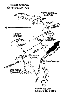
|
High Raise may
not often be the first thought as a main objective from Hartsop or Patterdale
as in the next route. However the plan is to reach the highest summit and
High Raise is just that. I have given separate ascent notes to Place Fell as
that is often the target for a days walk. Leave Hartsop from the car park
passing the sheep pens and up the surfaced lane to the filter house. Here
swing back on a good track that soon runs above the intake wall. A short way
ahead turn up right on a slanting path which will take you up to the
depression between Brock Crags and Satura Crag. A simple detour to the left
(by the wall at first) leads to the cairn overlooking Brothers Water. Go back
to the depression, and make the slight ascent to the wall corner on Satura
Crag where the Patterdale path comes in. At the far end of the rocky section
ahead the path going up to Rest Dodd will be seen. This fell can be omitted
if desired by staying on the main path direct to The Knott. The ascent of
Rest Dodd is simple enough, and gives a fine aspect of the line of crags
circling above the head of Bannerdale. There is a fair descent to the col before
the climb alongside the wall to The Knott. When the main path is reached it
can be followed round to the back of the summit leaving a very easy climb to
do. At the time of writing there were early signs of a connecting path from
The Knott to Rampsgill Head! Re-cross the main path and bear left up to the
latters summit perhaps with the help of this new path. Now only a simple walk
north east remains to arrive on High Raise. For a return to Hartsop go back
to The Knott and descend to Hayeswater. The Nab has not been included in these
notes, but can be added by following the wall met on the ascent to Rest Dodd to the
Rampsgill edge to pick up the ridge path. It will involve another two miles, and an
extra 700ft to the ascent. The fell is best visited by less active walkers on a shorter
expedition
|
|
----------------
|
ROUTE SEVEN. HIGH RAISE FROM PATTERDALE VIA
ANGLETARN PIKES, REST DODD, THE KNOTT AND RAMPSGILL HEAD.
5.25 miles 3000ft of ascent
|
Ascent Breakdown
|
Distance
|
Ascent
|
|
miles
|
km
|
ft
|
metres
|
|
Patterdale to Angletarn Pikes
|
1.75
|
2.8
|
1375
|
419
|
|
Angletarn Pikes to Rest Dodd.
|
1.5
|
2.4
|
725
|
221
|
|
Rest Dodd to The Knott.
|
0.75
|
1.2
|
500
|
152
|
|
The Knott to Rampsgill Head.
|
0.5
|
0.8
|
225
|
69
|
|
Rampsgill Head to High Raise
|
0.75
|
1.2
|
175
|
53
|
|
|
|
|
click to enlarge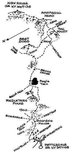
|
Leave Patterdale by the bridge
serving the houses at Rooking bearing left at the cottages up to a gate
accessing the fell. Ascend the path taking the lower alternative shortly
after though both do arrive on Boardale Hause. From the hause take the path
to the right which soon enters a shallow trough complete with stream at times
before crossing the top of Dubhow Beck to the foot of the main Angletarn
Pike. A short climb leads up to the narrow summit with it's grand view to
Kirkstone. The south top with a view of Angle Tarn can and should be visited
before rounding the tarn and proceeding to Satura Crag where route Six is
joined. Please refer to those notes for the rest of the ascent. The descent
to Hartsop is also the best variation route back to Patterdale.
|
|
Copyright (C) 2007 B S Baker
����������������������������������������������������������������������������������������������������������������������������������������������������������������������������������������������������������������������������������������������������������������������������������������������������������������������������������������������������������������������������������������������������������������������������������������������������������������������������������������������������������������������������������������������������������������������������������������������������������������������������������������������������������������������������������������������������������������������������������������������������������������������������������������������������������������������������������������������������������������������������������������������������������������������������������������������������������������������������������������������������������������������������������������������������������������������������������������������������������������������������������������������������������������������������������������������������������������������������������������������������������������������������������������������������������������������������������������������������������������������������������������������������������������������������������������������������������������������������������������������������������������������������������������������������������������������������������������������������������������������������������������������������������������������������������������������������������������������������������������������������������������������������������������������������������������������������������������������������������������������������������������������������������������������������������������������������������������������������������������������������������������������������������������������������������������������������������������������������������������������������������������������������������������������������������������������������������������������������������������������������������������������������������������������������������������������������������������������������������������������������������������������������������������������������������������������������������������������������������������������������������������������������������������������������������������������������������������������������������������������������������������������������������������������������������������������������������������������������������������������������������������������������������������������������������������������������������������������������������������������������������������������������������������������������������������������������������������������������������������������������������������������������������������������������������������������������������������������������������������������������������������������������������������������������������������������������������������������������������������������������������������������������������������������������������������������������������������������������������������������������������������������������������������������������������������������������������������������������������������������������������������������������������������������������������������������������������������������������������������������������������������������������������������������������������������������������������������������������������������������������������������������������������������������������������������������������������������������������������������������������������������������������������������������������������������������������������������������������������������������������������������������������������������������������������������������������������������������������������������������������������������������������������������������������������������������������������������������������������������������������������������������������������������������������������������������������������������������������������������������������������������������������������������������������������������������������������������������������������������������������������������������������������������������������������������������������������������������������������������������������������������������������������������������������������������������������������������������������������������������������������������������������������������������������������������������������������������������������������������������������������������������������������������������������������������������������������������������������������������������������������������������������������������������������������������������������������������������������������������������������������������������������������������������������������������������������������������������������������������������������������������������������������������������������������������������������������������������������������������������������������������������������������������������������������������������������������������������������������������������������������������������������������������������������������������������������������������������������������������������������������������������������������������������������������������������������������������������������������������������������������������������������������������������������������������������������������������������������������������������������������������������������������������������������������������������������������������������������������������������������������������������������������������������������������������������������������������������������������������������������������������������������������������������������������������������������������������������������������������������������������������������������������������������������������������������������������������������������������������������������������������������������������������������������������������������������������������������������������������������������������������������������������������������������������������������������������������������������������������������������������������������������������������������������������������������������������������������������������������������������������������������������������������������������������������������������������������������������������������������������������������������������������������������������������������������������������������������������������������������������������������������������������������������������������������������������������������������������������������������������������������������������������������������������������������������������������������������������������������������������������������������������������������������������������������������������������������������������������������������������������������������������������������������������������������������������������������������������������������������������������������������������������������������������������������������������������������������������������������������������������������������������������������������������������������������������������������������������������������������������������������������������������������������������������������������������������������������������������������������������������������������������������������������������������������������������������������������������������������������������������������������������������������������������������������������������������������������������������������������������������������������������������������������������������������������������������������������������������������������������������������������������������������������������������������������������������������������������������������������������������������������������������������������������������������������������������������������������������������������������������������������������������������������������������������������������������������������������������������������������������������������������������������������������������������������������������������������������������������������������������������������������������������������������������������������������������������������������������������������������������������������������������������������������������������������������������������������������������������������������������������������������������������������������������������������������������������������������������������������������������������������������������������������������������������������������������������������������������������������������������������������������������������������������������������������������������������������������������������������������������������������������������������������������������������������������������������������������������������������������������������������������������������������������������������������������������������������������������������������������������������������������������������������������������������������������������������������������������������������������������������������������������������������������������������������������������������������������������������������������������������������������������������������������������������������������������������������������������������������������������������������������������������������������������������������������������������������������������������������������������������������������������������������������������������������������������������������������������������������������������������������������������������������������������������������������������������������������������������������������������������������������������������������������������������������������������������������������������������������������������������������������������������������������������������������������������������������������������������������������������������������������������������������������������������������������������������������������������������������������������������������������������������������������������������������������������������������������������������������������������������������������������������������������������������������������������������������������������������������������������������������������������������������������������������������������������������������������������������������������������������������������������������������������������������������������������������������������������������������������������������������������������������������������������������������������������������������������������������������������������������������������������������������������������������������������������������������������������������������������������������������������������������������������������������������������������������������������������������������������������������������������������������������������������������������������������������������������������������������������������������������������������������������������������������������������������������������������������������������������������������������������������������������������������������������������������������������������������������������������������������������������������������������������������������������������������������������������������������������������������������������������������������������������������������������������������������������������������������������������������������������������������������������������������������������������������������������������������������������������������������������������������������������������������������������������������������������������������������������������������������������������������������������������������������������������������������������������������������������������������������������������������������������������������������������������������������������������������������������������������������������������������������������������������������������������������������������������������������������������������������������������������������������������������������������������������������������������������������������������������������������������������������������������������������������������������������������������������������������������������������������������������������������������������������������������������������������������������������������������������������������������������������������������������������������������������������������������������������������������������������������������������������������������������������������������������������������������������������������������������������������������������������������������������������������������������������������������������������������������������������������������������������������������������������������������������������������������������������������������������������������������������������������������������������������������������������������������������������������������������������������������������������������������������������������������������������������������������������������������������������������������������������������������������������������������������������������������������������������������������������������������������������������������������������������������������������������������������������������������������������������������������������������������������������������������������������������������������������������������������������������������������������������������������������������������������������������������������������������������������������������������������������������������������������������������������������������������������������������������������������������������������������������������������������������������������������������������������������������������������������������������������������������������������������������������������������������������������������������������������������������������������������������������������������������������������������������������������������������������������������������������������������������������������������������������������������������������������������������������������������������������������������������������������������������������������������������������������������������������������������������������������������������������������������������������������������������������������������������������������������������������������������������������������������������������������������������������������������������������������������������������������������������������������������������������������������������������������������������������������������������������������������������������������������������������������������������������������������������������������������������������������������������������������������������������������������������������������������������������������������������������������������������������������������������������������������������������������������������������������������������������������������������������������������������������������������������������������������������������������������������������������������������������������������������������������������������������������������������������������������������������������������������������������������������������������������������������������������������������������������������������������������������������������������������������������������������������������������������������������������������������������������������������������������������������������������������������������������������������������������������������������������������������������������������������������������������������������������������������������������������������������������������������������������������������������������������������������������������������������������������������������������������������������������������������������������������������������������������������������������������������������������������������������������������������������������������������������������������������������������������������������������������������������������������������������������������������������������������������������������������������������������������������������������������������������������������������������������������������������������������������������������������������������������������������������������������������������������������������������������������������������������������������������������������������������������������������������������������������������������������������������������������������������������������������������������������������������������������������������������������������������������������������������������������������������������������������������������������������������������������������������������������������������������������������������������������������������������������������������������������������������������������������������������������������������������������������������������������������������������������������������������������������������������������������������������������������������������������������������������������������������������������������������������������������������������������������������������������������������������������������������������������������������������������������������������������������������������������������������������������������������������������������������������������������������������������������������������������������������������������������������������������������������������������������������������������������������������������������������������������������������������������������������������������������������������������������������������������������������������������������������������������������������������������������������������������������������������������������������������������������������������������������������������������������������������������������������������������������������������������������������������������������������������������������������������������������������������������������������������������������������������������������������������������������������������������������������������������������������������������������������������������������������������������������������������������������������������������������������������������������������������������������������������������������������������������������������������������������������������������������������������������������������������������������������������������������������������������������������������������������������������������������������������������������������������������������������������������������������������������������������������������������������������������������������������������������������������������������������������������������������������������������������������������������������������������������������������������������������������������������������������������������������������������������������������������������������������������������������������������������������������������������������������������������������������������������������������������������������������������������������������������������������������������������������������������������������������������������������������������������������������������������������������������������������������������������������������������������������������������������������������������������������������������������������������������������������������������������������������������������������������������������������������������������������������������������������������������������������������������������������������������������������������������������������������������������������������������������������������������������������������������������������������������������������������������������������������������������������������������������������������������������������������������������������������������������������������������������������������������������������������������������������������������������������������������������������������������������������������������������������������������������������������������������������������������������������������������������������������������������������������������������������������������������������������������������������������������������������������������������������������������������������������������������������������������������������������������������������������������������������������������������������������������������������������������������������������������������������������������������������������������������������������������������������������������������������������������������������������������������������������������������������������������������������������������������������������������������������������������������������������������������������������������������������������������������������������������������������������������������������������������������������������������������������������������������������������������������������������������������������������������������������������������������������������������������������������������������������������������������������������������������������������������������������������������������������������������������������������������������������������������������������������������������������������������������������������������������������������������������������������������������������������������������������������������������������������������������������������������������������������������������������������������������������������������������������������������������������������������������������������������������������������������������������������������������������������������������������������������������������������������������������������������������������������������������������������������������������������������������������������������������������������������������������������������������������������������������������������������������������������������������������������������������������������������������������������������������������������������������������������������������������������������������������������������������������������������������������������������������������������������������������������������������������������������������������������������������������������������������������������������������������������������������������������������������������������������������������������������������������������������������������������������������������������������������������������������������������������������������������������������������������������������������������������������������������������������������������������������������������������������������������������������������������������������������������������������������������������������������������������������������������������������������������������������������������������������������������������������������������������������������������������������������������������������������������������������������������������������������������������������������������������������������������������������������������������������������������������������������������������������������������������������������������������������������������������������������������������������������������������������������������������������������������������������������������������������������������������������������������������������������������������������������������������������������������������������������������������������������������������������������������������������������������������������������������������������������������������������������������������������������������������������������������������������������������������������������������������������������������������������������������������������������������������������������������������������������������������������������������������������������������������������������������������������������������������������������������������������������������������������������������������������������������������������������������������������������������������������������������������������������������������������������������������������������������������������������������������������������������������������������������������������������������������������������������������������������������������������������������������������������������������������������������������������������������������������������������������������������������������������������������������������������������������������������������������������������������������������������������������������������������������������������������������������������������������������������������������������������������������������������������������������������������������������������������������������������������������������������������������������������������������������������������������������������������������������������������������������������������������������������������������������������������������������������������������������������������������������������������������������������������������������������������������������������������������������������������������������������������������������������������������������������������������������������������������������������������������������������������������������������������������������������������������������������������������������������������������������������������������������������������������������������������������������������������������������������������������������������������������������������������������������������������������������������������������������������������������������������������������������������������������������������������������������������������������������������������������������������������������������������������������������������������������������������������������������������������������������������������������������������������������������������������������������������������������������������������������������������������������������������������������������������������������������������������������������������������������������������������������������������������������������������������������������������������������������������������������������������������������������������������������������������������������������������������������������������������������������������������������������������������������������������������������������������������������������������������������������������������������������������������������������������������������������������������������������������������������������������������������������������������������������������������������������������������������������������������������������������������������������������������������������������������������������������������������������������������������������������������������������������������������������������������������������������������������������������������������������������������������������������������������������������������������������������������������������������������������������������������������������������������������������������������������������������������������������������������������������������������������������������������������������������������������������������������������������������������������������������������������������������������������������������������������������������������������������������������������������������������������������������������������������������������������������������������������������������������������������������������������������������������������������������������������������������������������������������������������������������������������������������������������������������������������������������������������������������������������������������������������������������������������������������������������������������������������������������������������������������������������������������������������������������������������������������������������������������������������������������������������������������������������������������������������������������������������������������������������������������������������������������������������������������������������������������������������������������������������������������������������������������������������������������������������������������������������������������������������������������������������������������������������������������������������������������������������������������������������������������������������������������������������������������������������������������������������������������������������������������������������������������������������������������������������������������������������������������������������������������������������������������������������������������������������������������������������������������������������������������������������������������������������������������������������������������������������������������������������������������������������������������������������������������������������������������������������������������������������������������������������������������������������������������������������������������������������������������������������������������������������������������������������������������������������������������������������������������������������������������������������������������������������������������������������������������������������������������������������������������������������������������������������������������������������������������������������������������������������������������������������������������������������������������������������������������������������������������������������������������������������������������������������������������������������������������������������������������������������������������������������������������������������������������������������������������������������������������������������������������������������������������������������������������������������������������������������������������������������������������������������������������������������������������������������������������������������������������������������������������������������������������������������������������������������������������������������������������������������������������������������������������������������������������������������������������������������������������������������������������������������������������������������������������������������������������������������������������������������������������������������������������������������������������������������������������������������������������������������������������������������������������������������������������������������������������������������������������������������������������������������������������������������������������������������������������������������������������������������������������������������������������������������������������������������������������������������������������������������������������������������������������������������������������������������������������������������������������������������������������������������������������������������������������������������������������������������������������������������������������������������������������������������������������������������������������������������������������������������������������������������������������������������������������������������������������������������������������������������������������������������������������������������������������������������������������������������������������������������������������������������������������������������������������������������������������������������������������������������������������������������������������������������������������������������������������������������������������������������������������������������������������������������������������������������������������������������������������������������������������������������������������������������������������������������������������������������������������������������������������������������������������������������������������������������������������������������������������������������������������������������������������������������������������������������������������������������������������������������������������������������������������������������������������������������������������������������������������������������������������������������������������������������������������������������������������������������������������������������������������������������������������������������������������������������������������������������������������������������������������������������������������������������������������������������������������������������������������������������������������������������������������������������������������������������������������������������������������������������������������������������������������������������������������������������������������������������������������������������������������������������������������������������������������������������������������������������������������������������������������������������������������������������������������������������������������������������������������������������������������������������������������������������������������������������������������������������������������������������������������������������������������������������������������������������������������������������������������������������������������������������������������������������������������������������������������������������������������������������������������������������������������������������������������������������������������������������������������������������������������������������������������������������������������������������������������������������������������������������������������������������������������������������������������������������������������������������������������������������������������������������������������������������������������������������������������������������������������������������������������������������������������������������������������������������������������������������������������������������������������������������������������������������������������������������������������������������������������������������������������������������������������������������������������������������������������������������������������������������������������������������������������������������������������������������������������������������������������������������������������������������������������������������������������������������������������������������������������������������������������������������������������������������������������������������������������������������������������������������������������������������������������������������������������������������������������������������������������������������������������������������������������������������������������������������������������������������������������������������������������������������������������������������������������������������������������������������������������������������������������������������������������������������������������������������������������������������������������������������������������������������������������������������������������������������������������������������������������������������������������������������������������������������������������������������������������������������������������������������������������������������������������������������������������������������������������������������������������������������������������������������������������������������������������������������������������������������������������������������������������������������������������������������������������������������������������������������������������������������������������������������������������������������������������������������������������������������������������������������������������������������������������������������������������������������������������������������������������������������������������������������������������������������������������������������������������������������������������������������������������������������������������������������������������������������������������������������������������������������������������������������������������������������������������������������������������������������������������������������������������������������������������������������������������������������������������������������������������������������������������������������������������������������������������������������������������������������������������������������������������������������������������������������������������������������������������������������������������������������������������������������������������������������������������������������������������������������������������������������������������������������������������������������������������������������������������������������������������������������������������������������������������������������������������������������������������������������������������������������������������������������������������������������������������������������������������������������������������������������������������������������������������������������������������������������������������������������������������������������������������������������������������������������������������������������������������������������������������������������������������������������������������������������������������������������������������������������������������������������������������������������������������������������������������������������������������������������������������������������������������������������������������������������������������������������������������������������������������������������������������������������������������������������������������������������������������������������������������������������������������������������������������������������������������������������������������������������������������������������������������������������������������������������������������������������������������������������������������������������������������������������������������������������������������������������������������������������������������������������������������������������������������������������������������������������������������������������������������������������������������������������������������������������������������������������������������������������������������������������������������������������������������������������������������������������������������������������������������������������������������������������������������������������������������������������������������������������������������������������������������������������������������������������������������������������������������������������������������������������������������������������������������������������������������������������������������������������������������������������������������������������������������������������������������������������������������������������������������������������������������������������������������������������������������������������������������������������������������������������������������������������������������������������������������������������������������������������������������������������������������������������������������������������������������������������������������������������������������������������������������������������������������������������������������������������������������������������������������������������������������������������������������������������������������������������������������������������������������������������������������������������������������������������������������������������������������������������������������������������������������������������������������������������������������������������������������������������������������������������������������������������������������������������������������������������������������������������������������������������������������������������������������������������������������������������������������������������������������������������������������������������������������������������������������������������������������������������������������������������������������������������������������������������������������������������������������������������������������������������������������������������������������������������������������������������������������������������������������������������������������������������������������������������������������������������������������������������������������������������������������������������������������������������������������������������������������������������������������������������������������������������������������������������������������������������������������������������������������������������������������������������������������������������������������������������������������������������������������������������������������������������������������������������������������������������������������������������������������������������������������������������������������������������������������������������������������������������������������������������������������������������������������������������������������������������������������������������������������������������������������������������������������������������������������������������������������������������������������������������������������������������������������������������������������������������������������������������������������������������������������������������������������������������������������������������������������������������������������������������������������������������������������������������������������������������������������������������������������������������������������������������������������������������������������������������������������������������������������������������������������������������������������������������������������������������������������������������������������������������������������������������������������������������������������������������������������������������������������������������������������������������������������������������������������������������������������������������������������������������������������������������������������������������������������������������������������������������������������������������������������������������������������������������������������������������������������������������������������������������������������������������������������������������������������������������������������������������������������������������������������������������������������������������������������������������������������������������������������������������������������������������������������������������������������������������������������������������������������������������������������������������������������������������������������������������������������������������������������������������������������������������������������������������������������������������������������������������������������������������������������������������������������������������������������������������������������������������������������������������������������������������������������������������������������������������������������������������������������������������������������������������������������������������������������������������������������������������������������������������������������������������������������������������������������������������������������������������������������������������������������������������������������������������������������������������������������������������������������������������������������������������������������������������������������������������������������������������������������������������������������������������������������������������������������������������������������������������������������������������������������������������������������������������������������������������������������������������������������������������������������������������������������������������������������������������������������������������������������������������������������������������������������������������������������������������������������������������������������������������������������������������������������������������������������������������������������������������������������������������������������������������������������������������������������������������������������������������������������������������������������������������������������������������������������������������������������������������������������������������������������������������������������������������������������������������������������������������������������������������������������������������������������������������������������������������������������������������������������������������������������������������������������������������������������������������������������������������������������������������������������������������������������������������������������������������������������������������������������������������������������������������������������������������������������������������������������������������������������������������������������������������������������������������������������������������������������������������������������������������������������������������������������������������������������������������������������������������������������������������������������������������������������������������������������������������������������������������������������������������������������������������������������������������������������������������������������������������������������������������������������������������������������������������������������������������������������������������������������������������������������������������������������������������������������������������������������������������������������������������������������������������������������������������������������������������������������������������������������������������������������������������������������������������������������������������������������������������������������������������������������������������������������������������������������������������������������������������������������������������������������������������������������������������������������������������������������������������������������������������������������������������������������������������������������������������������������������������������������������������������������������������������������������������������������������������������������������������������������������������������������������������������������������������������������������������������������������������������������������������������������������������������������������������������������������������������������������������������������������������������������������������������������������������������������������������������������������������������������������������������������������������������������������������������������������������������������������������������������������������������������������������