THE LANGDALE PIKES, HIGH RAISE AND HELM CRAG.
|
There are many mountain
views that are instantly recognisable on sight even to those visitors who
never set foot on them. Possibly the best known of all may well be that of the
Langdale Pikes which not only dominate the valley whose name they take, but
are additionally seen on the main approach to the area from Windermere, and
even at this distance their bold outline and grandeur is clear to the eye.
From other angles they are not so imposing especially to the north where
their summits may just appear in views from other fells overtopping the
sprawling slopes of Thunacar Knott. This does not in any way lessen their
appeal to walkers, and from the hills above Grasmere right round the southern
half of the district to Bowfell they are a notable presence in the landscape.
It can be fairly stated that the Langdale Pikes are all subsidiaries of
Thunacar Knott, as a study of any map will confirm. The parent fell does not
however measure up in scenic attractions to those of it's dependants, and a
scattering of pleasant rocks and boulders plus a small tarn is the best it
can manage. The main ridge continues north to High Raise the highest point of
this group, and again it is the appeal of the supporting fells that catches
the eye, even if it must be conceded that the view is superior to the others.
Nearby Sergeant Man draws the attention, though it's summit barely rises
above the plateau. It looks down onto the Stickle Tarn basin, and is additionally
part of a popular round from Grasmere. Apart from the wide ridge going north
from High Raise to Ullscarf and the heathery moors between Thirlmere and
Borrowdale, others spring up from Grasmere and Stonethwaite, and provide some
of the most delightful walking to be found anywhere. The most well known will
be the Helm Crag ridge; full of interest and charm which leads to the head of
Far Easedale, where Sergeant Man and High Raise can be accessed. Equally
attractive is the popular ridge from Silver How over Blea Rigg; while the
lesser known one over Tarn Crag is a splendid way to the tops. A tougher
prospect but no less scenically rewarding is the ascent of Eagle Crag from
Stonethwaite. I dont know of a better finish to a summit, but the lower part
is hard work. Considering the fell's position and outline above the valley I
am amazed that so few walkers consider it. I have to sing the praises of
Easedale and Codale Tarns above Grasmere; jewels of their kind which can
easily suggest a long siesta on their shores if the day is sunny and warm.
Try to resist the temptation though, and get on the ridges!
|
|
|
|
|
----------------
|
ROUTE ONE. HIGH RAISE FROM WYTHBURN VIA STEEL FELL
, CALF CRAG.
AND SERGEANT MAN 5 miles 2425ft of ascent.
|
Ascent Breakdown
|
Distance
|
Ascent
|
|
miles
|
km
|
ft
|
metres
|
|
Wythburn (Steel End) to Steel Fell.
|
1.25
|
2
|
1200
|
366
|
|
Steel Fell to Calf Crag.
|
1.5
|
2.4
|
250
|
76
|
|
Calf Crag to Sergeant Man.
|
1.75
|
2.8
|
850
|
259
|
|
Sergeant Man to High Raise.
|
0.5
|
0.8
|
125
|
38
|
|
|
|
|
click to enlarge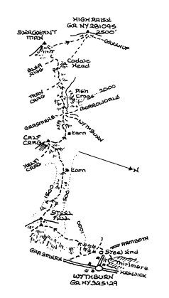
|
Take the path at Steel End
to Dunmail Raise and turn steeply up the fell beyond the plantation. The
ascent is quite straightforward apart from the gradient up the well defined
ridge. Conditions ease as height is gained; while the view back down to
Thirlmere is a good excuse for rests. The next stage to Calf Crag can be
rather marshy especially in the second half of the journey from the main
depression up to the top of the objective. This route now joined by Route Two
from Grasmere descends west over Brownrigg Moss then south west to the head
of Far Easedale. The path crossing here is the well used connection between
Grasmere and Borrowdale. Go directly across this into the confines of Meres
Beck which involves a little scramble prior to the easier slopes below Codale
Head. Sergeant Man comes into view beyond a slight hollow, and having climbed
to it’s rocky summit head north west to High Raise on the easiest of
gradients. The splendid all round view is ample compensation for the less
dramatic immediate surroundings.
In good weather a return to Wythburn can be made over Ullscarf to the
path from Watendlath below Standing Crag where a descent is then made to
Harrop Tarn and the roadside at Dobgill Bridge. The path on the north side of
Dob Gill down to the car park is the best underfoot.
|
|
----------------
|
ROUTE TWO. HIGH RAISE
FROM GRASMERE VIA HELM CRAG, GIBSON KNOTT, CALF CRAG AND SERGEANT MAN.
6 miles 2800ft of ascent.
|
Ascent Breakdown
|
Distance
|
Ascent
|
|
miles
|
km
|
ft
|
metres
|
Grasmere to Helm Crag
|
1.5
|
2.4
|
1100
|
335
|
|
Helm Crag to Gibson Knott.
|
0.75
|
1.2
|
275
|
84
|
|
Gibson Knott to Calf Crag
|
1.5
|
2.4
|
450
|
137
|
|
Calf Crag to Sergeant Man.
|
1.75
|
2.8
|
850
|
259
|
|
Sergeant Man to High Raise.
|
0.5
|
0.8
|
125
|
38
|
|
|
|
|
click to enlarge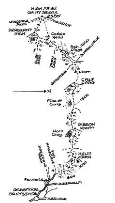
|
The lane into
Easedale is a popular start for several walks; the principal higher level one
being a traverse of the Helm Crag ridge. Follow the lane to it's terminus at
the cluster of houses below Helm Crag. The ascent of Helm Crag is signposted
where the track to Far Easedale and Borrowdale turns left at the gate. This
realigned route up the fell has been a great success, but the first section
is not one of the better construction jobs, and needs great care in descent.
From the top of the staircase of stones the rest of the climb takes advantage
of the simplest line of approach, and with a pronounced zig zag comes up to
the ridge. Helm Crag has a unique summit with rock outcrops at each end; the
north westerly one needing some resolve to make the top. A fair descent
preceeds a gradual climb to Gibson Knott whose cairns stand above the
steepest part of the Far Easedale face. The path is a joy to follow here, but
the ongoing ridge to Calf Crag becomes quite peaty and wet and some dodging
about may be needed. Go down west to the head of Far Easedale and keep
straight ahead into the confines of Mere Beck. There is a little bit of rock
scrambling, but the path is always obvious even in the marshier areas and
some small tarns add interest to the climb. Sergeant Man does not come into
view until Codale Head has been rounded, and the cairn there can easily be
visited. A slight descent is made after which the path coming up the ridge
from Blea Rigg and Stickle Tarn is joined for the last short ascent. There is
no loss of height to speak of if High Raise is the next objective, and apart
from a day of poor visibility when the proliferation of paths can be
confusing the correct one heading north west is well defined.
If returning to Grasmere there are several choices the best being down the
ridge over Blea Rigg to Silver How. The route of ascent can be partly reversed
noting that a path now links High Raise with Codale Head. Watch for a path on
the right with a cairn and near a small tarn beyond Codale Head. This
descends the ridge to Tarn Crag which has a fine ridge if it's own going down
to Far Easedale, and this is the subject of Route Three.
|
|
----------------
|
ROUTE THREE. HIGH
RAISE FROM GRASMERE VIA TARN CRAG AND
SERGEANT MAN.
4.5miles 2450ft of ascent.
|
Ascent Breakdown
|
Distance
|
Ascent
|
|
miles
|
km
|
ft
|
metres
|
|
Grasmere to Tarn Crag.
|
2.75
|
4.4
|
1625
|
495
|
|
Tarn Crag to Sergeant Man.
|
1.25
|
2
|
700
|
213
|
|
Sergeant Man to High Raise.
|
0.5
|
0.8
|
125
|
38
|
|
|
|
|
click to enlarge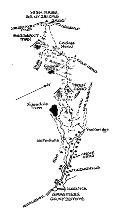
|
This walk complements
Route Two at first by using the Easedale Road to the foot of Helm Crag where
the track to Far Easedale and Borrowdale should be taken. Keep along this to
the footbridge by the Stythwaite Steps stones, and ascend the path directly
ahead when the Borrowdale one goes off to the right. At the point where the
ridge from Tarn Crag can be gained just after the intake wall has been left
behind, look for a path in the bracken. This ascent is somewhat variable
underfoot and the path has to be followed carefully in places, but overall
this is a grand climb with lovely views. The summit of Tarn Crag lies at the
head of a series of zig zags; though the cairn to the left of the path
overlooking Easedale Tarn must be visited. An undulating ridge with no loss
of height continues above Codale Tarn before the ground builds up and the
ascent to Codale Head begins. The path coming up from the head of Far
Easedale is joined on more level going and a left turn soon rounds Codale
Head to reveal Sergeant Man beyond a shallow basin. An easy climb leads to
the cairn perched high above the waters of Bright Beck and Stickle Tarn. An
easy half mile or so north west is all that remains to arrive on High Raise
which may not have the summit qualities of Sergeant Man but as an all round
viewpoint is vastly superior.
|
|
----------------
|
ROUTE FOUR. HIGH RAISE FROM ELTERWATER (Huntingstile)VIA
DOW BANK, SILVER HOW,
LANG HOW, GREAT CASTLE HOW, BLEA RIGG AND SERGEANT MAN.
6.25 miles 2875ft of ascent.
|
Ascent Breakdown
|
Distance
|
Ascent
|
|
miles
|
km
|
ft
|
metres
|
|
Elterwater to Dow Bank
|
1
|
1.6
|
750
|
229
|
|
Dow Bank to Silver How
|
1
|
1.6
|
450
|
137
|
|
Silver How to Lang How
|
0.75
|
1.2
|
175
|
53
|
|
Lang How to Great Castle How
|
1
|
1.6
|
450
|
137
|
|
Great Casle How to Blea Rigg.
|
0.5
|
0.8
|
225
|
69
|
|
Blca Rigg to Sergeant
|
1.5
|
2.4
|
700
|
213
|
|
Sergeant Man to High Raise.
|
0.5
|
0.8
|
125
|
38
|
|
|
|
|
click to enlarge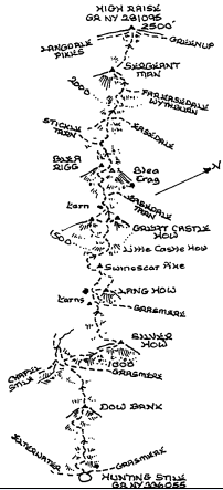
|
The starting point
for this walk is assumed to be Elterwater though Grasmere is a possible
alternative. Either way an initial climb to the ridge at Huntingstile Crag
north of the summit of the Red
Bank road will be required. Certainly for the purpose of suitable return routes
the valley starts are better and worth the early effort. If Elterwater or
Chapel Stile is the base then a descent can be made down to Dungeon Ghyll;
where the bus can be used back down the valley. As for Grasmere Routes Two or
Three can be considered amongst others. Assuming that the ridge has been
reached at Huntingstile Crag the
following notes take effect. There is some erosion of the path as it climbs
the bank by Huntingstile Crag as this is a very popular route. The ridge has
several rises and falls the most obvious being that of Dow Bank which
involves a steep climb. The higher ground of Silver How is now in view ahead,
and at the crossing of the Langdale to Grasmere path a little scramble is
needed to gain it. Go right up the eastern edge above the Grasmere face to
the summit. Looking ahead up the ridge the prominent top of Lang How stands
out half a mile away. It is easily climbed from the far side as the track
rounds it on the way to the next pronounced rise in altitude on Great Castle
How. There is a Great and a Little Castle How, and all the tops can be
visited with simple detours from the path which then crosses a marshy dip in
the ridge before climbing to Blea Rigg. The actual highest point which may
not have a cairn is the rocky rise behind the little shelter as the path
bears right to the Easedale side. A more level section follows, and then the
gradual climb to Sergeant Man begins with a change in direction from west to
north west. In mist this can be confusing territory. There are some good
views down to Easedale Tarn and Codale Tarn during the ascent and to the
Langdale Pikes. The peak of Sergeant Man hides from view for much of the
time, and is a welcome sight when finally appearing at close quarters. The
last half mile to High Raise is a simple walk in clear weather, and will be
welcome after previous exertions. As with all these walks there is always the
option to make one of the lower summits the target for the day, and there are
many places where alternative shorter routes can be decided. Although the
highest summit is the goal here it need not be in practise of course.
|
|
----------------
|
ROUTE FIVE. HIGH RAISE FROM DUNGEON GHYLL VIA THE
LANGDALE PIKES.
4.25 miles 2925ft of ascent.
|
Ascent Breakdown
|
Distance
|
Ascent
|
|
miles
|
km
|
ft
|
metres
|
|
Dungeon Ghyll to Loft Crag.
|
1.25
|
2
|
1975
|
602
|
|
Loft Crag to Pike O'Stickle.
|
0.5
|
0.8
|
125
|
38
|
|
Pike O'Stickle to Harrison Stickle
|
0.5
|
0.8
|
350
|
107
|
|
Harrison Sticle to Pavey Ark.
|
0.5
|
0.8
|
75
|
23
|
|
Pavey Ark to Thunacar Knott.
|
0.5
|
0.8
|
125
|
38
|
|
Thunacar Knott to High Raise.
|
1
|
1.6
|
275
|
84
|
|
|
|
|
click to enlarge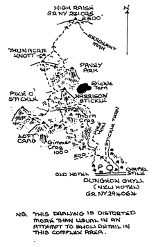
|
Leaving
the New Hotel at Dungeon Ghyll set off as for Mickleden or the Old Hotel, but
at the top of the first rise in the track turn right by the wall into the
ravine of Dungeon Ghyll the stream. Cross over the stones at once and climb
the path on the other side. This path has seen a lot of renewal work but
still presents a tough climb so soon in the day. Eventually Thorn Crag col
will be reached with Harrison Stickle ahead and Loft Crag on the left. The
latter can be gained by taking the path up a short scree gully, or if the
rocks are nice and dry by going straight up the facing slope. Pike O'Stickle
is seen ahead and the bumpy little ridge connects with it arriving at the
head of the Mickleden scree gully before the ultimate steep climb to the
small summit area. After admiring Bowfell and the other Pikes return to the
base and continue down to cross the infant stream onto the slopes of Harrison
Stickle. The left hand variation is the easiest but the more direct ascent
more interesting. The top is a superb place to look down Great Langdale while
Pavey Ark the next objective is a fine sight. It is obvious that the deep basin
of Stickle Tarn has to rounded and there are a few alternatives on the rim as
the path winds amongst the rocks. The ascent to the Ark is slight and again
the view is very good; though Stickle Tarn is not fully seen from the highest
point. Return over the damp depression and ascend the path north west to the
pleasant boulders on the double summit of Thunacar Knott which has a small
tarn between them. The final mile is due north joining the main track near
the depression which though soggy in places leads without any more drama to
the top of High Raise. Descents can be made over Sergeant Man and down to
Stickle Tarn; a fine and not overlong walk.
|
|
----------------
|
ROUTE SIX. HIGH RAISE FROM STONETHWAITE VIA EAGLE
CRAG AND SERGEANTS CRAG.
3.75 miles 2450ft of ascent.
|
Ascent Breakdown
|
Distance
|
Ascent
|
|
miles
|
km
|
ft
|
metres
|
|
Stonethwaite to Eagle Crag.
|
1.75
|
2.8
|
1350
|
412
|
|
Eagle Crag to Sergeants Crag
|
0.5
|
0.8
|
250
|
76
|
|
Sergeants Crag to High Raise.
|
1.5
|
2.4
|
850
|
259
|
|
|
|
|
click to enlarge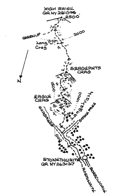
|
Cross the bridge at
Stonethwaite and bear right up the valley to the footbridge at the confluence
of the Greenup and Langstrath valleys. Go over the footbridge and a stile on
the left onto soggy ground that soon becomes overwhelmed by luxuriant
bracken. Keep on a narrow but clear path well above the stream bed as far as
the second wall, and turn up alongside it. A path is discernable in the
bracken, and gradually becomes clearer as it starts to wind around before
coming to a stile in the topmost corner. The conditions alter here
completely, and after a short gully is climbed the rest of the ascent is
sheer delight on little rock terraces with many a twist and turn before the
summit cairn perched on the highest crag is reached. A short descent by the
wall corner leads onto Sergeants Crag which has been a fine sight in the last
part of the climb. A good path makes it's way to it and this too is a most
attractive top. Now go down to the stile on the far side and over the wide
grasslands beyond aiming to the right of Long Crag, and gaining height by
using the several outcropping boulder areas to add some interest. Curve round
to the right below Low White Stones to the O S column and shelter on High
Raise. The easiest way back to Stonethwaite is to go down over Low White
Stones to Greenup where bear left into the valley taking care not to fall off
Lining Crag on the way. A longer route would be over Ullscarf there
descending to Low Saddle and Dock Tarn. Longer still but quite feasible is to
extend the walk to the Langdale Pikes, and then drop down to the Stake Pass
for Langstrath.
|
|
Copyright (C) 2007 B S Baker
�����������������������������������������������������������������������������������������������������������������������������������������������������������������������������������������������������������������������������������������������������������������������������������������������������������������������������������������������������������������������������������������������������������������������������������������������������������������������������������������������������������������������������������������������������������������������������������������������������������������������������������������������������������������������������������������������������������������������������������������������������������������������������������������������������������������������������������������������������������������������������������������������������������������������������������������������������������������������������������������������������������������������������������������������������������������������������������������������������������������������������������������������������������������������������������������������������������������������������������������������������������������������������������������������������������������������������������������������������������������������������������������������������������������������������������������������������������������������������������������������������������������������������������������������������������������������������������������������������������������������������������������������������������������������������������������������������������������������������������������������������������������������������������������������������������������������������������������������������������������������������������������������������������������������������������������������������������������������������������������������������������������������������������������������������������������������������������������������������������������������������������������������������������������������������������������������������������������������������������������������������������������������������������������������������������������������������������������������������������������������������������������������������������������������������������������������������������������������������������������������������������������������������������������������������������������������������������������������������������������������������������������������������������������������������������������������������������������������������������������������������������������������������������������������������������������������������������������������������������������������������������������������������������������������������������������������������������������������������������������������������������������������������������������������������������������������������������������������������������������������������������������������������������������������������������������������������������������������������������������������������������������������������������������������������������������������������������������������������������������������������������������������������������������������������������������������������������������������������������������������������������������������������������������������������������������������������������������������������������������������������������������������������������������������������������������������������������������������������������������������������������������������������������������������������������������������������������������������������������������������������������������������������������������������������������������������������������������������������������������������������������������������������������������������������������������������������������������������������������������������������������������������������������������������������������������������������������������������������������������������������������������������������������������������������������������������������������������������������������������������������������������������������������������������������������������������������������������������������������������������������������������������������������������������������������������������������������������������������������������������������������������������������������������������������������������������������������������������������������������������������������������������������������������������������������������������������������������������������������������������������������������������������������������������������������������������������������������������������������������������������������������������������������������������������������������������������������������������������������������������������������������������������������������������������������������������������������������������������������������������������������������������������������������������������������������������������������������������������������������������������������������������������������������������������������������������������������������������������������������������������������������������������������������������������������������������������������������������������������������������������������������������������������������������������������������������������������������������������������������������������������������������������������������������������������������������������������������������������������������������������������������������������������������������������������������������������������������������������������������������������������������������������������������������������������������������������������������������������������������������������������������������������������������������������������������������������������������������������������������������������������������������������������������������������������������������������������������������������������������������������������������������������������������������������������������������������������������������������������������������������������������������������������������������������������������������������������������������������������������������������������������������������������������������������������������������������������������������������������������������������������������������������������������������������������������������������������������������������������������������������������������������������������������������������������������������������������������������������������������������������������������������������������������������������������������������������������������������������������������������������������������������������������������������������������������������������������������������������������������������������������������������������������������������������������������������������������������������������������������������������������������������������������������������������������������������������������������������������������������������������������������������������������������������������������������������������������������������������������������������������������������������������������������������������������������������������������������������������������������������������������������������������������������������������������������������������������������������������������������������������������������������������������������������������������������������������������������������������������������������������������������������������������������������������������������������������������������������������������������������������������������������������������������������������������������������������������������������������������������������������������������������������������������������������������������������������������������������������������������������������������������������������������������������������������������������������������������������������������������������������������������������������������������������������������������������������������������������������������������������������������������������������������������������������������������������������������������������������������������������������������������������������������������������������������������������������������������������������������������������������������������������������������������������������������������������������������������������������������������������������������������������������������������������������������������������������������������������������������������������������������������������������������������������������������������������������������������������������������������������������������������������������������������������������������������������������������������������������������������������������������������������������������������������������������������������������������������������������������������������������������������������������������������������������������������������������������������������������������������������������������������������������������������������������������������������������������������������������������������������������������������������������������������������������������������������������������������������������������������������������������������������������������������������������������������������������������������������������������������������������������������������������������������������������������������������������������������������������������������������������������������������������������������������������������������������������������������������������������������������������������������������������������������������������������������������������������������������������������������������������������������������������������������������������������������������������������������������������������������������������������������������������������������������������������������������������������������������������������������������������������������������������������������������������������������������������������������������������������������������������������������������������������������������������������������������������������������������������������������������������������������������������������������������������������������������������������������������������������������������������������������������������������������������������������������������������������������������������������������������������������������������������������������������������������������������������������������������������������������������������������������������������������������������������������������������������������������������������������������������������������������������������������������������������������������������������������������������������������������������������������������������������������������������������������������������������������������������������������������������������������������������������������������������������������������������������������������������������������������������������������������������������������������������������������������������������������������������������������������������������������������������������������������������������������������������������������������������������������������������������������������������������������������������������������������������������������������������������������������������������������������������������������������������������������������������������������������������������������������������������������������������������������������������������������������������������������������������������������������������������������������������������������������������������������������������������������������������������������������������������������������������������������������������������������������������������������������������������������������������������������������������������������������������������������������������������������������������������������������������������������������������������������������������������������������������������������������������������������������������������������������������������������������������������������������������������������������������������������������������������������������������������������������������������������������������������������������������������������������������������������������������������������������������������������������������������������������������������������������������������������������������������������������������������������������������������������������������������������������������������������������������������������������������������������������������������������������������������������������������������������������������������������������������������������������������������������������������������������������������������������������������������������������������������������������������������������������������������������������������������������������������������������������������������������������������������������������������������������������������������������������������������������������������������������������������������������������������������������������������������������������������������������������������������������������������������������������������������������������������������������������������������������������������������������������������������������������������������������������������������������������������������������������������������������������������������������������������������������������������������������������������������������������������������������������������������������������������������������������������������������������������������������������������������������������������������������������������������������������������������������������������������������������������������������������������������������������������������������������������������������������������������������������������������������������������������������������������������������������������������������������������������������������������������������������������������������������������������������������������������������������������������������������������������������������������������������������������������������������������������������������������������������������������������������������������������������������������������������������������������������������������������������������������������������������������������������������������������������������������������������������������������������������������������������������������������������������������������������������������������������������������������������������������������������������������������������������������������������������������������������������������������������������������������������������������������������������������������������������������������������������������������������������������������������������������������������������������������������������������������������������������������������������������������������������������������������������������������������������������������������������������������������������������������������������������������������������������������������������������������������������������������������������������������������������������������������������������������������������������������������������������������������������������������������������������������������������������������������������������������������������������������������������������������������������������������������������������������������������������������������������������������������������������������������������������������������������������������������������������������������������������������������������������������������������������������������������������������������������������������������������������������������������������������������������������������������������������������������������������������������������������������������������������������������������������������������������������������������������������������������������������������������������������������������������������������������������������������������������������������������������������������������������������������������������������������������������������������������������������������������������������������������������������������������������������������������������������������������������������������������������������������������������������������������������������������������������������������������������������������������������������������������������������������������������������������������������������������������������������������������������������������������������������������������������������������������������������������������������������������������������������������������������������������������������������������������������������������������������������������������������������������������������������������������������������������������������������������������������������������������������������������������������������������������������������������������������������������������������������������������������������������������������������������������������������������������������������������������������������������������������������������������������������������������������������������������������������������������������������������������������������������������������������������������������������������������������������������������������������������������������������������������������������������������������������������������������������������������������������������������������������������������������������������������������������������������������������������������������������������������������������������������������������������������������������������������������������������������������������������������������������������������������������������������������������������������������������������������������������������������������������������������������������������������������������������������������������������������������������������������������������������������������������������������������������������������������������������������������������������������������������������������������������������������������������������������������������������������������������������������������������������������������������������������������������������������������������������������������������������������������������������������������������������������������������������������������������������������������������������������������������������������������������������������������������������������������������������������������������������������������������������������������������������������������������������������������������������������������������������������������������������������������������������������������������������������������������������������������������������������������������������������������������������������������������������������������������������������������������������������������������������������������������������������������������������������������������������������������������������������������������������������������������������������������������������������������������������������������������������������������������������������������������������������������������������������������������������������������������������������������������������������������������������������������������������������������������������������������������������������������������������������������������������������������������������������������������������������������������������������������������������������������������������������������������������������������������������������������������������������������������������������������������������������������������������������������������������������������������������������������������������������������������������������������������������������������������������������������������������������������������������������������������������������������������������������������������������������������������������������������������������������������������������������������������������������������������������������������������������������������������������������������������������������������������������������������������������������������������������������������������������������������������������������������������������������������������������������������������������������������������������������������������������������������������������������������������������������������������������������������������������������������������������������������������������������������������������������������������������������������������������������������������������������������������������������������������������������������������������������������������������������������������������������������������������������������������������������������������������������������������������������������������������������������������������������������������������������������������������������������������������������������������������������������������������������������������������������������������������������������������������������������������������������������������������������������������������������������������������������������������������������������������������������������������������������������������������������������������������������������������������������������������������������������������������������������������������������������������������������������������������������������������������������������������������������������������������������������������������������������������������������������������������������������������������������������������������������������������������������������������������������������������������������������������������������������������������������������������������������������������������������������������������������������������������������������������������������������������������������������������������������������������������������������������������������������������������������������������������������������������������������������������������������������������������������������������������������������������������������������������������������������������������������������������������������������������������������������������������������������������������������������������������������������������������������������������������������������������������������������������������������������������������������������������������������������������������������������������������������������������������������������������������������������������������������������������������������������������������������������������������������������������������������������������������������������������������������������������������������������������������������������������������������������������������������������������������������������������������������������������������������������������������������������������������������������������������������������������������������������������������������������������������������������������������������������������������������������������������������������������������������������������������������������������������������������������������������������������������������������������������������������������������������������������������������������������������������������������������������������������������������������������������������������������������������������������������������������������������������������������������������������������������������������������������������������������������������������������������������������������������������������������������������������������������������������������������������������������������������������������������������������������������������������������������������������������������������������������������������������������������������������������������������������������������������������������������������������������������������������������������������������������������������������������������������������������������������������������������������������������������������������������������������������������������������������������������������������������������������������������������������������������������������������������������������������������������������������������������������������������������������������������������������������������������������������������������������������������������������������������������������������������������������������������������������������������������������������������������������������������������������������������������������������������������������������������������������������������������������������������������������������������������������������������������������������������������������������������������������������������������������������������������������������������������������������������������������������������������������������������������������������������������������������������������������������������������������������������������������������������������������������������������������������������������������������������������������������������������������������������������������������������������������������������������������������������������������������������������������������������������������������������������������������������������������������������������������������������������������������������������������������������������������������������������������������������������������������������������������������������������������������������������������������������������������������������������������������������������������������������������������������������������������������������������������������������������������������������������������������������������������������������������������������������������������������������������������������������������������������������������������������������������������������������������������������������������������������������������������������������������������������������������������������������������������������������������������������������������������������������������������������������������������������������������������������������������������������������������������������������������������������������������������������������������������������������������������������������������������������������������������������������������������������������������������������������������������������������������������������������������������������������������������������������������������������������������������������������������������������������������������������������������������������������������������������������������������������������������������������������������������������������������������������������������������������������������������������������������������������������������������������������������������������������������������������������������������������������������������������������������������������������������������������������������������������������������������������������������������������������������������������������������������������������������������������������������������������������������������������������������������������������������������������������������������������������������������������������������������������������������������������������������������������������������������������������������������������������������������������������������������������������������������������������������������������������������������������������������������������������������������������������������������������������������������������������������������������������������������������������������������������������������������������������������������������������������������������������������������������������������������������������������������������������������������������������������������������������������������������������������������������������������������������������������������������������������������������������������������������������������������������������������������������������������������������������������������������������������������������������������������������������������������������������������������������������������������������������������������������������������������������������������������������������������������������������������������������������������������������������������������������������������������������������������������������������������������������������������������������������������������������������������������������������������������������������������������������������������������������������������������������������������������������������������������������������������������������������������������������������������������������������������������������������������������������������������������������������������������������������������������������������������������������������������������������������������������������������������������������������������������������������������������������������������������������������������������������������������������������������������������������������������������������������������������������������������������������������������������������������������������������������������������������������������������������������������������������������������������������������������������������������������������������������������������������������������������������������������������������������������������������������������������������������������������������������������������������������������������������������������������������������������������������������������������������������������������������������������������������������������������������������������������������������������������������������������������������������������������������������������������������������������������������������������������������������������������������������������������������������������������������������������������������������������������������������������������������������������������������������������������������������������������������������������������������������������������������������������������������������������������������������������������������������������������������������������������������������������������������������������������������������������������������������������������������������������������������������������������������������������������������������������������������������������������������������������������������������������������������������������������������������������������������������������������������������������������������������������������������������������������������������������������������������������������������������������������������������������������������������������������������������������������������������������������������������������������������������������������������������������������������������������������������������������������������������������������������������������������������������������������������������������������������������������������������������������������������������������������������������������������������������������������������������������������������������������������������������������������������������������������������������������������������������������������������������������������������������������������������������������������������������������������������������������������������������������������������������������������������������������������������������������������������������������������������������������������������������������������������������������������������������������������������������������������������������������������������������������������������������������������������������������������������������������������������������������������������������������������������������������������������������������������������������������������������������������������������������������������������������������������������������������������������������������������������������������������������������������������������������������������������������������������������������������������������������������������������������������������������������������������������������������������������������������������������������������������������������������������������������������������������������������������������������������������������������������������������������������������������������������������������������������������������������������������������������������������������������������������������������������������������������������������������������������������������������������������������������������������������������������������������������������������������������������������������������������������������������������������������������������������������������������������������������������������������������������������������������������������������������������������������������������������������������������������������������������������������������������������������������������������������������������������������������������������������������������������������������������������������������������������������������������������������������������������������������������������������������������������������������������������������������������������������������������������������������������������������������������������������������������������������������������������������������������������������������������������������������������������������������������������������������������������������������������������������������������������������������������������������������������������������������������������������������������������������������������������������������������������������������������������������������������������������������������������������������������������������������������������������������������������������������������������������������������������������������������������������������������������������������������������������������������������������������������������������������������������������������������������������������������������������������������������������������������������������������������������������������������������������������������������������������������������������������������������������������������������������������������������������������������������������������������������������������������������������������������������������������������������������������������������������������������������������������������������������������������������������������������������������������������������������������������������������������������������������������������������������������������������������������������������������������������������������������������������������������������������������������������������������������������������������������������������������������������������������������������������������������������������������������������������������������������������������������������������������������������������������������������������������������������������������������������������������������������������������������������������������������������������������������������������������������������������������������������������������������������������������������������������������������������������������������������������������������������������������������������������������������������������������������������������������������������������������������������������������������������������������������������������������������������������������������������������������������������������������������������������������������������������������������������������������������������������������������������������������������������������������������������������������������������������������������������������������������������������������������������������������������������������������������������������������������������������������������������������������������������������������������������������������������������������������������������������������������������������������������������������������������������������������������������������������������������������������������������������������������������������������������������������������������������������������������������������������������������������������������������������������������������������������������������������������������������������������������������������������������������������������������������������������������������������������������������������������������������������������������������������������������������������������������������������������������������������������������������������������������������������������������������������������������������������������������������������������������������������������������������������������������������������������������������������������������������������������������������������������������������������������������������������������������������������������������������������������������������������������������������������������������������������������������������������������������������������������������������������������������������������������������������������������������������������������������������������������������������������������������������������������������������������������������������������������������������������������������������������������������������������������������������������������������������������������������������������������������������������������������������������������������������������������������������������������������������������������������������������������������������������������������������������������������������������������������������������������������������������������������������������������������������������������������������������������������������������������������������������������������������������������������������������������������������������������������������������������������������������������������������������������������������������������������������������������������������������������������������������������������������������������������������������������������������������������������������������������������������������������������������������������������������������������������������������������������������������������������������������������������������������������������������������������������������������������������������������������������������������������������������������������������������������������������������������������������������������������������������������������������������������������������������������������������������������������������������������������������������������������������������������������������������������������������������������������������������������������������������������������������������������������������������������������������������������������������������������������������������������������������������������������������������������������������������������������������������������������������������������������������������������������������������������������������������������������������������������������������������������������������������������������������������������������������������������������������������������������������������������������������������������������������������������������������������������������������������������������������������������������������������������������������������������������������������������������������������������������������������������������������������������������������������������������������������������������������������������������������������������������������������������������������������������������������������������������������������������������������������������������������������������������������������������������������������������������������������������������������������������������������������������������������������������������������������������������������������������������������������������������������������������������������������������������������������������������������������������������������������������������������������������������������������������������������������������������������������������������������������������������������������������������������������������������������������������������������������������������������������������������������������������������������������������������������������������������������������������������������������������������������������������������������������������������������������������������������������������������������������������������������������������������������������������������������������������������������������������������������������������������������������������������������������������������������������������������������������������������������������������������������������������������������������������������������������������������������������������������������������������������������������������������������������������������������������������������������������������������������������������������������������������������������������������������������������������������������������������������������������������������������������������������������������������������������������������������������������������������������������������������������������������������������������������������������������������������������������������������������������������������������������������������������������������������������������������������������������������������������������������������������������������������������������������������������������������������������������������������������������������������������������������������������������������������������������������������������������������������������������������������������������������������������������������������������������������������������������������������������������������������������������������������������������������������������������������������������������������������������������������������������������������������������������������������������������������������������������������������������������������������������������������������������������������������������������������������������������������������������������������������������������������������������������������������������������������������������������������������������������������������������������������������������������������������������������������������������������������������������������������������������������������������������������������������������������������������������������������������������������������������������������������������������������������������������������������������������������������������������������������������������������������������������������������������������������������������������������������������������������������������������������������������������������������������������������������������������������������������������������������������������������������������������������������������������������������������������������������������������������������������������������������������������������������������������������������������������������������������������������������������������������������������������������������������������������������������������������������������������������������������������������������������������������������������������������������������������������������������������������������������������������������������������������������������������������������������������������������������������������������������������������������������������������������������������������������������������������������������������������������������������������������������������������������������������������������������������������������������������������������������������������������������������������������������������������������������������������������������������������������������������������������������������������������������������������������������������������������������������������������������������������������������������������������������������������������������������������������������������������������������������������������������������������������������������������������������������������������������������������������������������������������������������������������������������������������������������������������������������������������������������������������������������������������������������������������������������������������������������������������������������������������������������������������������������������������������������������������������������������������������������������������������������������������������������������������������������������������������������������������������������������������������������������������������������������������������������������������������������������������������������������������������������������������������������������������������������������������������������������������������������������������������������������������������������������������������������������������������������������������������������������������������������������������������������������������������������������������������������������������������������������������������������������������������������������������������������������������������������������������������������������������������������������������������������������������������������������������������������������������������������������������������������������������������������������������������������������������������������������������������������������������������������������������������������������������������������������������������������������������������������������������������������������������������������������������������������������������������������������������������������������������������������������������������������������������������������������������������������������������������������������������������������������������������������������������������������������������������������������������������������������������������������������������������������������������������������������������������������������������������������������������������������������������������������������������������������������������������������������������������������������������������������������������������������������������������������������������������������������������������������������������������������������������������������������������������������������������������������������������������������������������������������������������������������������������������������������������������������������������������������������������������������������������������������������������������������������������������������������������������������������������������������������������������������������������������������������������������������������������������������������������������������������������������������������������������������������������������������������������������������������������������������������������������������������������������������������������������������������������������������������������������������������������������������������������������������������������������